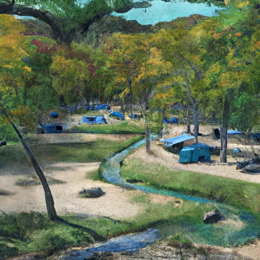
Lane Spring campground
Community Reviews
Been here? Share the conditions.
Reviews, ratings & photos are added in the free Snoflo iOS app — rate a spot, tag the conditions, and your visit is verified by location. Add or manage your reviews from the app.
Lane Spring
Reservations are not accepted at Lane Spring camping area, and campsites are available on a first-come, first-served basis. It is advisable to arrive early, especially during peak seasons, to secure a spot. The best time to visit Lane Spring camping area is during the spring and fall when the weather is pleasant and the surrounding nature is at its vibrant best. However, during the summer months, the campground becomes a popular destination for swimming and fishing, thanks to its proximity to the spring-fed pool and the picturesque Lane Spring Lake.
While visiting Lane Spring camping area, campers should be cautious of wildlife encounters and take necessary precautions to store food properly. It is also important to be mindful of the forest rules and regulations, including fire safety guidelines. With its stunning surroundings and a range of outdoor activities available, Lane Spring camping area is a great destination for nature enthusiasts looking to relax and unwind amidst the beauty of Missouri's wilderness.
What's on-site at Lane Spring
Key facilities Snoflo tracks for this campground. Confirm with the operator before booking -- amenities can change seasonally.
Plan your trip down to the hour
Same weather feed Snoflo's iOS app uses -- updated continuously from NOAA / yr.no.
Next 5 days, hour by hour
Temperature line with weather symbols on top, snow + rain accumulation as columns, humidity as a dotted line.
5-day forecast table
Every 3 hours, broken out across temperature, snow, rain, humidity, and wind. Each cell is colour-coded relative to the column min/max so trends jump out at a glance.
| Time | Condition | Temp (°F) | Snow (in) | Rain (in) | Humidity (%) | Wind (mps) | Wind dir |
|---|---|---|---|---|---|---|---|
| Loading detailed forecast… | |||||||
15-day temperature & precipitation
Daily temperatures, snow, and rain projected over the next two weeks. Hover any point for the full breakdown.
Other campgrounds in the area
Snoflo-tracked campsites within driving distance of Lane Spring, with reservations status.
| Campground | Reservations | Toilets | View |
|---|---|---|---|
| Lane Spring Recreation Area | ✓ | ✗ | → |
| Piney River Military - Fort Leonard Wood | ✓ | ✗ | → |
| Slabtown Recreation Area | ✗ | ✗ | → |
| Big Piney Equestrian Camp | ✓ | ✗ | → |
| Paddy Creek | ✗ | ✗ | → |
Nearby streamflow
USGS streamgauges within reach of Lane Spring -- pulled live from the National Water Information System.
| Streamgauge | Discharge | View |
|---|---|---|
| Little Piney Creek At Newburg | 144 cfs | → |
| Gasconade River At Jerome | 1,560 cfs | → |
| Big Piney Below Ft. Leonard Wood | 334 cfs | → |
| Big Piney River Near Big Piney | 265 cfs | → |
| Meramec River At Cook Station | 39 cfs | → |
| Roubidoux Creek Above Ft. Leonard Wood | 37 cfs | → |
Plan a longer trip
The closest parks, lakes, boat launches, and paddle runs so a camping night can grow into a full weekend.
Parks
- Conservation Area Bray (Marguerite)
- Little Prairie Conservation Area
- Fort Leonard Wood Towersite State Conservation Area Or Park
- Maramec Springs Trout Park
- Shawnee Mac Lakes Conservation Area
- Crooked Creek Conservation Area
Boat launches
- Crossroads Access
- Prairie Lake Road Phelps County
- Logan Road Pulaski County
- Mason Road Texas County
- Running River Drive Pulaski County
Paddle runs
- Northern Boundary Of Fort Leonard Wood To North Section Line Of Sec 31, T36n, R10w
- Missouri State Highway 17 To Fort Leonard Wood (Army Base)
- County Highway O, Laclede, County, Missouri To Ozark Spring
- State Highway 49 Bridge Near Dillard, Missouri To Forest Boundary In Sections 13/24, T38n, R3w
Camping essentials & Leave No Trace
- Pack it in, pack it out
- Take all trash, food scraps, and gear back with you to keep campsites clean and protect wildlife.
- Respect wildlife
- Observe animals from a distance, store food securely, and never feed wildlife to maintain natural behavior and safety.
- Know before you go
- Check weather, fire restrictions, trail conditions, and permit requirements to ensure a safe and well-planned trip.
- Minimize campfire impact
- Use established fire rings, keep fires small, fully extinguish them, or opt for a camp stove when fires are restricted.
- Leave what you find
- Preserve natural and cultural features by avoiding removal of plants, rocks, artifacts, or other elements of the environment.
Set push alerts in the Snoflo app
Save Lane Spring as a favorite, set a custom threshold (precipitation, snowpack, freezing temperatures), and the iOS app will push the moment conditions cross.
About Lane Spring
Can I make reservations at Lane Spring?
Yes -- this campground accepts reservations. Snoflo recommends booking early for peak season; check the operator (Recreation.gov / state park system / private operator) for the booking window and cancellation policy.
How fresh is the weather data on this page?
The hourly forecast updates throughout the day from the NOAA / yr.no public feeds. Streamflow data is pulled live from USGS streamgauges and snowpack from the NRCS SNOTEL network.
What's the best time of year to visit?
Use the 15-day temperature & precipitation outlook on this page to plan -- pick a window with comfortable temperatures and low precipitation. For longer trips, the 5-day hourly meteogram shows snow + rain accumulation hour-by-hour.
How do I get to Lane Spring?
Tap Directions in the hero above to open driving directions in Google Maps, or Open in map to center the Snoflo interactive map on the campground.
Can I get alerts when conditions change?
Yes -- alerts are managed through the Snoflo iOS app. Favorite this campground, set a threshold (temperature, snowpack, precipitation), and you'll get a push the moment it crosses.
Other campgrounds near here
Snoflo-tracked campgrounds within driving distance of Lane Spring.