Beaver Creek Campground Campground
Community Reviews
Been here? Share the conditions.
Reviews, ratings & photos are added in the free Snoflo iOS app — rate a spot, tag the conditions, and your visit is verified by location. Add or manage your reviews from the app.
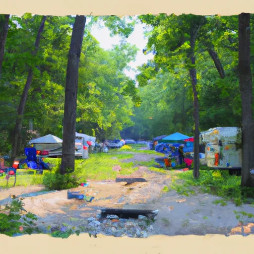
Beaver Creek Campground
Reservations are accepted at Beaver Creek Campground, ensuring that visitors can secure a spot in advance and plan their camping trip accordingly. It is recommended to make reservations early, especially during peak season, as this campground is a popular choice among campers.
The best time to visit Beaver Creek Campground is during the summer months when the weather is pleasant and conducive to outdoor activities. The campground is surrounded by stunning natural beauty, including lush forests and a nearby creek, providing ample opportunities for hiking, fishing, and wildlife viewing.
Campers should be mindful of their surroundings and take caution when exploring the area. It is advised to store food securely to prevent encounters with wildlife, and to be aware of any potential hazards such as uneven terrain or slippery trails. By following these guidelines and respecting the natural environment, visitors can have a safe and enjoyable experience at Beaver Creek Campground.
What's on-site at Beaver Creek Campground
Key facilities Snoflo tracks for this campground. Confirm with the operator before booking -- amenities can change seasonally.
Plan your trip down to the hour
Same weather feed Snoflo's iOS app uses -- updated continuously from NOAA / yr.no.
Next 5 days, hour by hour
Temperature line with weather symbols on top, snow + rain accumulation as columns, humidity as a dotted line.
5-day forecast table
Every 3 hours, broken out across temperature, snow, rain, humidity, and wind. Each cell is colour-coded relative to the column min/max so trends jump out at a glance.
| Time | Condition | Temp (°F) | Snow (in) | Rain (in) | Humidity (%) | Wind (mps) | Wind dir |
|---|---|---|---|---|---|---|---|
| Loading detailed forecast… | |||||||
15-day temperature & precipitation
Daily temperatures, snow, and rain projected over the next two weeks. Hover any point for the full breakdown.
Other campgrounds in the area
Snoflo-tracked campsites within driving distance of Beaver Creek Campground, with reservations status.
| Campground | Reservations | Toilets | View |
|---|---|---|---|
| Pine Bluff Campground | ✗ | ✗ | → |
| Coves Campsite | ✗ | ✗ | → |
| Lowney Creek Campground | ✗ | ✗ | → |
| Lowney Creek Group Campground | ✗ | ✗ | → |
| Little Beaver Lake - Pictured Rocks National Lake | ✗ | ✗ | → |
Nearby streamflow
USGS streamgauges within reach of Beaver Creek Campground -- pulled live from the National Water Information System.
| Streamgauge | Discharge | View |
|---|---|---|
| Au Train River At Forest Lake | 137 cfs | → |
| Manistique River Near Manistique | 986 cfs | → |
| Sturgeon River Near Nahma Junction | 109 cfs | → |
| Tahquamenon River Near Paradise | 638 cfs | → |
| Black River Near Garnet | 9 cfs | → |
| Middle Branch Escanaba River Nr Princeton | 139 cfs | → |
Nearby snow depths
NRCS SNOTEL stations within reach of Beaver Creek Campground -- relevant when planning a shoulder-season or alpine trip.
| SNOTEL station | Snowpack | 24h Snowfall | View |
|---|---|---|---|
| Munising | 27.0 in | 0.0 in | → |
| Mcmillan 7.4 N | 0.0 in | 2.1 in | → |
| Manistique 2.7 Nw | 0.0 in | 0.0 in | → |
| Newberry-Luce County Road Commission | 0.0 in | 0.0 in | → |
| Manistique Wwtp | 0.0 in | 0.0 in | → |
| Skandia 3.0 Sse | 0.0 in | 0.0 in | → |
Plan a longer trip
The closest parks, lakes, boat launches, and paddle runs so a camping night can grow into a full weekend.
Parks
- Wilderness Beaver Basin
- Pictured Rocks National Lakeshore
- Bay Furnace Recreation Area
- Wilderness Area Seney
- Wilderness Big Island Lake
- Wilderness Rock River Canyon
Boat launches
- Wwhite Pine Trail Burt Township
- Kingston Lake
- Twin Lake Road Hiawatha Township
- Creighton Road Hiawatha Township
- Hiawatha Township
- Stanley Lake Road Seney Township
Fishing spots
Points of interest
- Chapel Rock
- Miners Castle
- Au Sable Point Lighthouse
- Grand Island East Channel Lighthouse
- Grand Island North Lighthouse
- Grand Sable
Paddle runs
- Section 17, T48n, R17w (Boundary Of Pictured Rocks National Lakeshore Lands) To Mouth At Lake Superior
- County Road H-58 (Aka. Adams Trail/ Munising-Van Meer-Shingleton Rd.) To Mouth At Lake Superior
- From Sixteen Mile Lake To North Line Of Sec 26, T43n, R19w
- West Branch From Source In Sec 26, T46n, R23 W To Junction With County Road 444
Camping essentials & Leave No Trace
- Pack it in, pack it out
- Take all trash, food scraps, and gear back with you to keep campsites clean and protect wildlife.
- Respect wildlife
- Observe animals from a distance, store food securely, and never feed wildlife to maintain natural behavior and safety.
- Know before you go
- Check weather, fire restrictions, trail conditions, and permit requirements to ensure a safe and well-planned trip.
- Minimize campfire impact
- Use established fire rings, keep fires small, fully extinguish them, or opt for a camp stove when fires are restricted.
- Leave what you find
- Preserve natural and cultural features by avoiding removal of plants, rocks, artifacts, or other elements of the environment.
Set push alerts in the Snoflo app
Save Beaver Creek Campground as a favorite, set a custom threshold (precipitation, snowpack, freezing temperatures), and the iOS app will push the moment conditions cross.
About Beaver Creek Campground
Can I make reservations at Beaver Creek Campground?
This campground does not appear to accept reservations -- it's typically first-come, first-served. Arrive early on summer weekends.
How fresh is the weather data on this page?
The hourly forecast updates throughout the day from the NOAA / yr.no public feeds. Streamflow data is pulled live from USGS streamgauges and snowpack from the NRCS SNOTEL network.
What's the best time of year to visit?
Use the 15-day temperature & precipitation outlook on this page to plan -- pick a window with comfortable temperatures and low precipitation. For longer trips, the 5-day hourly meteogram shows snow + rain accumulation hour-by-hour.
How do I get to Beaver Creek Campground?
Tap Directions in the hero above to open driving directions in Google Maps, or Open in map to center the Snoflo interactive map on the campground.
Can I get alerts when conditions change?
Yes -- alerts are managed through the Snoflo iOS app. Favorite this campground, set a threshold (temperature, snowpack, precipitation), and you'll get a push the moment it crosses.
Other campgrounds near here
Snoflo-tracked campgrounds within driving distance of Beaver Creek Campground.