Lake Nineteen Campsites Campground
Community Reviews
Been here? Share the conditions.
Reviews, ratings & photos are added in the free Snoflo iOS app — rate a spot, tag the conditions, and your visit is verified by location. Add or manage your reviews from the app.
Lake Nineteen Campsites
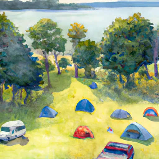
Reservations are accepted at Lake Nineteen Campsites, making it convenient for campers to secure a spot in advance. This ensures that visitors can plan their camping trip accordingly and avoid any disappointments upon arrival. It is advisable to make reservations early, especially during peak seasons, to guarantee availability.
The best time to visit Lake Nineteen Campsites is during the summer months when the weather is mild and conducive to outdoor activities. It is important to note that the campground may experience high occupancy during this period, so making reservations is highly recommended. Additionally, campers should be cautious of wildlife in the area, such as bears and other potentially dangerous animals. Proper food storage and adherence to safety guidelines are essential to ensure a safe and enjoyable camping experience.
In conclusion, Lake Nineteen Campsites in Michigan offers a range of amenities, accepts reservations, and is best enjoyed during the summer months. With its scenic beauty and diverse wildlife, it provides an ideal setting for nature enthusiasts and outdoor adventurers.
What's on-site at Lake Nineteen Campsites
Key facilities Snoflo tracks for this campground. Confirm with the operator before booking -- amenities can change seasonally.
Plan your trip down to the hour
Same weather feed Snoflo's iOS app uses -- updated continuously from NOAA / yr.no.
Next 5 days, hour by hour
Temperature line with weather symbols on top, snow + rain accumulation as columns, humidity as a dotted line.
5-day forecast table
Every 3 hours, broken out across temperature, snow, rain, humidity, and wind. Each cell is colour-coded relative to the column min/max so trends jump out at a glance.
| Time | Condition | Temp (°F) | Snow (in) | Rain (in) | Humidity (%) | Wind (mps) | Wind dir |
|---|---|---|---|---|---|---|---|
| Loading detailed forecast… | |||||||
15-day temperature & precipitation
Daily temperatures, snow, and rain projected over the next two weeks. Hover any point for the full breakdown.
Other campgrounds in the area
Snoflo-tracked campsites within driving distance of Lake Nineteen Campsites, with reservations status.
| Campground | Reservations | Toilets | View |
|---|---|---|---|
| Ironjaw Lake Campsites | ✓ | ✗ | → |
| Mowe Lake Campsites | ✓ | ✗ | → |
| Toms Lake Cabin | ✓ | ✗ | → |
| Swan Lake Campsites | ✓ | ✗ | → |
| Indian River Iii | ✗ | ✗ | → |
Nearby streamflow
USGS streamgauges within reach of Lake Nineteen Campsites -- pulled live from the National Water Information System.
| Streamgauge | Discharge | View |
|---|---|---|
| Sturgeon River Near Nahma Junction | 89 cfs | → |
| Au Train River At Forest Lake | 137 cfs | → |
| Manistique River Near Manistique | 919 cfs | → |
| Escanaba River At Cornell | 370 cfs | → |
| Ford River Near Hyde | 79 cfs | → |
| Middle Branch Escanaba River Nr Princeton | 103 cfs | → |
Nearby snow depths
NRCS SNOTEL stations within reach of Lake Nineteen Campsites -- relevant when planning a shoulder-season or alpine trip.
| SNOTEL station | Snowpack | 24h Snowfall | View |
|---|---|---|---|
| Manistique 2.7 Nw | 0.0 in | 0.0 in | → |
| Garden Corners | 0.0 in | 0.0 in | → |
| Munising | 27.0 in | 0.0 in | → |
| Manistique Wwtp | 0.0 in | 0.0 in | → |
| Gladstone No. 2 | 0.0 in | 0.0 in | → |
| Skandia 3.0 Sse | 0.0 in | 0.0 in | → |
Plan a longer trip
The closest parks, lakes, boat launches, and paddle runs so a camping night can grow into a full weekend.
Parks
- Wilderness Big Island Lake
- National Wild And Scenic River Indian, Michigan
- Palms Book State Park
- Pictured Rocks National Lakeshore
- Bay Furnace Recreation Area
- Carl D. Bradley Lakeview Memorial Park
Boat launches
- Fs 2799 Garden Township
- Triangle Lake
- Jackpine Lake
- Bass Lake
- Minerva Lake
- Grassy Lake Boat Launch Inwood Township
Fishing spots
Points of interest
- Toms Lake Cabin
- Mckeever Cabin
- Flowing Well
- Munising Ranger District Native Gardens
- Munising Rear Range Light
- Munising Front Range Light
Paddle runs
- West Branch From Source In Sec 26, T46n, R23 W To Junction With County Road 444
- From Sixteen Mile Lake To North Line Of Sec 26, T43n, R19w
- County Road H-58 (Aka. Adams Trail/ Munising-Van Meer-Shingleton Rd.) To Mouth At Lake Superior
- Section 17, T48n, R17w (Boundary Of Pictured Rocks National Lakeshore Lands) To Mouth At Lake Superior
Camping essentials & Leave No Trace
- Pack it in, pack it out
- Take all trash, food scraps, and gear back with you to keep campsites clean and protect wildlife.
- Respect wildlife
- Observe animals from a distance, store food securely, and never feed wildlife to maintain natural behavior and safety.
- Know before you go
- Check weather, fire restrictions, trail conditions, and permit requirements to ensure a safe and well-planned trip.
- Minimize campfire impact
- Use established fire rings, keep fires small, fully extinguish them, or opt for a camp stove when fires are restricted.
- Leave what you find
- Preserve natural and cultural features by avoiding removal of plants, rocks, artifacts, or other elements of the environment.
Set push alerts in the Snoflo app
Save Lake Nineteen Campsites as a favorite, set a custom threshold (precipitation, snowpack, freezing temperatures), and the iOS app will push the moment conditions cross.
About Lake Nineteen Campsites
Can I make reservations at Lake Nineteen Campsites?
Yes -- this campground accepts reservations. Snoflo recommends booking early for peak season; check the operator (Recreation.gov / state park system / private operator) for the booking window and cancellation policy.
How fresh is the weather data on this page?
The hourly forecast updates throughout the day from the NOAA / yr.no public feeds. Streamflow data is pulled live from USGS streamgauges and snowpack from the NRCS SNOTEL network.
What's the best time of year to visit?
Use the 15-day temperature & precipitation outlook on this page to plan -- pick a window with comfortable temperatures and low precipitation. For longer trips, the 5-day hourly meteogram shows snow + rain accumulation hour-by-hour.
How do I get to Lake Nineteen Campsites?
Tap Directions in the hero above to open driving directions in Google Maps, or Open in map to center the Snoflo interactive map on the campground.
Can I get alerts when conditions change?
Yes -- alerts are managed through the Snoflo iOS app. Favorite this campground, set a threshold (temperature, snowpack, precipitation), and you'll get a push the moment it crosses.
Other campgrounds near here
Snoflo-tracked campgrounds within driving distance of Lake Nineteen Campsites.