Copper Falls State Park Campground
Community Reviews
Been here? Share the conditions.
Reviews, ratings & photos are added in the free Snoflo iOS app — rate a spot, tag the conditions, and your visit is verified by location. Add or manage your reviews from the app.
Copper Falls State Park
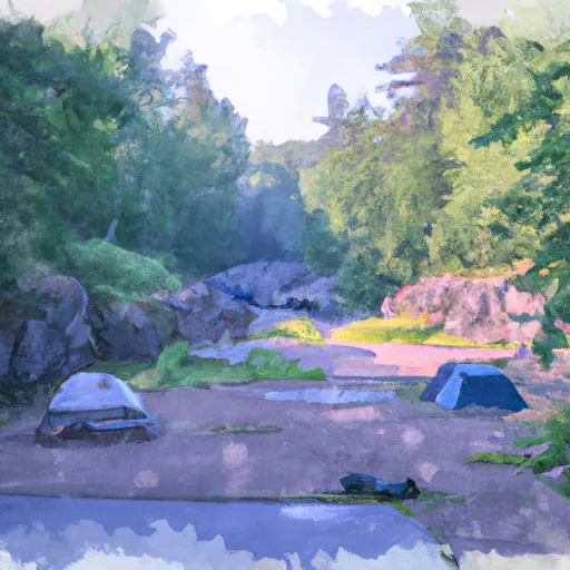
Reservations are highly recommended for camping at Copper Falls State Park, as it is a popular destination. Campers can make reservations online or by phone up to 11 months in advance. It is important to note that some sites are first-come, first-served, so it is advisable to arrive early to secure a spot during peak camping seasons.
The best time to visit Copper Falls State Park is during the summer months when the weather is warm and camping activities are in full swing. It is worth noting that the park is particularly stunning during the fall season when the leaves change color, creating a breathtaking scenery. Visitors can explore the park's many hiking trails, including the famous Doughboys' Trail, which offers scenic views of the park's waterfalls and rocky gorges.
While enjoying the camping area, campers should be cautious of the rugged terrain and potential wildlife encounters. It is recommended to stay on designated trails and be aware of any posted warnings or advisories. Following safety guidelines and respecting the park's rules will ensure a memorable and enjoyable camping experience at Copper Falls State Park.
What's on-site at Copper Falls State Park
Key facilities Snoflo tracks for this campground. Confirm with the operator before booking -- amenities can change seasonally.
Plan your trip down to the hour
Same weather feed Snoflo's iOS app uses -- updated continuously from NOAA / yr.no.
Next 5 days, hour by hour
Temperature line with weather symbols on top, snow + rain accumulation as columns, humidity as a dotted line.
5-day forecast table
Every 3 hours, broken out across temperature, snow, rain, humidity, and wind. Each cell is colour-coded relative to the column min/max so trends jump out at a glance.
| Time | Condition | Temp (°F) | Snow (in) | Rain (in) | Humidity (%) | Wind (mps) | Wind dir |
|---|---|---|---|---|---|---|---|
| Loading detailed forecast… | |||||||
15-day temperature & precipitation
Daily temperatures, snow, and rain projected over the next two weeks. Hover any point for the full breakdown.
Other campgrounds in the area
Snoflo-tracked campsites within driving distance of Copper Falls State Park, with reservations status.
| Campground | Reservations | Toilets | View |
|---|---|---|---|
| North Camp Area | ✓ | ✓ | → |
| Group Camp | ✗ | ✗ | → |
| South Camp Area | ✗ | ✗ | → |
| Sandy Ledges Campsite | ✗ | ✗ | → |
| Wren Falls | ✗ | ✗ | → |
Nearby streamflow
USGS streamgauges within reach of Copper Falls State Park -- pulled live from the National Water Information System.
| Streamgauge | Discharge | View |
|---|---|---|
| Bad River Near Mellen | 101 cfs | → |
| Bad River Near Odanah | 78 cfs | → |
| White River Near Ashland | 175 cfs | → |
| Whittlesey Creek Near Ashland | 21 cfs | → |
| North Fish Creek Near Moquah | 55 cfs | → |
| Black River Near Bessemer | 19 cfs | → |
Nearby snow depths
NRCS SNOTEL stations within reach of Copper Falls State Park -- relevant when planning a shoulder-season or alpine trip.
| SNOTEL station | Snowpack | 24h Snowfall | View |
|---|---|---|---|
| Upson | 0.0 in | 0.0 in | → |
| Ashland | 0.0 in | 0.0 in | → |
| Nohrsc Pence 0.1 E | 0.0 in | 0.0 in | → |
| Clam Lake 4w | 0.0 in | 0.0 in | → |
| Nohrsc Clam Lake 4 W | 0.0 in | 0.0 in | → |
Plan a longer trip
The closest parks, lakes, boat launches, and paddle runs so a camping night can grow into a full weekend.
Parks
- Copper Falls State Park
- Great Divide Wayside Park
- Marian Park Pavillion
- Bayfield County Park
- Gile County Park
- Whittlesey Creek National Wildlife Refuge
Boat launches
- Eureka Lake -- Access
- Lake Galilee -- Wes Jones Memorial Boat Landing
- Meder Lake - Access
- English Lake -- Access
- Long Lake -- Access At E Side Lake
- Caroline Lake - Access At Sw End Of Lake
Fishing spots
Camping essentials & Leave No Trace
- Pack it in, pack it out
- Take all trash, food scraps, and gear back with you to keep campsites clean and protect wildlife.
- Respect wildlife
- Observe animals from a distance, store food securely, and never feed wildlife to maintain natural behavior and safety.
- Know before you go
- Check weather, fire restrictions, trail conditions, and permit requirements to ensure a safe and well-planned trip.
- Minimize campfire impact
- Use established fire rings, keep fires small, fully extinguish them, or opt for a camp stove when fires are restricted.
- Leave what you find
- Preserve natural and cultural features by avoiding removal of plants, rocks, artifacts, or other elements of the environment.
Set push alerts in the Snoflo app
Save Copper Falls State Park as a favorite, set a custom threshold (precipitation, snowpack, freezing temperatures), and the iOS app will push the moment conditions cross.
About Copper Falls State Park
Can I make reservations at Copper Falls State Park?
Yes -- this campground accepts reservations. Snoflo recommends booking early for peak season; check the operator (Recreation.gov / state park system / private operator) for the booking window and cancellation policy.
How fresh is the weather data on this page?
The hourly forecast updates throughout the day from the NOAA / yr.no public feeds. Streamflow data is pulled live from USGS streamgauges and snowpack from the NRCS SNOTEL network.
What's the best time of year to visit?
Use the 15-day temperature & precipitation outlook on this page to plan -- pick a window with comfortable temperatures and low precipitation. For longer trips, the 5-day hourly meteogram shows snow + rain accumulation hour-by-hour.
How do I get to Copper Falls State Park?
Tap Directions in the hero above to open driving directions in Google Maps, or Open in map to center the Snoflo interactive map on the campground.
Can I get alerts when conditions change?
Yes -- alerts are managed through the Snoflo iOS app. Favorite this campground, set a threshold (temperature, snowpack, precipitation), and you'll get a push the moment it crosses.
Other campgrounds near here
Snoflo-tracked campgrounds within driving distance of Copper Falls State Park.