Arrowhead Point campground
Community Reviews
Been here? Share the conditions.
Reviews, ratings & photos are added in the free Snoflo iOS app — rate a spot, tag the conditions, and your visit is verified by location. Add or manage your reviews from the app.
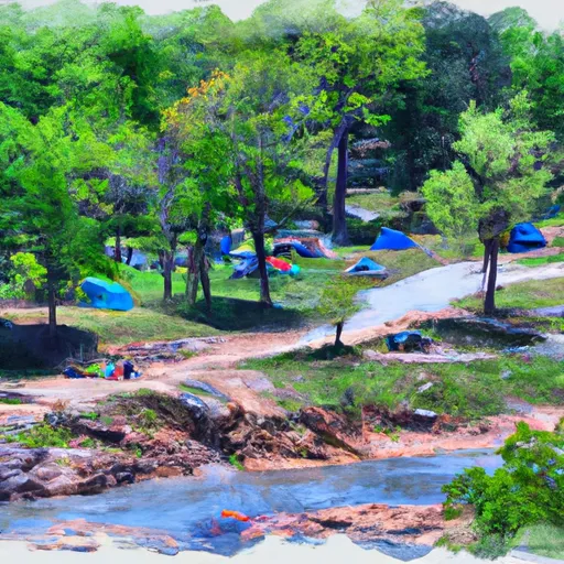
Arrowhead Point
Reservations are accepted at Arrowhead Point camping area, allowing visitors to secure their spot in advance. This ensures that campers can plan their trip without worrying about the availability of sites. It is recommended to make reservations, especially during peak seasons, to guarantee a spot.
The best time to visit Arrowhead Point camping area is during the spring and fall seasons when the weather is mild and pleasant. These seasons provide opportunities for outdoor activities like hiking, fishing, and bird-watching. However, it is important to note that the area may experience heavy rainfall during certain periods, so it is advised to check the weather forecast before planning a trip.
While enjoying the campground, campers should be cautious of wildlife encounters, including snakes and insects. It is essential to take necessary precautions to avoid any unwanted interactions. Furthermore, campers are encouraged to follow leave-no-trace principles to preserve the natural beauty of the area and respect the environment.
In conclusion, Arrowhead Point camping area in Arkansas offers a range of amenities, accepts reservations, and is best visited during the spring and fall seasons. Campers should be aware of potential wildlife encounters and practice responsible camping to ensure a memorable and enjoyable experience in this picturesque location.
What's on-site at Arrowhead Point
Key facilities Snoflo tracks for this campground. Confirm with the operator before booking -- amenities can change seasonally.
Plan your trip down to the hour
Same weather feed Snoflo's iOS app uses -- updated continuously from NOAA / yr.no.
Next 5 days, hour by hour
Temperature line with weather symbols on top, snow + rain accumulation as columns, humidity as a dotted line.
5-day forecast table
Every 3 hours, broken out across temperature, snow, rain, humidity, and wind. Each cell is colour-coded relative to the column min/max so trends jump out at a glance.
| Time | Condition | Temp (°F) | Snow (in) | Rain (in) | Humidity (%) | Wind (mps) | Wind dir |
|---|---|---|---|---|---|---|---|
| Loading detailed forecast… | |||||||
15-day temperature & precipitation
Daily temperatures, snow, and rain projected over the next two weeks. Hover any point for the full breakdown.
Other campgrounds in the area
Snoflo-tracked campsites within driving distance of Arrowhead Point, with reservations status.
| Campground | Reservations | Toilets | View |
|---|---|---|---|
| Star Of The West - Lake Greeson | ✓ | ✓ | → |
| Self Creek - Lake Greeson | ✗ | ✗ | → |
| Rock Creek - Lake Greeson | ✗ | ✗ | → |
| Daisy State Park | ✓ | ✗ | → |
| Kirby Landing - Lake Greeson | ✓ | ✗ | → |
Nearby streamflow
USGS streamgauges within reach of Arrowhead Point -- pulled live from the National Water Information System.
| Streamgauge | Discharge | View |
|---|---|---|
| Little Missouri River Near Langley | 68 cfs | → |
| Caddo River Near Caddo Gap | 151 cfs | → |
| Saline River Near Lockesburg | 134 cfs | → |
| Ouachita River Near Mount Ida | 1,200 cfs | → |
| Antoine River At Antoine | 81 cfs | → |
| Cossatot River Near Vandervoort | 206 cfs | → |
Plan a longer trip
The closest parks, lakes, boat launches, and paddle runs so a camping night can grow into a full weekend.
Parks
- Daisy State Park
- Mount Magazine Wildlife Management Area
- National Wild And Scenic River Little Missouri, Arkansas
- Caney Creek Wildlife Management Area
- Lake Greeson Wildlife Management Area
- Glenwood City Park
Boat launches
- Self Creek Ramp Road Daisy
- Daisy State Park - Area C Daisy
- Daisy State Park - Area East Daisy
- Howard County
- Blue Ridge Road Howard County
- Sevier County
Fishing spots
Camping essentials & Leave No Trace
- Pack it in, pack it out
- Take all trash, food scraps, and gear back with you to keep campsites clean and protect wildlife.
- Respect wildlife
- Observe animals from a distance, store food securely, and never feed wildlife to maintain natural behavior and safety.
- Know before you go
- Check weather, fire restrictions, trail conditions, and permit requirements to ensure a safe and well-planned trip.
- Minimize campfire impact
- Use established fire rings, keep fires small, fully extinguish them, or opt for a camp stove when fires are restricted.
- Leave what you find
- Preserve natural and cultural features by avoiding removal of plants, rocks, artifacts, or other elements of the environment.
Set push alerts in the Snoflo app
Save Arrowhead Point as a favorite, set a custom threshold (precipitation, snowpack, freezing temperatures), and the iOS app will push the moment conditions cross.
About Arrowhead Point
Can I make reservations at Arrowhead Point?
Yes -- this campground accepts reservations. Snoflo recommends booking early for peak season; check the operator (Recreation.gov / state park system / private operator) for the booking window and cancellation policy.
How fresh is the weather data on this page?
The hourly forecast updates throughout the day from the NOAA / yr.no public feeds. Streamflow data is pulled live from USGS streamgauges and snowpack from the NRCS SNOTEL network.
What's the best time of year to visit?
Use the 15-day temperature & precipitation outlook on this page to plan -- pick a window with comfortable temperatures and low precipitation. For longer trips, the 5-day hourly meteogram shows snow + rain accumulation hour-by-hour.
How do I get to Arrowhead Point?
Tap Directions in the hero above to open driving directions in Google Maps, or Open in map to center the Snoflo interactive map on the campground.
Can I get alerts when conditions change?
Yes -- alerts are managed through the Snoflo iOS app. Favorite this campground, set a threshold (temperature, snowpack, precipitation), and you'll get a push the moment it crosses.
Other campgrounds near here
Snoflo-tracked campgrounds within driving distance of Arrowhead Point.