Upper Cache Creek Campground
Community Reviews
Been here? Share the conditions.
Reviews, ratings & photos are added in the free Snoflo iOS app — rate a spot, tag the conditions, and your visit is verified by location. Add or manage your reviews from the app.
Upper Cache Creek
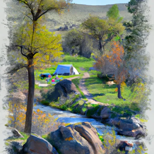
The campground offers 11 first-come, first-served campsites with amenities such as fire rings, picnic tables, and vault toilets. There is no potable water available, so campers must bring their own or treat water from the nearby creek.
Nearby points of interest include the Yellowstone River, which is known for its world-class fly fishing and scenic float trips. Visitors can also explore the nearby towns of Livingston and Gardiner, which offer shopping, dining, and entertainment options.
An interesting fact about the area is that it was once a popular mining site during the late 1800s and early 1900s. Today, visitors can still see remnants of the old mining structures and equipment.
The best time of year to visit is during the summer months, with average temperatures ranging from the mid-70s to low 80s Fahrenheit. However, the area is also popular for winter activities such as snowshoeing and cross-country skiing.
What's on-site at Upper Cache Creek
Key facilities Snoflo tracks for this campground. Confirm with the operator before booking -- amenities can change seasonally.
Plan your trip down to the hour
Same weather feed Snoflo's iOS app uses -- updated continuously from NOAA / yr.no.
Next 5 days, hour by hour
Temperature line with weather symbols on top, snow + rain accumulation as columns, humidity as a dotted line.
5-day forecast table
Every 3 hours, broken out across temperature, snow, rain, humidity, and wind. Each cell is colour-coded relative to the column min/max so trends jump out at a glance.
| Time | Condition | Temp (°F) | Snow (in) | Rain (in) | Humidity (%) | Wind (mps) | Wind dir |
|---|---|---|---|---|---|---|---|
| Loading detailed forecast… | |||||||
15-day temperature & precipitation
Daily temperatures, snow, and rain projected over the next two weeks. Hover any point for the full breakdown.
Other campgrounds in the area
Snoflo-tracked campsites within driving distance of Upper Cache Creek, with reservations status.
| Campground | Reservations | Toilets | View |
|---|---|---|---|
| 3c4 | ✗ | ✗ | → |
| 3c3 | ✗ | ✗ | → |
| Cache Creek | ✓ | ✗ | → |
| Pebble Creek Campground | ✗ | ✗ | → |
| Pebble Creek - Yellowstone National Park | ✗ | ✓ | → |
Nearby streamflow
USGS streamgauges within reach of Upper Cache Creek -- pulled live from the National Water Information System.
| Streamgauge | Discharge | View |
|---|---|---|
| Soda Butte Cr At Park Bndry At Silver Gate | 54 cfs | → |
| Lamar River Nr Tower Falls Ranger Station Ynp | 423 cfs | → |
| West Rosebud Creek Near Roscoe Mt | 402 cfs | → |
| Yellowstone River At Yellowstone Lk Outlet Ynp | 2,470 cfs | → |
| Boiling River At Mammoth | 22 cfs | → |
| Gardner River Near Mammoth Ynp | 167 cfs | → |
Nearby snow depths
NRCS SNOTEL stations within reach of Upper Cache Creek -- relevant when planning a shoulder-season or alpine trip.
| SNOTEL station | Snowpack | 24h Snowfall | View |
|---|---|---|---|
| Nohrsc Northeast Entrance | 0.0 in | 0.0 in | → |
| Northeast Entrance | 0.0 in | 0.0 in | → |
| Nohrsc White Mill | 0.0 in | 0.0 in | → |
| White Mill | 0.0 in | 0.0 in | → |
| Fisher Creek | 0.0 in | 0.0 in | → |
| Nohrsc Parker Peak Snotel | 0.0 in | 0.0 in | → |
Plan a longer trip
The closest parks, lakes, boat launches, and paddle runs so a camping night can grow into a full weekend.
Parks
Boat launches
Fishing spots
Points of interest
- Northeast Entrance Station
- Cooke City Museum
- Woody Creek Cabin
- Lamar Buffalo Ranch
- Mount Zimmer Yurt
- Clay Butte Lookout
Paddle runs
- Northeast Yellowstone National Park Boundary, Near Cooke City To The Confluence With Lamar River
- Chief Joseph Cg, Sec. 28, T9s, R15e To Montana State Line, Sec. 34, T9s, R15e
- The Confluence With Soda Butte Creek To The Confluence With The Yellowstone River
- The Headwaters To Ends Above Slough Creek Campground, Located On A Secondary Spur Road To The Park's Main Road
- Begins Above Slough Creek Campground, Located On A Secondary Spur Road To The Park's Main Road To The Confluence With Lamar River
- The Headwaters To The Confluence With Soda Butte Creek
Camping essentials & Leave No Trace
- Pack it in, pack it out
- Take all trash, food scraps, and gear back with you to keep campsites clean and protect wildlife.
- Respect wildlife
- Observe animals from a distance, store food securely, and never feed wildlife to maintain natural behavior and safety.
- Know before you go
- Check weather, fire restrictions, trail conditions, and permit requirements to ensure a safe and well-planned trip.
- Minimize campfire impact
- Use established fire rings, keep fires small, fully extinguish them, or opt for a camp stove when fires are restricted.
- Leave what you find
- Preserve natural and cultural features by avoiding removal of plants, rocks, artifacts, or other elements of the environment.
Set push alerts in the Snoflo app
Save Upper Cache Creek as a favorite, set a custom threshold (precipitation, snowpack, freezing temperatures), and the iOS app will push the moment conditions cross.
About Upper Cache Creek
Can I make reservations at Upper Cache Creek?
Yes -- this campground accepts reservations. Snoflo recommends booking early for peak season; check the operator (Recreation.gov / state park system / private operator) for the booking window and cancellation policy.
How fresh is the weather data on this page?
The hourly forecast updates throughout the day from the NOAA / yr.no public feeds. Streamflow data is pulled live from USGS streamgauges and snowpack from the NRCS SNOTEL network.
What's the best time of year to visit?
Use the 15-day temperature & precipitation outlook on this page to plan -- pick a window with comfortable temperatures and low precipitation. For longer trips, the 5-day hourly meteogram shows snow + rain accumulation hour-by-hour.
How do I get to Upper Cache Creek?
Tap Directions in the hero above to open driving directions in Google Maps, or Open in map to center the Snoflo interactive map on the campground.
Can I get alerts when conditions change?
Yes -- alerts are managed through the Snoflo iOS app. Favorite this campground, set a threshold (temperature, snowpack, precipitation), and you'll get a push the moment it crosses.
Other campgrounds near here
Snoflo-tracked campgrounds within driving distance of Upper Cache Creek.