Lower Lehman Creek Campground
Community Reviews
Been here? Share the conditions.
Reviews, ratings & photos are added in the free Snoflo iOS app — rate a spot, tag the conditions, and your visit is verified by location. Add or manage your reviews from the app.
Lower Lehman Creek
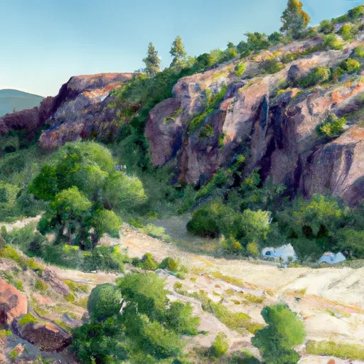
The campground has 11 campsites that can accommodate tents and RVs up to 30 feet in length. Amenities include picnic tables, fire rings, and vault toilets. Drinking water is available at the campground, but there are no electrical hookups.
Lower Lehman Creek camping area is situated at an elevation of 7,000 feet, which can result in cooler temperatures than the surrounding areas. The best time to visit the area is during the summer months, from June to September, when temperatures range from 60-90°F during the day and 40-60°F at night.
Interesting facts about the area include that Great Basin National Park is home to the oldest trees in the world, the Bristlecone Pines, which can live for thousands of years. The park is also known for its dark night skies, making it a great place for stargazing.
Overall, Lower Lehman Creek camping area is a picturesque and convenient spot to camp while exploring Great Basin National Park's natural wonders.
What's on-site at Lower Lehman Creek
Key facilities Snoflo tracks for this campground. Confirm with the operator before booking -- amenities can change seasonally.
Plan your trip down to the hour
Same weather feed Snoflo's iOS app uses -- updated continuously from NOAA / yr.no.
Next 5 days, hour by hour
Temperature line with weather symbols on top, snow + rain accumulation as columns, humidity as a dotted line.
5-day forecast table
Every 3 hours, broken out across temperature, snow, rain, humidity, and wind. Each cell is colour-coded relative to the column min/max so trends jump out at a glance.
| Time | Condition | Temp (°F) | Snow (in) | Rain (in) | Humidity (%) | Wind (mps) | Wind dir |
|---|---|---|---|---|---|---|---|
| Loading detailed forecast… | |||||||
15-day temperature & precipitation
Daily temperatures, snow, and rain projected over the next two weeks. Hover any point for the full breakdown.
Other campgrounds in the area
Snoflo-tracked campsites within driving distance of Lower Lehman Creek, with reservations status.
| Campground | Reservations | Toilets | View |
|---|---|---|---|
| Lower Lehman - Great Basin National Park | ✗ | ✓ | → |
| Upper Lehman - Great Basin National Park | ✗ | ✓ | → |
| Upper Lehman Creek | ✗ | ✗ | → |
| Grey Cliffs Campground | ✗ | ✗ | → |
| Baker Creek - Great Basin National Park | ✗ | ✓ | → |
Nearby streamflow
USGS streamgauges within reach of Lower Lehman Creek -- pulled live from the National Water Information System.
| Streamgauge | Discharge | View |
|---|---|---|
| Lehman Creek Near Baker | 4 cfs | → |
| Cleve C Nr Ely | 5 cfs | → |
| Steptoe C Nr Ely | 3 cfs | → |
| Water Canyon Cr Nr Preston Nv | 1 cfs | → |
| Preston Big Spring Nr Preston Nv | 7 cfs | → |
| Trout Creek Near Callao | 1 cfs | → |
Nearby snow depths
NRCS SNOTEL stations within reach of Lower Lehman Creek -- relevant when planning a shoulder-season or alpine trip.
| SNOTEL station | Snowpack | 24h Snowfall | View |
|---|---|---|---|
| Wheeler Peak | 0.0 in | 0.0 in | → |
| Nohrsc Wheeler Peak | 0.0 in | 0.0 in | → |
| 14k07 - Silver Ck #2 | 0.0 in | 0.0 in | → |
| Silver Creek Nv | 0.0 in | 0.0 in | → |
| Eskdale | 0.0 in | 0.0 in | → |
| Cave Mountain | 0.0 in | 0.0 in | → |
Plan a longer trip
The closest parks, lakes, boat launches, and paddle runs so a camping night can grow into a full weekend.
Parks
- Mount Moriah Wilderness
- Great Basin National Park
- High Schells Wilderness
- Highland Ridge Wilderness
- Cave Lake State Park
- Government Peak Wilderness
Camping essentials & Leave No Trace
- Pack it in, pack it out
- Take all trash, food scraps, and gear back with you to keep campsites clean and protect wildlife.
- Respect wildlife
- Observe animals from a distance, store food securely, and never feed wildlife to maintain natural behavior and safety.
- Know before you go
- Check weather, fire restrictions, trail conditions, and permit requirements to ensure a safe and well-planned trip.
- Minimize campfire impact
- Use established fire rings, keep fires small, fully extinguish them, or opt for a camp stove when fires are restricted.
- Leave what you find
- Preserve natural and cultural features by avoiding removal of plants, rocks, artifacts, or other elements of the environment.
Set push alerts in the Snoflo app
Save Lower Lehman Creek as a favorite, set a custom threshold (precipitation, snowpack, freezing temperatures), and the iOS app will push the moment conditions cross.
About Lower Lehman Creek
Can I make reservations at Lower Lehman Creek?
This campground does not appear to accept reservations -- it's typically first-come, first-served. Arrive early on summer weekends.
How fresh is the weather data on this page?
The hourly forecast updates throughout the day from the NOAA / yr.no public feeds. Streamflow data is pulled live from USGS streamgauges and snowpack from the NRCS SNOTEL network.
What's the best time of year to visit?
Use the 15-day temperature & precipitation outlook on this page to plan -- pick a window with comfortable temperatures and low precipitation. For longer trips, the 5-day hourly meteogram shows snow + rain accumulation hour-by-hour.
How do I get to Lower Lehman Creek?
Tap Directions in the hero above to open driving directions in Google Maps, or Open in map to center the Snoflo interactive map on the campground.
Can I get alerts when conditions change?
Yes -- alerts are managed through the Snoflo iOS app. Favorite this campground, set a threshold (temperature, snowpack, precipitation), and you'll get a push the moment it crosses.
Other campgrounds near here
Snoflo-tracked campgrounds within driving distance of Lower Lehman Creek.