Devils Tower Campground
Community Reviews
Been here? Share the conditions.
Reviews, ratings & photos are added in the free Snoflo iOS app — rate a spot, tag the conditions, and your visit is verified by location. Add or manage your reviews from the app.
Devils Tower
One of the closest points of interest to the campsite is the Owyhee River, which offers some of the best fly fishing in the state. Visitors can also explore the nearby Leslie Gulch Trail, which offers a scenic hike through the stunning rock formations. The area is also popular for off-roading and scenic drives.
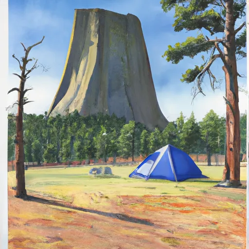
The Devils Tower Campsite is a primitive camping area, meaning there are no amenities like water or toilets. Visitors should come prepared with all necessary camping gear and supplies. The area is also known for its dark skies, making it an ideal location for stargazing.
The best time of year to visit the Devils Tower Campsite is in the spring and fall when temperatures are mild. Average temperatures in the spring (April to June) range from 50 to 70 degrees Fahrenheit, while temperatures in the fall (September to November) range from 40 to 65 degrees Fahrenheit.
In summary, the Devils Tower Campsite offers primitive camping with stunning surrounding views, nearby points of interest like the Owyhee River and Leslie Gulch Trail, and popular activities like off-roading and stargazing. The best time to visit is in the spring and fall, and visitors should come prepared with all necessary camping gear and supplies.
What's on-site at Devils Tower
Key facilities Snoflo tracks for this campground. Confirm with the operator before booking -- amenities can change seasonally.
Plan your trip down to the hour
Same weather feed Snoflo's iOS app uses -- updated continuously from NOAA / yr.no.
Next 5 days, hour by hour
Temperature line with weather symbols on top, snow + rain accumulation as columns, humidity as a dotted line.
5-day forecast table
Every 3 hours, broken out across temperature, snow, rain, humidity, and wind. Each cell is colour-coded relative to the column min/max so trends jump out at a glance.
| Time | Condition | Temp (°F) | Snow (in) | Rain (in) | Humidity (%) | Wind (mps) | Wind dir |
|---|---|---|---|---|---|---|---|
| Loading detailed forecast… | |||||||
15-day temperature & precipitation
Daily temperatures, snow, and rain projected over the next two weeks. Hover any point for the full breakdown.
Other campgrounds in the area
Snoflo-tracked campsites within driving distance of Devils Tower, with reservations status.
| Campground | Reservations | Toilets | View |
|---|---|---|---|
| Bobcat | ✗ | ✗ | → |
| Upper Greeley | ✗ | ✗ | → |
| Lower Greeley | ✗ | ✗ | → |
| Middle Greeley | ✗ | ✗ | → |
| Pothole Arch | ✗ | ✗ | → |
Nearby streamflow
USGS streamgauges within reach of Devils Tower -- pulled live from the National Water Information System.
| Streamgauge | Discharge | View |
|---|---|---|
| Owyhee River Nr Rome Or | 72 cfs | → |
| Owyhee River Below Owyhee Dam Or | 118 cfs | → |
| Malheur R Be Warmsprings Res Nr Riverside Or | 0 cfs | → |
| Boise River Nr Parma Id | 510 cfs | → |
| Dixie Drain Nr Wilder Id | 149 cfs | → |
| Sand Run Gulch Nr Parma Id | 119 cfs | → |
Nearby snow depths
NRCS SNOTEL stations within reach of Devils Tower -- relevant when planning a shoulder-season or alpine trip.
| SNOTEL station | Snowpack | 24h Snowfall | View |
|---|---|---|---|
| Reynolds Creek | 0.0 in | 0.0 in | → |
| Homedale 4.0 Wnw | 0.0 in | 0.0 in | → |
| Nohrsc Reynolds Creek | 0.0 in | 0.0 in | → |
| Homedale 1 Se | 0.0 in | 0.0 in | → |
| South Mtn. | 0.0 in | 0.0 in | → |
| South Mtn. | 0.0 in | 0.0 in | → |
Plan a longer trip
The closest parks, lakes, boat launches, and paddle runs so a camping night can grow into a full weekend.
Parks
Boat launches
Camping essentials & Leave No Trace
- Pack it in, pack it out
- Take all trash, food scraps, and gear back with you to keep campsites clean and protect wildlife.
- Respect wildlife
- Observe animals from a distance, store food securely, and never feed wildlife to maintain natural behavior and safety.
- Know before you go
- Check weather, fire restrictions, trail conditions, and permit requirements to ensure a safe and well-planned trip.
- Minimize campfire impact
- Use established fire rings, keep fires small, fully extinguish them, or opt for a camp stove when fires are restricted.
- Leave what you find
- Preserve natural and cultural features by avoiding removal of plants, rocks, artifacts, or other elements of the environment.
Set push alerts in the Snoflo app
Save Devils Tower as a favorite, set a custom threshold (precipitation, snowpack, freezing temperatures), and the iOS app will push the moment conditions cross.
About Devils Tower
Can I make reservations at Devils Tower?
This campground does not appear to accept reservations -- it's typically first-come, first-served. Arrive early on summer weekends.
How fresh is the weather data on this page?
The hourly forecast updates throughout the day from the NOAA / yr.no public feeds. Streamflow data is pulled live from USGS streamgauges and snowpack from the NRCS SNOTEL network.
What's the best time of year to visit?
Use the 15-day temperature & precipitation outlook on this page to plan -- pick a window with comfortable temperatures and low precipitation. For longer trips, the 5-day hourly meteogram shows snow + rain accumulation hour-by-hour.
How do I get to Devils Tower?
Tap Directions in the hero above to open driving directions in Google Maps, or Open in map to center the Snoflo interactive map on the campground.
Can I get alerts when conditions change?
Yes -- alerts are managed through the Snoflo iOS app. Favorite this campground, set a threshold (temperature, snowpack, precipitation), and you'll get a push the moment it crosses.
Other campgrounds near here
Snoflo-tracked campgrounds within driving distance of Devils Tower.