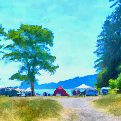
Paradise Point State Park Campground
Community Reviews
Been here? Share the conditions.
Reviews, ratings & photos are added in the free Snoflo iOS app — rate a spot, tag the conditions, and your visit is verified by location. Add or manage your reviews from the app.
Paradise Point State Park
Reservations are accepted at Paradise Point State Park, allowing visitors to secure their desired campsite in advance. This option is especially recommended during peak seasons when the campground tends to fill up quickly. The best time to visit is during the summer months when the weather is pleasant and ideal for outdoor activities such as hiking, fishing, and boating. However, it's worth noting that the campground is open year-round, and campers can enjoy the beauty of the park in every season.
While staying at Paradise Point State Park, campers can explore the park's stunning natural surroundings. The campground is nestled along the East Fork Lewis River, providing opportunities for fishing and observing wildlife. Hiking trails offer stunning views of the surrounding forests and river. However, caution should be exercised when hiking, as some trails can be steep and muddy. It is important to stay on designated paths and be mindful of any slippery or hazardous conditions. With its beautiful setting, amenities, and recreational opportunities, Paradise Point State Park is a wonderful destination for a camping adventure in Washington.
What's on-site at Paradise Point State Park
Key facilities Snoflo tracks for this campground. Confirm with the operator before booking -- amenities can change seasonally.
Plan your trip down to the hour
Same weather feed Snoflo's iOS app uses -- updated continuously from NOAA / yr.no.
Next 5 days, hour by hour
Temperature line with weather symbols on top, snow + rain accumulation as columns, humidity as a dotted line.
5-day forecast table
Every 3 hours, broken out across temperature, snow, rain, humidity, and wind. Each cell is colour-coded relative to the column min/max so trends jump out at a glance.
| Time | Condition | Temp (°F) | Snow (in) | Rain (in) | Humidity (%) | Wind (mps) | Wind dir |
|---|---|---|---|---|---|---|---|
| Loading detailed forecast… | |||||||
15-day temperature & precipitation
Daily temperatures, snow, and rain projected over the next two weeks. Hover any point for the full breakdown.
Other campgrounds in the area
Snoflo-tracked campsites within driving distance of Paradise Point State Park, with reservations status.
| Campground | Reservations | Toilets | View |
|---|---|---|---|
| Bayport Rv Park | ✗ | ✗ | → |
| Hike/Bike | ✗ | ✗ | → |
| Battle Ground Lake State Park | ✓ | ✗ | → |
| Louis Rasmussen Rv Park | ✗ | ✗ | → |
| Group Camp | ✗ | ✗ | → |
Nearby streamflow
USGS streamgauges within reach of Paradise Point State Park -- pulled live from the National Water Information System.
| Streamgauge | Discharge | View |
|---|---|---|
| Lewis River At Ariel | 1,410 cfs | → |
| East Fork Lewis River Near Heisson | 68 cfs | → |
| Burnt Bridge Creek Near Mouth At Vancouver | 37 cfs | → |
| Columbia Slough At Portland | 180 cfs | → |
| Canyon Creek Near Amboy | 32 cfs | → |
| Speelyai Creek Near Cougar | 5 cfs | → |
Nearby snow depths
NRCS SNOTEL stations within reach of Paradise Point State Park -- relevant when planning a shoulder-season or alpine trip.
| SNOTEL station | Snowpack | 24h Snowfall | View |
|---|---|---|---|
| Kelso-Longview Airport | 0.0 in | 0.0 in | → |
| Calamity | 0.0 in | 0.0 in | → |
| Hillsboro Airport Asos & Lawrs | 0.0 in | 0.0 in | → |
| Nohrsc Sheep Canyon | 0.0 in | 0.0 in | → |
| Sheep Canyon | 0.0 in | 0.0 in | → |
| Swift Creek | 2.0 in | 0.0 in | → |
Plan a longer trip
The closest parks, lakes, boat launches, and paddle runs so a camping night can grow into a full weekend.
Parks
- Paradise Point State Park
- Mud Lake Park
- La Center Community Park
- Horseshoe Lake Park
- Godffrey Park
- Heinie Heumann Park
Boat launches
- Paradise Point State Park
- South Pekin Road Cowlitz County
- Northwest La Center Road La Center
- Horseshoe Lake Park
- City Marina - Ridgefield
- St. Helens Marina
Points of interest
- Warrior Rock Lighthouse
- Seaman
- Cedar Creek Grist Mill
- Peace Candle Of The World
- Old Tractor
- Sunken Village Archeological Site
Paddle runs
- Headwaters In Sw 1/4 Of Sec 8, T4n, R6e To Gifford Pinchot Nf Boundary
- Nw1/4 Of Sec 9, T5n, R6e To Ne1/4 Of Sec 6, T5n, R5e
- Headwaters In Sw1/4 Sec 28, T9n, R5e To Mount St. Helens National Volcanic Monument Boundary
- Gifford Pinchot Nf Boundary To Maximum Pool Of Swift Reservoir In Nw1/4 Of Sec 35, T7n, R6e
- Nehalem River
- Confluence With Smith Creek To Confluence With Lewis River
Camping essentials & Leave No Trace
- Pack it in, pack it out
- Take all trash, food scraps, and gear back with you to keep campsites clean and protect wildlife.
- Respect wildlife
- Observe animals from a distance, store food securely, and never feed wildlife to maintain natural behavior and safety.
- Know before you go
- Check weather, fire restrictions, trail conditions, and permit requirements to ensure a safe and well-planned trip.
- Minimize campfire impact
- Use established fire rings, keep fires small, fully extinguish them, or opt for a camp stove when fires are restricted.
- Leave what you find
- Preserve natural and cultural features by avoiding removal of plants, rocks, artifacts, or other elements of the environment.
Set push alerts in the Snoflo app
Save Paradise Point State Park as a favorite, set a custom threshold (precipitation, snowpack, freezing temperatures), and the iOS app will push the moment conditions cross.
About Paradise Point State Park
Can I make reservations at Paradise Point State Park?
Yes -- this campground accepts reservations. Snoflo recommends booking early for peak season; check the operator (Recreation.gov / state park system / private operator) for the booking window and cancellation policy.
How fresh is the weather data on this page?
The hourly forecast updates throughout the day from the NOAA / yr.no public feeds. Streamflow data is pulled live from USGS streamgauges and snowpack from the NRCS SNOTEL network.
What's the best time of year to visit?
Use the 15-day temperature & precipitation outlook on this page to plan -- pick a window with comfortable temperatures and low precipitation. For longer trips, the 5-day hourly meteogram shows snow + rain accumulation hour-by-hour.
How do I get to Paradise Point State Park?
Tap Directions in the hero above to open driving directions in Google Maps, or Open in map to center the Snoflo interactive map on the campground.
Can I get alerts when conditions change?
Yes -- alerts are managed through the Snoflo iOS app. Favorite this campground, set a threshold (temperature, snowpack, precipitation), and you'll get a push the moment it crosses.
Other campgrounds near here
Snoflo-tracked campgrounds within driving distance of Paradise Point State Park.