Steelhead Falls Campground Campground
Community Reviews
Been here? Share the conditions.
Reviews, ratings & photos are added in the free Snoflo iOS app — rate a spot, tag the conditions, and your visit is verified by location. Add or manage your reviews from the app.
Steelhead Falls Campground
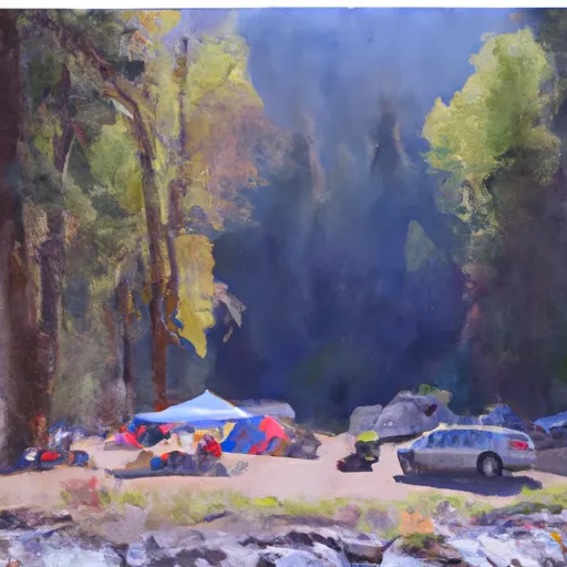
Reservations are not accepted at Steelhead Falls Campground, as it operates on a first-come, first-served basis. This means that campers should plan their visit accordingly and arrive early to secure a spot, especially during peak seasons. The best time to visit this camping area is during the spring and fall when the weather is mild, and the area is less crowded. Summer can be quite hot, so it is advisable to bring plenty of water and sun protection.
Steelhead Falls Campground offers various attractions and activities for visitors to enjoy. One major highlight is the stunning Steelhead Falls, located nearby. This impressive 20-foot waterfall is a must-see, providing a picturesque backdrop for hiking, photography, and picnicking. It is important to exercise caution while hiking in the area, as some trails can be steep and slippery. Additionally, anglers will be pleased to know that the nearby Deschutes River offers excellent fishing opportunities.
In conclusion, Steelhead Falls Campground in Oregon is a lovely camping destination, providing basic amenities and a serene atmosphere. Campers should plan their visit during the spring or fall, bring their own water, and be cautious while exploring the beautiful Steelhead Falls and hiking trails in the area.
What's on-site at Steelhead Falls Campground
Key facilities Snoflo tracks for this campground. Confirm with the operator before booking -- amenities can change seasonally.
Plan your trip down to the hour
Same weather feed Snoflo's iOS app uses -- updated continuously from NOAA / yr.no.
Next 5 days, hour by hour
Temperature line with weather symbols on top, snow + rain accumulation as columns, humidity as a dotted line.
5-day forecast table
Every 3 hours, broken out across temperature, snow, rain, humidity, and wind. Each cell is colour-coded relative to the column min/max so trends jump out at a glance.
| Time | Condition | Temp (°F) | Snow (in) | Rain (in) | Humidity (%) | Wind (mps) | Wind dir |
|---|---|---|---|---|---|---|---|
| Loading detailed forecast… | |||||||
15-day temperature & precipitation
Daily temperatures, snow, and rain projected over the next two weeks. Hover any point for the full breakdown.
Other campgrounds in the area
Snoflo-tracked campsites within driving distance of Steelhead Falls Campground, with reservations status.
| Campground | Reservations | Toilets | View |
|---|---|---|---|
| Crooked River Ranch Rv Park | ✗ | ✗ | → |
| Henderson Flats Camp Site | ✗ | ✗ | → |
| Haystack West Shore Campground And Day Use Area | ✗ | ✗ | → |
| Haystack South Shore Group Campground | ✗ | ✗ | → |
Nearby streamflow
USGS streamgauges within reach of Steelhead Falls Campground -- pulled live from the National Water Information System.
| Streamgauge | Discharge | View |
|---|---|---|
| Crooked River Blw Osborne Canyon | 129 cfs | → |
| Crooked River Below Opal Springs | 1,160 cfs | → |
| Deschutes River Near Culver | 518 cfs | → |
| Metolius River Near Grandview | 1,240 cfs | → |
| Deschutes River Near Madras | 3,620 cfs | → |
| Shitike Creek Near Warm Springs | 42 cfs | → |
Nearby snow depths
NRCS SNOTEL stations within reach of Steelhead Falls Campground -- relevant when planning a shoulder-season or alpine trip.
| SNOTEL station | Snowpack | 24h Snowfall | View |
|---|---|---|---|
| Bend 7 Ne | 0.0 in | 0.0 in | → |
| Three Creeks Meadow | 0.0 in | 0.0 in | → |
| Three Creeks Meadow | 0.0 in | 0.0 in | → |
| Hogg Pass | 0.0 in | 0.0 in | → |
| Nohrsc Hogg Pass | 0.0 in | 0.0 in | → |
| Hoodoo Butte - Snow | 0.0 in | 0.0 in | → |
Plan a longer trip
The closest parks, lakes, boat launches, and paddle runs so a camping night can grow into a full weekend.
Parks
- Peter Skene Ogden State Scenic Viewpoint
- The Cove Palisades State Park
- Smith Rock State Park
- Quince Park
- Cline Falls State Scenic Viewpoint
- Fairhaven Park
Boat launches
- Cove Palisades - Upper Deschutes
- Haystack West
- Haystack Campground
- Cove Palisades - Lower Deschutes
- Crooked River
- Cove Palisades Marina
Points of interest
- Oregon Trunk Railroad Bridge
- Crooked River High Bridge
- Rex T. Barber Veterans Memorial Bridge
- Opal Canyon Overlook
- Crescent Moon Ranch
- The Art Of Alfred A. Dolezal Gallery
Paddle runs
- Canyon Run (Lower Bridge To Billy Chinook Res.)
- Crooked River National Grassland Boundary To Confluence With Deschutes River
- Cline Falls State Park To Lower Bridge
- Source To Confluence With Metolius River
- Tumalo State Park To Cline Falls State Park
- Bend To Tumalo State Park (Riverhouse Run)
Camping essentials & Leave No Trace
- Pack it in, pack it out
- Take all trash, food scraps, and gear back with you to keep campsites clean and protect wildlife.
- Respect wildlife
- Observe animals from a distance, store food securely, and never feed wildlife to maintain natural behavior and safety.
- Know before you go
- Check weather, fire restrictions, trail conditions, and permit requirements to ensure a safe and well-planned trip.
- Minimize campfire impact
- Use established fire rings, keep fires small, fully extinguish them, or opt for a camp stove when fires are restricted.
- Leave what you find
- Preserve natural and cultural features by avoiding removal of plants, rocks, artifacts, or other elements of the environment.
Set push alerts in the Snoflo app
Save Steelhead Falls Campground as a favorite, set a custom threshold (precipitation, snowpack, freezing temperatures), and the iOS app will push the moment conditions cross.
About Steelhead Falls Campground
Can I make reservations at Steelhead Falls Campground?
This campground does not appear to accept reservations -- it's typically first-come, first-served. Arrive early on summer weekends.
How fresh is the weather data on this page?
The hourly forecast updates throughout the day from the NOAA / yr.no public feeds. Streamflow data is pulled live from USGS streamgauges and snowpack from the NRCS SNOTEL network.
What's the best time of year to visit?
Use the 15-day temperature & precipitation outlook on this page to plan -- pick a window with comfortable temperatures and low precipitation. For longer trips, the 5-day hourly meteogram shows snow + rain accumulation hour-by-hour.
How do I get to Steelhead Falls Campground?
Tap Directions in the hero above to open driving directions in Google Maps, or Open in map to center the Snoflo interactive map on the campground.
Can I get alerts when conditions change?
Yes -- alerts are managed through the Snoflo iOS app. Favorite this campground, set a threshold (temperature, snowpack, precipitation), and you'll get a push the moment it crosses.
Other campgrounds near here
Snoflo-tracked campgrounds within driving distance of Steelhead Falls Campground.