Haystack West Boat Launch
Community Reviews
Been here? Share the conditions.
Reviews, ratings & photos are added in the free Snoflo iOS app — rate a spot, tag the conditions, and your visit is verified by location. Add or manage your reviews from the app.
Haystack West
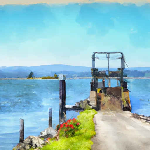
Based on the latest information available, the boat ramp named Haystack West is located in central Oregon, near the town of Sisters. It is a popular launching point for boaters looking to access the nearby Suttle Lake, which is a popular spot for fishing, waterskiing, and other water-based activities.
The boat ramp is reportedly a single-lane concrete ramp that is approximately 30 feet wide, with a gentle slope that allows for easy launching and retrieval of boats. It is also equipped with a courtesy dock that can be used for loading and unloading passengers and gear.
As for the types of craft that are permitted on Suttle Lake, the latest information indicates that motorized boats are allowed, but there are restrictions on the size of the motor and the speed at which they can travel. Additionally, non-motorized watercraft such as canoes, kayaks, and paddleboards are also allowed on the lake.
Overall, the Haystack West boat ramp appears to be a popular and well-maintained launching point for boaters visiting the Suttle Lake area. However, it is always important to check for any updates or changes to regulations before planning a trip to this or any other body of water.
Plan your launch down to the hour
Same weather feed Snoflo's iOS app uses -- updated continuously from NOAA / yr.no.
Next 5 days, hour by hour
Temperature line with weather symbols on top, snow + rain accumulation as columns, humidity as a dotted line.
5-day forecast table
Every 3 hours, broken out across temperature, snow, rain, humidity, and wind.
| Time | Condition | Temp (°F) | Snow (in) | Rain (in) | Humidity (%) | Wind (mps) | Wind dir |
|---|---|---|---|---|---|---|---|
| Loading detailed forecast… | |||||||
15-day temperature & precipitation
Daily temperatures, snow, and rain projected over the next two weeks.
Area streamflow levels
USGS streamgauges around Haystack West -- the same readings that determine whether your launch is safe and your boat is the right craft.
| Streamgauge | Discharge | View |
|---|---|---|
| Crooked River Blw Osborne Canyon | 101 cfs | → |
| Crooked River Below Opal Springs | 1,110 cfs | → |
| Deschutes River Near Culver | 518 cfs | → |
| Deschutes River Near Madras | 3,660 cfs | → |
| Metolius River Near Grandview | 1,240 cfs | → |
| Shitike Creek Near Warm Springs | 38 cfs | → |
Plan a longer trip
The closest paddle runs, fishing spots, and other boat launches so you can extend a day on the water.
River runs
- Crooked River National Grassland Boundary To Confluence With Deschutes River
- Canyon Run (Lower Bridge To Billy Chinook Res.)
- Cline Falls State Park To Lower Bridge
- Warm Springs To Sherars Falls
- Source To Confluence With Metolius River
- Tumalo State Park To Cline Falls State Park
Boating safety & etiquette
- Check the conditions before you launch
- Use the streamflow numbers, weather, and wind forecast on this page. High-cfs whitewater requires whitewater-specific craft and skill.
- Wear your life jacket
- Statistically the single biggest survival factor in a boating incident. State law often requires one per passenger.
- File a float plan
- Tell someone on shore your put-in, take-out, and expected return time. Especially for multi-day or remote trips.
- Yield at the ramp
- Prep gear in the parking lot, not on the ramp. Launch and clear quickly so others can use the lane.
- Clean, drain, dry
- Inspect, clean, drain and dry your boat between waters to prevent the spread of aquatic invasive species.
Set push alerts in the Snoflo app
Save Haystack West as a favorite, set a discharge threshold or a wind/precipitation alert, and the iOS app will push the moment conditions cross.
About Haystack West
Can I launch a motorboat here?
Most Snoflo-tracked launches support motorboats; check the operator for any horsepower restrictions, paddle-only zones, or seasonal closures.
How fresh is the streamflow data?
USGS streamgauges report continuously (every 15 minutes); the table on this page pulls the latest reading at page load.
Is there a fee?
Many federal and state boat launches charge a day-use fee. Check the operator's site before driving out.
What boat is right for these conditions?
Use the nearby streamflow numbers and river-run panel on this page to gauge current conditions. Wider, slower water is friendly for casual paddling and powerboats; high-cfs whitewater requires whitewater-specific craft and skill.
Can I get alerts when conditions change?
Yes -- alerts are managed in the Snoflo iOS app. Favorite this launch, set a threshold (discharge, wind), and you'll get a push the moment it crosses.
Other launches near here
Snoflo-tracked boat launches within driving distance of Haystack West.