Yellowbottom Campground
Community Reviews
Been here? Share the conditions.
Reviews, ratings & photos are added in the free Snoflo iOS app — rate a spot, tag the conditions, and your visit is verified by location. Add or manage your reviews from the app.
Yellowbottom
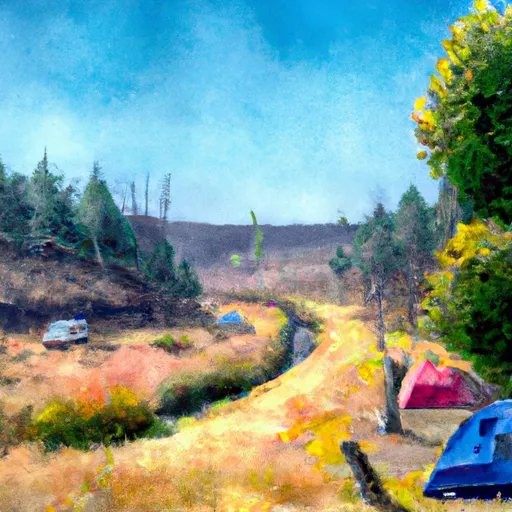
Reservations are not accepted at Yellowbottom camping area, making it a first-come, first-served campground. Therefore, it is advisable to arrive early to secure a spot, especially during peak camping seasons. The best time to visit this camping area is during the summer months when the weather is pleasant and ideal for outdoor activities.
While planning a trip to Yellowbottom camping area, it is important to be aware of a few considerations. Firstly, the campground does not offer potable water, so campers should bring their own or ensure they have a method to purify water from natural sources. Secondly, it is crucial to practice proper food storage and waste disposal to minimize interactions with wildlife. Lastly, it is advisable to check for any fire restrictions or warnings issued by local authorities before starting a campfire.
In summary, Yellowbottom camping area in Oregon offers a serene and picturesque camping experience. With its basic amenities, beautiful natural surroundings, and nearby recreational activities, it is an ideal destination for campers seeking a peaceful escape. However, it is necessary to arrive early, especially during peak seasons, and be mindful of water sources, wildlife interactions, and fire restrictions.
What's on-site at Yellowbottom
Key facilities Snoflo tracks for this campground. Confirm with the operator before booking -- amenities can change seasonally.
Plan your trip down to the hour
Same weather feed Snoflo's iOS app uses -- updated continuously from NOAA / yr.no.
Next 5 days, hour by hour
Temperature line with weather symbols on top, snow + rain accumulation as columns, humidity as a dotted line.
5-day forecast table
Every 3 hours, broken out across temperature, snow, rain, humidity, and wind. Each cell is colour-coded relative to the column min/max so trends jump out at a glance.
| Time | Condition | Temp (°F) | Snow (in) | Rain (in) | Humidity (%) | Wind (mps) | Wind dir |
|---|---|---|---|---|---|---|---|
| Loading detailed forecast… | |||||||
15-day temperature & precipitation
Daily temperatures, snow, and rain projected over the next two weeks. Hover any point for the full breakdown.
Other campgrounds in the area
Snoflo-tracked campsites within driving distance of Yellowbottom, with reservations status.
| Campground | Reservations | Toilets | View |
|---|---|---|---|
| Yellowbottom Recreation Site | ✗ | ✗ | → |
| Old Miners Meadow Group Use Area | ✗ | ✗ | → |
| Whitcomb Creek | ✗ | ✗ | → |
| Santiam Horse Camp | ✗ | ✗ | → |
| Whitcomb Creek Group Camp | ✗ | ✗ | → |
Nearby streamflow
USGS streamgauges within reach of Yellowbottom -- pulled live from the National Water Information System.
| Streamgauge | Discharge | View |
|---|---|---|
| Quartzville Creek Near Cascadia | 33 cfs | → |
| Schafer Creek Near Lacomb | 0 cfs | → |
| North Santiam River At Niagara | 1,020 cfs | → |
| Blowout Creek Near Detroit | 8 cfs | → |
| South Santiam River Below Cascadia | 84 cfs | → |
| No Santiam R Blw Boulder Crk | 430 cfs | → |
Nearby snow depths
NRCS SNOTEL stations within reach of Yellowbottom -- relevant when planning a shoulder-season or alpine trip.
| SNOTEL station | Snowpack | 24h Snowfall | View |
|---|---|---|---|
| Little Meadows | 0.0 in | 0.0 in | → |
| Little Meadows | 0.0 in | 0.0 in | → |
| Daly Lake | 0.0 in | 0.0 in | → |
| Jump Off Joe | 1.0 in | 1.0 in | → |
| Nohrsc Jump Off Joe | 2.0 in | 0.0 in | → |
| Foster Dam | 0.0 in | 0.0 in | → |
Plan a longer trip
The closest parks, lakes, boat launches, and paddle runs so a camping night can grow into a full weekend.
Parks
- Whitcomb Creek Park
- Wilderness Middle Santiam
- Santiam State Forest
- Minto County Park
- Detroit Lake- Mongold Wayside
- Detroit Lake State Recreation Area
Boat launches
Points of interest
- Quartzville Back Country Byway Kiosk
- Natural Rock Arch
- Phantom Natural Bridge
- High Deck Road
- Coffin Mountain Lookout
- Three Pools
Paddle runs
- Confluence With Unnamed Creek West Of Bruler To Willamette Nf Boundary
- Middle Santiam Wilderness Boundary To Willamette Nf Boundary
- Middle Santiam River
- Headwaters To Confluence With Unnamed Creek West Of Bruler Creek
- Packsaddle County Park To Mill City
- West Section Line Of Sec 31, T12s, R6e To Middle Santiam Wilderness Boundary
Camping essentials & Leave No Trace
- Pack it in, pack it out
- Take all trash, food scraps, and gear back with you to keep campsites clean and protect wildlife.
- Respect wildlife
- Observe animals from a distance, store food securely, and never feed wildlife to maintain natural behavior and safety.
- Know before you go
- Check weather, fire restrictions, trail conditions, and permit requirements to ensure a safe and well-planned trip.
- Minimize campfire impact
- Use established fire rings, keep fires small, fully extinguish them, or opt for a camp stove when fires are restricted.
- Leave what you find
- Preserve natural and cultural features by avoiding removal of plants, rocks, artifacts, or other elements of the environment.
Set push alerts in the Snoflo app
Save Yellowbottom as a favorite, set a custom threshold (precipitation, snowpack, freezing temperatures), and the iOS app will push the moment conditions cross.
About Yellowbottom
Can I make reservations at Yellowbottom?
This campground does not appear to accept reservations -- it's typically first-come, first-served. Arrive early on summer weekends.
How fresh is the weather data on this page?
The hourly forecast updates throughout the day from the NOAA / yr.no public feeds. Streamflow data is pulled live from USGS streamgauges and snowpack from the NRCS SNOTEL network.
What's the best time of year to visit?
Use the 15-day temperature & precipitation outlook on this page to plan -- pick a window with comfortable temperatures and low precipitation. For longer trips, the 5-day hourly meteogram shows snow + rain accumulation hour-by-hour.
How do I get to Yellowbottom?
Tap Directions in the hero above to open driving directions in Google Maps, or Open in map to center the Snoflo interactive map on the campground.
Can I get alerts when conditions change?
Yes -- alerts are managed through the Snoflo iOS app. Favorite this campground, set a threshold (temperature, snowpack, precipitation), and you'll get a push the moment it crosses.
Other campgrounds near here
Snoflo-tracked campgrounds within driving distance of Yellowbottom.