Gibson Gap campground
Community Reviews
Been here? Share the conditions.
Reviews, ratings & photos are added in the free Snoflo iOS app — rate a spot, tag the conditions, and your visit is verified by location. Add or manage your reviews from the app.
Gibson Gap
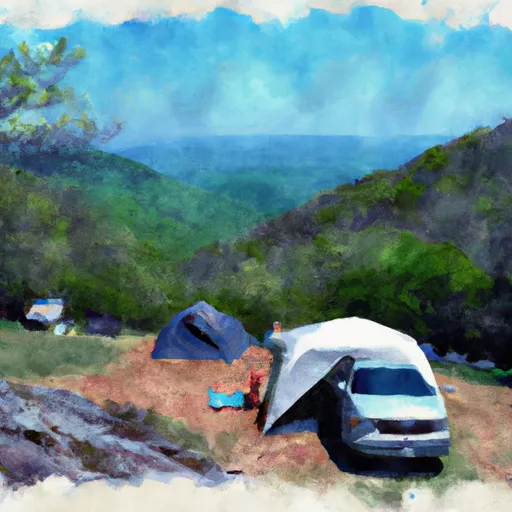
Surrounding Views:
The Gibson Gap camping area is nestled in a forested area with stunning mountain views. Visitors can enjoy the scenic views of the Great Smoky Mountains National Park right from their campsites.
Points of Interest:
The campground is located near several points of interest, including the Cades Cove Loop Road, which takes visitors on a scenic drive through a historic settlement area. Visitors can also access the Abrams Falls Trailhead, which leads to a picturesque waterfall.
Campground Amenities:
The Gibson Gap camping area offers several amenities to visitors, including picnic tables, fire rings, and access to restroom facilities. However, there is no potable water available at the campground, so visitors should bring their own supply.
Interesting Facts:
The Great Smoky Mountains National Park is home to over 10,000 species of plants and animals, making it one of the most biodiverse areas in the United States. Additionally, the park is a UNESCO World Heritage Site and is designated as an International Biosphere Reserve.
Best Time to Visit:
The best time to visit the Gibson Gap camping area is during the fall months, from September to November, when the weather is mild, and the leaves are changing colors. Average temperatures during this time range from the mid-50s to the mid-70s Fahrenheit. However, visitors should be prepared for cooler temperatures at night.
Sources:
- National Park Service. (n.d.). Gibson Gap Campground. https://www.nps.gov/grsm/planyourvisit/camping.htm
- Tennessean. (2021, April 22). Great Smoky Mountains National Park: Everything you need to know. https://www.tennessean.com/story/travel/2021/04/22/great-smoky-mountains-national-park-tennessee-guide-things-to-do/7303191002/
What's on-site at Gibson Gap
Key facilities Snoflo tracks for this campground. Confirm with the operator before booking -- amenities can change seasonally.
Plan your trip down to the hour
Same weather feed Snoflo's iOS app uses -- updated continuously from NOAA / yr.no.
Next 5 days, hour by hour
Temperature line with weather symbols on top, snow + rain accumulation as columns, humidity as a dotted line.
5-day forecast table
Every 3 hours, broken out across temperature, snow, rain, humidity, and wind. Each cell is colour-coded relative to the column min/max so trends jump out at a glance.
| Time | Condition | Temp (°F) | Snow (in) | Rain (in) | Humidity (%) | Wind (mps) | Wind dir |
|---|---|---|---|---|---|---|---|
| Loading detailed forecast… | |||||||
15-day temperature & precipitation
Daily temperatures, snow, and rain projected over the next two weeks. Hover any point for the full breakdown.
Other campgrounds in the area
Snoflo-tracked campsites within driving distance of Gibson Gap, with reservations status.
| Campground | Reservations | Toilets | View |
|---|---|---|---|
| Wilderness Road - Cumberland Gap National Park | ✗ | ✓ | → |
| Martins Fork Cabin | ✗ | ✗ | → |
| Pine Mountain State Park | ✗ | ✗ | → |
| Bunch Hollow Campground & Resort | ✗ | ✗ | → |
| Camp Cargill | ✗ | ✗ | → |
Nearby streamflow
USGS streamgauges within reach of Gibson Gap -- pulled live from the National Water Information System.
| Streamgauge | Discharge | View |
|---|---|---|
| Powell River Near Arthur | 1,160 cfs | → |
| Martins Fork Above Smith | 29 cfs | → |
| Clinch River Above Tazewell | 2,520 cfs | → |
| Cumberland River Near Harlan | 341 cfs | → |
| Martins Fork Near Smith | 102 cfs | → |
| Clear Fork At Saxton | 681 cfs | → |
Plan a longer trip
The closest parks, lakes, boat launches, and paddle runs so a camping night can grow into a full weekend.
Parks
- Shillalah Creek Wildlife Management Area
- Wilderness Road State Park
- Cumberland Gap National Historical Park
- Corrigan Wildlife Management Area
- Pine Mountain State Resort Park
- Nature Preserve Pine Mountain State Park
Boat launches
Camping essentials & Leave No Trace
- Pack it in, pack it out
- Take all trash, food scraps, and gear back with you to keep campsites clean and protect wildlife.
- Respect wildlife
- Observe animals from a distance, store food securely, and never feed wildlife to maintain natural behavior and safety.
- Know before you go
- Check weather, fire restrictions, trail conditions, and permit requirements to ensure a safe and well-planned trip.
- Minimize campfire impact
- Use established fire rings, keep fires small, fully extinguish them, or opt for a camp stove when fires are restricted.
- Leave what you find
- Preserve natural and cultural features by avoiding removal of plants, rocks, artifacts, or other elements of the environment.
Set push alerts in the Snoflo app
Save Gibson Gap as a favorite, set a custom threshold (precipitation, snowpack, freezing temperatures), and the iOS app will push the moment conditions cross.
About Gibson Gap
Can I make reservations at Gibson Gap?
This campground does not appear to accept reservations -- it's typically first-come, first-served. Arrive early on summer weekends.
How fresh is the weather data on this page?
The hourly forecast updates throughout the day from the NOAA / yr.no public feeds. Streamflow data is pulled live from USGS streamgauges and snowpack from the NRCS SNOTEL network.
What's the best time of year to visit?
Use the 15-day temperature & precipitation outlook on this page to plan -- pick a window with comfortable temperatures and low precipitation. For longer trips, the 5-day hourly meteogram shows snow + rain accumulation hour-by-hour.
How do I get to Gibson Gap?
Tap Directions in the hero above to open driving directions in Google Maps, or Open in map to center the Snoflo interactive map on the campground.
Can I get alerts when conditions change?
Yes -- alerts are managed through the Snoflo iOS app. Favorite this campground, set a threshold (temperature, snowpack, precipitation), and you'll get a push the moment it crosses.
Other campgrounds near here
Snoflo-tracked campgrounds within driving distance of Gibson Gap.