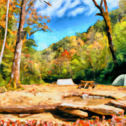
Tumbling Creek campground
Community Reviews
Been here? Share the conditions.
Reviews, ratings & photos are added in the free Snoflo iOS app — rate a spot, tag the conditions, and your visit is verified by location. Add or manage your reviews from the app.
Tumbling Creek
There are several nearby points of interest, including hiking trails, fishing spots, and scenic drives. The Bald River Falls and the Tellico River are just a short drive away, offering visitors stunning views of cascading waterfalls and crystal-clear waters.
The campground offers several amenities, including picnic tables, fire rings, and vault toilets. There are a total of 17 campsites available on a first-come, first-served basis, so visitors should plan accordingly.
One quirky fact about Tumbling Creek is that it is located near the site of the former town of Tallassee, which was abandoned in the early 1900s after a devastating flood.
The best time of year to visit Tumbling Creek is during the spring and fall months, when the temperatures are mild and the foliage is at its most vibrant. Average temperatures during this time range from the mid-50s to mid-70s. Visitors should be aware of potential inclement weather during the winter months, as the campground is subject to heavy snowfall and icy conditions.
What's on-site at Tumbling Creek
Key facilities Snoflo tracks for this campground. Confirm with the operator before booking -- amenities can change seasonally.
Plan your trip down to the hour
Same weather feed Snoflo's iOS app uses -- updated continuously from NOAA / yr.no.
Next 5 days, hour by hour
Temperature line with weather symbols on top, snow + rain accumulation as columns, humidity as a dotted line.
5-day forecast table
Every 3 hours, broken out across temperature, snow, rain, humidity, and wind. Each cell is colour-coded relative to the column min/max so trends jump out at a glance.
| Time | Condition | Temp (°F) | Snow (in) | Rain (in) | Humidity (%) | Wind (mps) | Wind dir |
|---|---|---|---|---|---|---|---|
| Loading detailed forecast… | |||||||
15-day temperature & precipitation
Daily temperatures, snow, and rain projected over the next two weeks. Hover any point for the full breakdown.
Other campgrounds in the area
Snoflo-tracked campsites within driving distance of Tumbling Creek, with reservations status.
| Campground | Reservations | Toilets | View |
|---|---|---|---|
| Tumbling Creek Campground | ✗ | ✗ | → |
| Thunder Rock | ✗ | ✗ | → |
| Thunder Rock Campground | ✗ | ✗ | → |
| Sylco Campground | ✗ | ✗ | → |
| Sylco | ✗ | ✗ | → |
Nearby streamflow
USGS streamgauges within reach of Tumbling Creek -- pulled live from the National Water Information System.
| Streamgauge | Discharge | View |
|---|---|---|
| Ocoee River At Copperhill | 471 cfs | → |
| Mill Creek Near Crandall | 12 cfs | → |
| Toccoa River Near Dial | 276 cfs | → |
| Cartecay River Near Ellijay | 161 cfs | → |
| Coosawattee River Near Ellijay | 297 cfs | → |
| Oostanaula Creek Near Sanford | 40 cfs | → |
Plan a longer trip
The closest parks, lakes, boat launches, and paddle runs so a camping night can grow into a full weekend.
Parks
- Wilderness Big Frog
- Wilderness Cohutta
- Wilderness Little Frog Mountain
- Wilderness Gee Creek
- Preserve Holly Creek
- Wilderness Rich Mountain
Boat launches
- Toccoa Avenue 104, Mccaysville
- Horseshoe Bend Park
- Curtis Switch Boat Launch
- East Parksville
- West Parksville
- Lake Ocoee Marina
Fishing spots
Points of interest
- Prayer Mountain
- Arise And Shine Marker
- Ten Commandments
- Garden Tomb
- Golgotha Hill
- Fields Of The Wood
Paddle runs
- Southern Boundary Cohutta Wilderness Near Peter Cove To Northern Boundary Cohutta Wilderness Near Alaculsy
- Northern Boundary Cohutta Wilderness To Confluence With Conasauga River
- Nf Boundary To Taylor's Creek In Cherokee Nf (Tn)
- Source In Cohutta Wilderness To Nf Boundary North Of Murray's Lake
- Taylors Creek (Rm 74.5) To Nf Boundary (Rm 70.0)
- Apalachia Powerhouse (Rm 53.5) To Us411 Bridge (Rm 43.0)
Camping essentials & Leave No Trace
- Pack it in, pack it out
- Take all trash, food scraps, and gear back with you to keep campsites clean and protect wildlife.
- Respect wildlife
- Observe animals from a distance, store food securely, and never feed wildlife to maintain natural behavior and safety.
- Know before you go
- Check weather, fire restrictions, trail conditions, and permit requirements to ensure a safe and well-planned trip.
- Minimize campfire impact
- Use established fire rings, keep fires small, fully extinguish them, or opt for a camp stove when fires are restricted.
- Leave what you find
- Preserve natural and cultural features by avoiding removal of plants, rocks, artifacts, or other elements of the environment.
Set push alerts in the Snoflo app
Save Tumbling Creek as a favorite, set a custom threshold (precipitation, snowpack, freezing temperatures), and the iOS app will push the moment conditions cross.
About Tumbling Creek
Can I make reservations at Tumbling Creek?
This campground does not appear to accept reservations -- it's typically first-come, first-served. Arrive early on summer weekends.
How fresh is the weather data on this page?
The hourly forecast updates throughout the day from the NOAA / yr.no public feeds. Streamflow data is pulled live from USGS streamgauges and snowpack from the NRCS SNOTEL network.
What's the best time of year to visit?
Use the 15-day temperature & precipitation outlook on this page to plan -- pick a window with comfortable temperatures and low precipitation. For longer trips, the 5-day hourly meteogram shows snow + rain accumulation hour-by-hour.
How do I get to Tumbling Creek?
Tap Directions in the hero above to open driving directions in Google Maps, or Open in map to center the Snoflo interactive map on the campground.
Can I get alerts when conditions change?
Yes -- alerts are managed through the Snoflo iOS app. Favorite this campground, set a threshold (temperature, snowpack, precipitation), and you'll get a push the moment it crosses.
Other campgrounds near here
Snoflo-tracked campgrounds within driving distance of Tumbling Creek.