Upper Six Mile Ponds Campground
Community Reviews
Been here? Share the conditions.
Reviews, ratings & photos are added in the free Snoflo iOS app — rate a spot, tag the conditions, and your visit is verified by location. Add or manage your reviews from the app.
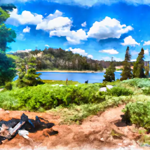
Upper Six Mile Ponds
The campground provides amenities such as picnic tables, fire rings, and vault toilets. It is a first-come, first-serve campground with 23 campsites available. An interesting fact about the area is that it is home to a diverse range of wildlife, including black bears, mountain lions, and moose.
The best time of year to visit is during the summer months, from June to September, when temperatures range from the mid-60s to mid-80s Fahrenheit. Visitors can enjoy hiking, fishing, and wildlife watching during this time. It is important to note that the campground is only accessible by a dirt road, which may be closed during the winter months due to snow. Overall, the Upper Six Mile Ponds Camping Area is a beautiful destination for nature lovers looking to escape the hustle and bustle of city life.
What's on-site at Upper Six Mile Ponds
Key facilities Snoflo tracks for this campground. Confirm with the operator before booking -- amenities can change seasonally.
Plan your trip down to the hour
Same weather feed Snoflo's iOS app uses -- updated continuously from NOAA / yr.no.
Next 5 days, hour by hour
Temperature line with weather symbols on top, snow + rain accumulation as columns, humidity as a dotted line.
5-day forecast table
Every 3 hours, broken out across temperature, snow, rain, humidity, and wind. Each cell is colour-coded relative to the column min/max so trends jump out at a glance.
| Time | Condition | Temp (°F) | Snow (in) | Rain (in) | Humidity (%) | Wind (mps) | Wind dir |
|---|---|---|---|---|---|---|---|
| Loading detailed forecast… | |||||||
15-day temperature & precipitation
Daily temperatures, snow, and rain projected over the next two weeks. Hover any point for the full breakdown.
Other campgrounds in the area
Snoflo-tracked campsites within driving distance of Upper Six Mile Ponds, with reservations status.
| Campground | Reservations | Toilets | View |
|---|---|---|---|
| Riverbend County Park | ✗ | ✗ | → |
| Uchee Creek Military | ✓ | ✗ | → |
| Bluff Creek | ✓ | ✗ | → |
| Florence Marina State Park | ✓ | ✗ | → |
| Lakepoint State Park | ✓ | ✗ | → |
| Spring Villa Campground | ✗ | ✗ | → |
Nearby streamflow
USGS streamgauges within reach of Upper Six Mile Ponds -- pulled live from the National Water Information System.
| Streamgauge | Discharge | View |
|---|---|---|
| Manti Creek Below Dugway Creek | 5 cfs | → |
| Ephraim Tunnel Near Ephraim | 0 cfs | → |
| Sevier River Blw San Pitch River | 17 cfs | → |
| Ferron Creek (Upper Station) Near Ferron | 23 cfs | → |
| Salina Creek Near Emery | 11 cfs | → |
| Ferron Cr Bl Millsite Res & Divs Nr Ferron | · | → |
Nearby snow depths
NRCS SNOTEL stations within reach of Upper Six Mile Ponds -- relevant when planning a shoulder-season or alpine trip.
| SNOTEL station | Snowpack | 24h Snowfall | View |
|---|---|---|---|
| Beaver Dams | 0.0 in | 0.0 in | → |
| Nohrsc 11k35 - Thistle Flat | 1.0 in | 0.0 in | → |
| Mt Baldy | 0.0 in | 0.0 in | → |
| Beaver Dams | 0.0 in | 0.0 in | → |
| Thistle Flat | 0.0 in | 0.0 in | → |
| 11k12 - Mt. Baldy R.S. Snow Course | 0.0 in | 0.0 in | → |
Plan a longer trip
The closest parks, lakes, boat launches, and paddle runs so a camping night can grow into a full weekend.
Parks
- Chattahoochee Indian Cultural Center
- Lindsey Creek Park
- State Park Providence Canyon
- Rigdon Park
- Benning Park
- Primus E King Recreation Park
Boat launches
- River Bend Park Road Chattahoochee County
- Uchee Creek
- Bluff Creek Landing
- Chubcreek Road Russell County
- Florence Marina State Park
- Briar Creek
Fishing spots
- Upper Six-Mile Pond
- Sixmile Ponds
- Cottonwood Reservoir
- Yearns Reservoir
- Town Reservoir
- Town Reservoir Fishing & Camping Site
Camping essentials & Leave No Trace
- Pack it in, pack it out
- Take all trash, food scraps, and gear back with you to keep campsites clean and protect wildlife.
- Respect wildlife
- Observe animals from a distance, store food securely, and never feed wildlife to maintain natural behavior and safety.
- Know before you go
- Check weather, fire restrictions, trail conditions, and permit requirements to ensure a safe and well-planned trip.
- Minimize campfire impact
- Use established fire rings, keep fires small, fully extinguish them, or opt for a camp stove when fires are restricted.
- Leave what you find
- Preserve natural and cultural features by avoiding removal of plants, rocks, artifacts, or other elements of the environment.
Set push alerts in the Snoflo app
Save Upper Six Mile Ponds as a favorite, set a custom threshold (precipitation, snowpack, freezing temperatures), and the iOS app will push the moment conditions cross.
About Upper Six Mile Ponds
Can I make reservations at Upper Six Mile Ponds?
This campground does not appear to accept reservations -- it's typically first-come, first-served. Arrive early on summer weekends.
How fresh is the weather data on this page?
The hourly forecast updates throughout the day from the NOAA / yr.no public feeds. Streamflow data is pulled live from USGS streamgauges and snowpack from the NRCS SNOTEL network.
What's the best time of year to visit?
Use the 15-day temperature & precipitation outlook on this page to plan -- pick a window with comfortable temperatures and low precipitation. For longer trips, the 5-day hourly meteogram shows snow + rain accumulation hour-by-hour.
How do I get to Upper Six Mile Ponds?
Tap Directions in the hero above to open driving directions in Google Maps, or Open in map to center the Snoflo interactive map on the campground.
Can I get alerts when conditions change?
Yes -- alerts are managed through the Snoflo iOS app. Favorite this campground, set a threshold (temperature, snowpack, precipitation), and you'll get a push the moment it crosses.
Other campgrounds near here
Snoflo-tracked campgrounds within driving distance of Upper Six Mile Ponds.