Underhill Campsite Campground
Community Reviews
Been here? Share the conditions.
Reviews, ratings & photos are added in the free Snoflo iOS app — rate a spot, tag the conditions, and your visit is verified by location. Add or manage your reviews from the app.
Underhill Campsite
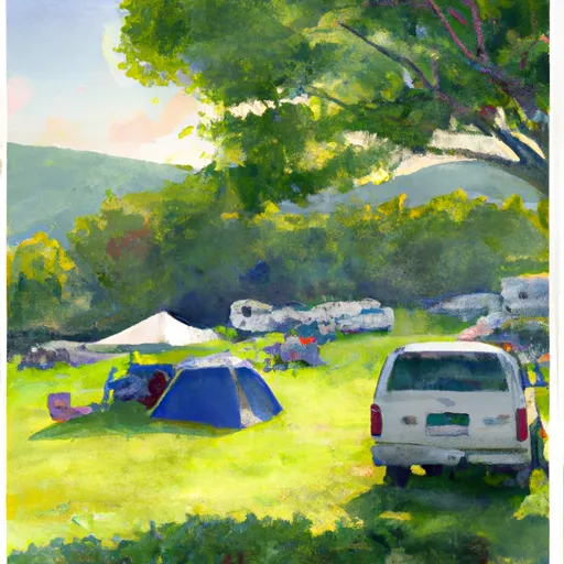
The campground offers a range of amenities, including water and electric hookups, toilets, showers, and a dump station. While reservations are recommended, the campground operates on a first-come, first-served basis. There are 23 campsites available, each with a picnic table and fire ring.
An interesting fact about the Underhill area is that it is home to the highest peak in Vermont, Mount Mansfield, which can be seen from many of the campsites. The best time to visit the campground is during the summer months, from June to August, when temperatures are warm and the weather is conducive to outdoor activities. Average temperatures during this time range from the mid-70s during the day to the low 50s at night.
Overall, Underhill Campground is a fantastic option for campers seeking a peaceful and scenic retreat in the heart of Vermont's mountains.
What's on-site at Underhill Campsite
Key facilities Snoflo tracks for this campground. Confirm with the operator before booking -- amenities can change seasonally.
Plan your trip down to the hour
Same weather feed Snoflo's iOS app uses -- updated continuously from NOAA / yr.no.
Next 5 days, hour by hour
Temperature line with weather symbols on top, snow + rain accumulation as columns, humidity as a dotted line.
5-day forecast table
Every 3 hours, broken out across temperature, snow, rain, humidity, and wind. Each cell is colour-coded relative to the column min/max so trends jump out at a glance.
| Time | Condition | Temp (°F) | Snow (in) | Rain (in) | Humidity (%) | Wind (mps) | Wind dir |
|---|---|---|---|---|---|---|---|
| Loading detailed forecast… | |||||||
15-day temperature & precipitation
Daily temperatures, snow, and rain projected over the next two weeks. Hover any point for the full breakdown.
Other campgrounds in the area
Snoflo-tracked campsites within driving distance of Underhill Campsite, with reservations status.
| Campground | Reservations | Toilets | View |
|---|---|---|---|
| Bugbee Landing Campsite | ✗ | ✗ | → |
| Pastures Campground | ✗ | ✗ | → |
| Hexacuba Shelter | ✓ | ✗ | → |
| Ore Hill Tentsite | ✗ | ✗ | → |
| Harkdale Farm Campsite | ✗ | ✗ | → |
Nearby streamflow
USGS streamgauges within reach of Underhill Campsite -- pulled live from the National Water Information System.
| Streamgauge | Discharge | View |
|---|---|---|
| Wells River At Wells River | 44 cfs | → |
| Connecticut River At Wells River | 1,470 cfs | → |
| Ompompanoosuc River At Union Village | 16 cfs | → |
| East Orange Branch At East Orange | 6 cfs | → |
| Baker River Near Rumney | 45 cfs | → |
| Pemigewasset River At Woodstock | 141 cfs | → |
Nearby snow depths
NRCS SNOTEL stations within reach of Underhill Campsite -- relevant when planning a shoulder-season or alpine trip.
| SNOTEL station | Snowpack | 24h Snowfall | View |
|---|---|---|---|
| Corinth | 0.0 in | 0.0 in | → |
| Mascoma River | 0.0 in | 0.0 in | → |
| West Topsham 2sw | 0.0 in | 0.0 in | → |
| Strafford 2.4 Sse | 0.0 in | 0.0 in | → |
| Ryegate 1.5 N | 0.0 in | 0.0 in | → |
| Nohrsc Hubbard Brook | 0.0 in | 0.0 in | → |
Plan a longer trip
The closest parks, lakes, boat launches, and paddle runs so a camping night can grow into a full weekend.
Parks
- Hulbert Outdoor Center
- Bedell Bridge State Historic Park
- Podunk Wildlife Management Area
- Thetford Hill State Forest
- Union Village Dam
- Kibling Wildlife Management Area
Boat launches
- Bugbee Landing
- Indian Pond Boat Launch
- Lake Morey
- Connecticut River
- Bedell Bridge
- Upper Baker Pond Boat Launch
Points of interest
- State Route 25
- Old Creamery Road
- Samuel Morey Memorial Bridge
- Bedell Bridge
- South Newbury Village Historic District
- West Newbury Village Historic District
Paddle runs
- Woodstock/Thornton Town Line To Thornton Railroad Bridge
- Thornton Railroad Bridge To Bridgewater/Bristol Town Line
- Headwaters At Profile Lake To Southern Boundary Of Franconia Notch State Park
- Source Above Fr 55 To Proclamation Boundary (Stony Brook)
- Headwaters To Folsom Brook
- Headwaters To Woodstock, Vt
Camping essentials & Leave No Trace
- Pack it in, pack it out
- Take all trash, food scraps, and gear back with you to keep campsites clean and protect wildlife.
- Respect wildlife
- Observe animals from a distance, store food securely, and never feed wildlife to maintain natural behavior and safety.
- Know before you go
- Check weather, fire restrictions, trail conditions, and permit requirements to ensure a safe and well-planned trip.
- Minimize campfire impact
- Use established fire rings, keep fires small, fully extinguish them, or opt for a camp stove when fires are restricted.
- Leave what you find
- Preserve natural and cultural features by avoiding removal of plants, rocks, artifacts, or other elements of the environment.
Set push alerts in the Snoflo app
Save Underhill Campsite as a favorite, set a custom threshold (precipitation, snowpack, freezing temperatures), and the iOS app will push the moment conditions cross.
About Underhill Campsite
Can I make reservations at Underhill Campsite?
This campground does not appear to accept reservations -- it's typically first-come, first-served. Arrive early on summer weekends.
How fresh is the weather data on this page?
The hourly forecast updates throughout the day from the NOAA / yr.no public feeds. Streamflow data is pulled live from USGS streamgauges and snowpack from the NRCS SNOTEL network.
What's the best time of year to visit?
Use the 15-day temperature & precipitation outlook on this page to plan -- pick a window with comfortable temperatures and low precipitation. For longer trips, the 5-day hourly meteogram shows snow + rain accumulation hour-by-hour.
How do I get to Underhill Campsite?
Tap Directions in the hero above to open driving directions in Google Maps, or Open in map to center the Snoflo interactive map on the campground.
Can I get alerts when conditions change?
Yes -- alerts are managed through the Snoflo iOS app. Favorite this campground, set a threshold (temperature, snowpack, precipitation), and you'll get a push the moment it crosses.
Other campgrounds near here
Snoflo-tracked campgrounds within driving distance of Underhill Campsite.