Bean Creek Basin Backcountry Camping Campground
Community Reviews
Been here? Share the conditions.
Reviews, ratings & photos are added in the free Snoflo iOS app — rate a spot, tag the conditions, and your visit is verified by location. Add or manage your reviews from the app.
Bean Creek Basin Backcountry Camping
Reservations are not accepted at Bean Creek Basin Backcountry Camping. Campsites are available on a first-come, first-served basis, so it is advisable to arrive early to secure a spot, especially during peak seasons. The best time of year to visit this camping area is during the summer months when the weather is pleasant and the area is easily accessible. However, it is important to check weather conditions and trail conditions before heading out, as the area can experience heavy snowfall and difficult terrain during the winter months.
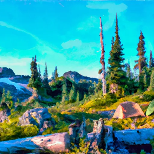
While camping in Bean Creek Basin, there are a few notable points of interest to explore. The area offers stunning views of the surrounding mountains and valleys, making it a paradise for hiking and photography enthusiasts. However, it is crucial to be cautious of wildlife, such as bears and mountain lions, and adhere to proper bear safety protocols. Additionally, the area is prone to avalanches, so campers should be aware of the potential risks and take necessary precautions. Overall, Bean Creek Basin Backcountry Camping provides a remote and pristine camping experience for outdoor enthusiasts seeking solitude and natural beauty.
What's on-site at Bean Creek Basin Backcountry Camping
Key facilities Snoflo tracks for this campground. Confirm with the operator before booking -- amenities can change seasonally.
Plan your trip down to the hour
Same weather feed Snoflo's iOS app uses -- updated continuously from NOAA / yr.no.
Next 5 days, hour by hour
Temperature line with weather symbols on top, snow + rain accumulation as columns, humidity as a dotted line.
5-day forecast table
Every 3 hours, broken out across temperature, snow, rain, humidity, and wind. Each cell is colour-coded relative to the column min/max so trends jump out at a glance.
| Time | Condition | Temp (°F) | Snow (in) | Rain (in) | Humidity (%) | Wind (mps) | Wind dir |
|---|---|---|---|---|---|---|---|
| Loading detailed forecast… | |||||||
15-day temperature & precipitation
Daily temperatures, snow, and rain projected over the next two weeks. Hover any point for the full breakdown.
Other campgrounds in the area
Snoflo-tracked campsites within driving distance of Bean Creek Basin Backcountry Camping, with reservations status.
| Campground | Reservations | Toilets | View |
|---|---|---|---|
| Beverly Campground | ✓ | ✗ | → |
| Beverly | ✗ | ✓ | → |
| North Fork Teanaway River Dispersed Camping | ✗ | ✗ | → |
| Teanaway Guard Station | ✓ | ✗ | → |
| De Roux Campground | ✗ | ✗ | → |
Nearby streamflow
USGS streamgauges within reach of Bean Creek Basin Backcountry Camping -- pulled live from the National Water Information System.
| Streamgauge | Discharge | View |
|---|---|---|
| Icicle Creek Above Snow Creek Near Leavenworth | 209 cfs | → |
| Wenatchee River At Peshastin | 1,030 cfs | → |
| Wenatchee River At Monitor | 1,050 cfs | → |
| Wenatchee River At Plain | 824 cfs | → |
| Chiwawa River Near Plain | 227 cfs | → |
| Mad River At Ardenvoir | 24 cfs | → |
Nearby snow depths
NRCS SNOTEL stations within reach of Bean Creek Basin Backcountry Camping -- relevant when planning a shoulder-season or alpine trip.
| SNOTEL station | Snowpack | 24h Snowfall | View |
|---|---|---|---|
| Sasse Ridge | 0.0 in | 0.0 in | → |
| Nohrsc Blewett Pass | 0.0 in | 0.0 in | → |
| Blewett Pass | 0.0 in | 0.0 in | → |
| Nohrsc Sasse Ridge | 0.0 in | 0.0 in | → |
| Nohrsc Fish Lake | 0.0 in | 0.0 in | → |
| Fish Lake | 22.0 in | 0.0 in | → |
Plan a longer trip
The closest parks, lakes, boat launches, and paddle runs so a camping night can grow into a full weekend.
Parks
- Lion's Club Park
- Peshastin Pinnacles State Park
- John Simpson Memorial Park
- Lake Easton State Park
- Natatorium Park
- Cashmere Riverside Park
Boat launches
- Scatter Creek Campground
- Salmon La Sac Road, Ronald
- Wish Poosh Campground And Picnic Area
- Icicle Creek
- Lake Cabins Road Kittitas County
- Cooper Lake Boat Launch
Points of interest
- Hex Mountain Trailhead
- Kbhr Set
- Carpenter Museum
- Telephone Museum
- Greater Leveanworth Museum
- Nutcracker Museum & Store
Paddle runs
- Headwaters In Se1/4 Of Sec 29, T24n, R13e To Confluence With Cle Elum River
- Alpine Lakes Wilderness Boundary To City Of Leavenworth Water Intake In Se1/4 Of Sec 28, T24n, R17e
- Alpine Lakes Wilderness Boundary To Private Land Boundary At North Section Line Of Sec 3, T23n, R14e
- Private Land Boundary To Head Of Lake Cle Elum Reservoir
- Rock Island Campground To Ida Creek
- Headwaters In Nw1/4 Of Sec 12, T24n, R13e To Alpine Lakes Wilderness Boundary
Camping essentials & Leave No Trace
- Pack it in, pack it out
- Take all trash, food scraps, and gear back with you to keep campsites clean and protect wildlife.
- Respect wildlife
- Observe animals from a distance, store food securely, and never feed wildlife to maintain natural behavior and safety.
- Know before you go
- Check weather, fire restrictions, trail conditions, and permit requirements to ensure a safe and well-planned trip.
- Minimize campfire impact
- Use established fire rings, keep fires small, fully extinguish them, or opt for a camp stove when fires are restricted.
- Leave what you find
- Preserve natural and cultural features by avoiding removal of plants, rocks, artifacts, or other elements of the environment.
Set push alerts in the Snoflo app
Save Bean Creek Basin Backcountry Camping as a favorite, set a custom threshold (precipitation, snowpack, freezing temperatures), and the iOS app will push the moment conditions cross.
About Bean Creek Basin Backcountry Camping
Can I make reservations at Bean Creek Basin Backcountry Camping?
This campground does not appear to accept reservations -- it's typically first-come, first-served. Arrive early on summer weekends.
How fresh is the weather data on this page?
The hourly forecast updates throughout the day from the NOAA / yr.no public feeds. Streamflow data is pulled live from USGS streamgauges and snowpack from the NRCS SNOTEL network.
What's the best time of year to visit?
Use the 15-day temperature & precipitation outlook on this page to plan -- pick a window with comfortable temperatures and low precipitation. For longer trips, the 5-day hourly meteogram shows snow + rain accumulation hour-by-hour.
How do I get to Bean Creek Basin Backcountry Camping?
Tap Directions in the hero above to open driving directions in Google Maps, or Open in map to center the Snoflo interactive map on the campground.
Can I get alerts when conditions change?
Yes -- alerts are managed through the Snoflo iOS app. Favorite this campground, set a threshold (temperature, snowpack, precipitation), and you'll get a push the moment it crosses.
Other campgrounds near here
Snoflo-tracked campgrounds within driving distance of Bean Creek Basin Backcountry Camping.