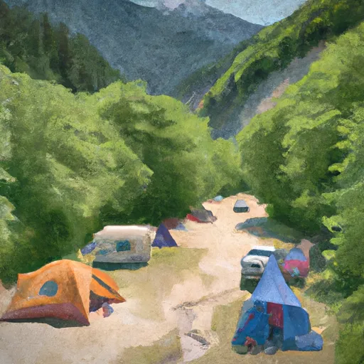
Campground: Iron Creek campground
Community Reviews
Been here? Share the conditions.
Reviews, ratings & photos are added in the free Snoflo iOS app — rate a spot, tag the conditions, and your visit is verified by location. Add or manage your reviews from the app.
Campground: Iron Creek
Reservations are accepted at Iron Creek campground, making it easier for campers to secure a spot during peak season. However, it is advisable to book in advance, especially if you plan to visit during weekends or holidays when the campground tends to be busier.
The best time to visit Iron Creek camping area is during the summer months, from June to September, when the weather is pleasant, and outdoor activities are in full swing. This is also the ideal time to explore the nearby hiking trails and enjoy the natural beauty surrounding the campground.
While camping at Iron Creek, campers should be cautious of wildlife encounters, specifically bears. It is important to properly store food and dispose of trash in bear-resistant containers to minimize the risk of attracting them to the campground. Additionally, campers are advised to follow all fire safety guidelines and be mindful of potential fire hazards due to the dry climate. By adhering to these precautions, visitors can have a safe and enjoyable camping experience at Iron Creek campground.
What's on-site at Campground: Iron Creek
Key facilities Snoflo tracks for this campground. Confirm with the operator before booking -- amenities can change seasonally.
Plan your trip down to the hour
Same weather feed Snoflo's iOS app uses -- updated continuously from NOAA / yr.no.
Next 5 days, hour by hour
Temperature line with weather symbols on top, snow + rain accumulation as columns, humidity as a dotted line.
5-day forecast table
Every 3 hours, broken out across temperature, snow, rain, humidity, and wind. Each cell is colour-coded relative to the column min/max so trends jump out at a glance.
| Time | Condition | Temp (°F) | Snow (in) | Rain (in) | Humidity (%) | Wind (mps) | Wind dir |
|---|---|---|---|---|---|---|---|
| Loading detailed forecast… | |||||||
15-day temperature & precipitation
Daily temperatures, snow, and rain projected over the next two weeks. Hover any point for the full breakdown.
Other campgrounds in the area
Snoflo-tracked campsites within driving distance of Campground: Iron Creek, with reservations status.
| Campground | Reservations | Toilets | View |
|---|---|---|---|
| Iron Creek Campground | ✗ | ✗ | → |
| Campground: Tower Rock | ✓ | ✗ | → |
| Obscurity Camp | ✗ | ✗ | → |
| Taidnapam Park - Tacoma Power | ✓ | ✓ | → |
| Panhandle Camp | ✗ | ✗ | → |
Nearby streamflow
USGS streamgauges within reach of Campground: Iron Creek -- pulled live from the National Water Information System.
| Streamgauge | Discharge | View |
|---|---|---|
| Cowlitz River Near Kosmos | 2,250 cfs | → |
| Cispus River Ab Yellowjacket Creek Near Randle | 410 cfs | → |
| Cowlitz River At Randle | 1,120 cfs | → |
| Cowlitz River At Packwood | 943 cfs | → |
| Nisqually River Near National | 439 cfs | → |
| Mineral Creek Near Mineral | 42 cfs | → |
Nearby snow depths
NRCS SNOTEL stations within reach of Campground: Iron Creek -- relevant when planning a shoulder-season or alpine trip.
| SNOTEL station | Snowpack | 24h Snowfall | View |
|---|---|---|---|
| Pinto Rock | 0.0 in | 0.0 in | → |
| Nohrsc Pinto Rock | 0.0 in | 0.0 in | → |
| Lone Pine | 1.0 in | 0.0 in | → |
| Nohrsc Lone Pine | 1.0 in | 0.0 in | → |
| Spirit Lake Tunnel Outlet On S Coldwater Crk | 0.0 in | 0.0 in | → |
| Spirit Lake | 0.0 in | 0.0 in | → |
Plan a longer trip
The closest parks, lakes, boat launches, and paddle runs so a camping night can grow into a full weekend.
Parks
- Wilderness Tatoosh
- Wilderness Glacier View
- Wilderness Goat Rocks
- Mount Rainier National Park
- Snoqualmie National Forest
- Ike Kinswa State Park
Boat launches
- Peters Road Lewis County
- Lewis County
- Champion Haul Road Lewis County
- Kosmos Road West Lewis County
- Spirit Lake Highway Cowlitz County
Points of interest
- Site: Woods Creek Watchable Wildlife Area Tr. #247
- Forest Road 25
- Harmony Falls Viewpoint
- Smith Creek Viewpoint
- Loowit Viewpoint
- Bcj Gallery
Paddle runs
- Goat Rocks Wilderness Bounday To Cowlitz Falls Ferc Project Boundary In Ne1/4 Of Nw1/4 Of Sec 4, T11n, R6e
- Nw1/4 Of Sec 21, T11n, R8e To Confluence With Cispus River
- Headwaters In Se1/4 Of Sec 31, T10n, R6e To Mount St. Helens National Volcanic Monument Boundary
- Road 2809 Bridge Crossing In Sw1/4 Of Sec 8, T10n, R8e To Nw1/4 Of Sec 21, T11n, R8e
- Mount St. Helens National Volcanic Monument Boundary To To Point River Reenters Mshnvm In Se 1/4 Of Sec 11, T10n, R5e
- Mount St. Helens National Volcanic Monument Boundary To Mount St. Helens National Volcanic Boundary In Sw 1/4 Of Sec 32, T11n, R5e
Camping essentials & Leave No Trace
- Pack it in, pack it out
- Take all trash, food scraps, and gear back with you to keep campsites clean and protect wildlife.
- Respect wildlife
- Observe animals from a distance, store food securely, and never feed wildlife to maintain natural behavior and safety.
- Know before you go
- Check weather, fire restrictions, trail conditions, and permit requirements to ensure a safe and well-planned trip.
- Minimize campfire impact
- Use established fire rings, keep fires small, fully extinguish them, or opt for a camp stove when fires are restricted.
- Leave what you find
- Preserve natural and cultural features by avoiding removal of plants, rocks, artifacts, or other elements of the environment.
Set push alerts in the Snoflo app
Save Campground: Iron Creek as a favorite, set a custom threshold (precipitation, snowpack, freezing temperatures), and the iOS app will push the moment conditions cross.
About Campground: Iron Creek
Can I make reservations at Campground: Iron Creek?
Yes -- this campground accepts reservations. Snoflo recommends booking early for peak season; check the operator (Recreation.gov / state park system / private operator) for the booking window and cancellation policy.
How fresh is the weather data on this page?
The hourly forecast updates throughout the day from the NOAA / yr.no public feeds. Streamflow data is pulled live from USGS streamgauges and snowpack from the NRCS SNOTEL network.
What's the best time of year to visit?
Use the 15-day temperature & precipitation outlook on this page to plan -- pick a window with comfortable temperatures and low precipitation. For longer trips, the 5-day hourly meteogram shows snow + rain accumulation hour-by-hour.
How do I get to Campground: Iron Creek?
Tap Directions in the hero above to open driving directions in Google Maps, or Open in map to center the Snoflo interactive map on the campground.
Can I get alerts when conditions change?
Yes -- alerts are managed through the Snoflo iOS app. Favorite this campground, set a threshold (temperature, snowpack, precipitation), and you'll get a push the moment it crosses.
Other campgrounds near here
Snoflo-tracked campgrounds within driving distance of Campground: Iron Creek.