Hart's Pass Campground campground
Community Reviews
Been here? Share the conditions.
Reviews, ratings & photos are added in the free Snoflo iOS app — rate a spot, tag the conditions, and your visit is verified by location. Add or manage your reviews from the app.
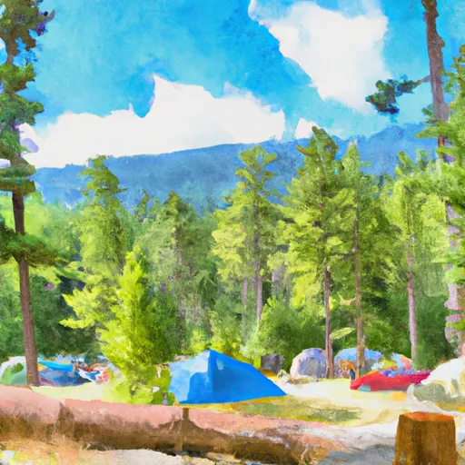
Hart's Pass Campground
Reservations are not accepted at Hart's Pass Campground, and campsites are available on a first-come, first-served basis. This makes it the perfect destination for spontaneous adventurers or those seeking a peaceful getaway without the need for advanced planning. It is worth noting that due to its remote location and limited campsites, the campground tends to fill up quickly during busy weekends, so arriving early is recommended.
The best time to visit Hart's Pass Campground is during the summer months, from June to September, when the weather is milder and the campground is accessible. However, be prepared for cooler temperatures at this high elevation campground. Situated at an elevation of around 6,000 feet, Hart's Pass offers breathtaking views of the surrounding mountains and meadows. Keep in mind that this remote area lacks cell phone reception, so it is essential to plan accordingly and inform loved ones of your itinerary. Additionally, wildlife, including bears and mountain goats, are present in the area, so it is important to properly store food and avoid approaching or feeding any wild animals.
What's on-site at Hart's Pass Campground
Key facilities Snoflo tracks for this campground. Confirm with the operator before booking -- amenities can change seasonally.
Plan your trip down to the hour
Same weather feed Snoflo's iOS app uses -- updated continuously from NOAA / yr.no.
Next 5 days, hour by hour
Temperature line with weather symbols on top, snow + rain accumulation as columns, humidity as a dotted line.
5-day forecast table
Every 3 hours, broken out across temperature, snow, rain, humidity, and wind. Each cell is colour-coded relative to the column min/max so trends jump out at a glance.
| Time | Condition | Temp (°F) | Snow (in) | Rain (in) | Humidity (%) | Wind (mps) | Wind dir |
|---|---|---|---|---|---|---|---|
| Loading detailed forecast… | |||||||
15-day temperature & precipitation
Daily temperatures, snow, and rain projected over the next two weeks. Hover any point for the full breakdown.
Other campgrounds in the area
Snoflo-tracked campsites within driving distance of Hart's Pass Campground, with reservations status.
| Campground | Reservations | Toilets | View |
|---|---|---|---|
| Harts Pass | ✗ | ✓ | → |
| Meadows Campground | ✗ | ✗ | → |
| River Bend | ✗ | ✓ | → |
| Ballard | ✗ | ✓ | → |
Nearby streamflow
USGS streamgauges within reach of Hart's Pass Campground -- pulled live from the National Water Information System.
| Streamgauge | Discharge | View |
|---|---|---|
| Methow River Above Goat Creek Near Mazama | 258 cfs | → |
| Thunder Creek Near Newhalem | 721 cfs | → |
| Andrews Creek Near Mazama | 10 cfs | → |
| Newhalem Creek Near Newhalem | 30 cfs | → |
| Skagit River At Newhalem | 3,710 cfs | → |
| Stehekin River At Stehekin | 1,100 cfs | → |
Nearby snow depths
NRCS SNOTEL stations within reach of Hart's Pass Campground -- relevant when planning a shoulder-season or alpine trip.
| SNOTEL station | Snowpack | 24h Snowfall | View |
|---|---|---|---|
| Nohrsc Harts Pass | 0.0 in | 0.0 in | → |
| Harts Pass | 0.0 in | 0.0 in | → |
| Swamp Creek | 0.0 in | 0.0 in | → |
| Nohrsc Swamp Creek | 0.0 in | 0.0 in | → |
| Rainy Pass | 0.0 in | 0.0 in | → |
| Rainy Pass | 0.0 in | 0.0 in | → |
Plan a longer trip
The closest parks, lakes, boat launches, and paddle runs so a camping night can grow into a full weekend.
Parks
- Wilderness Pasayten
- North Cascades National Park
- Pearrygin Lake State Park
- Wilderness Stephen Mather
- Lake Chelan National Recreation Area
- Ross Lake National Recreation Area
Points of interest
- Public Swimming Hole
- Washington Pass Observation Site
- Pasayten Airstrip Guard Station
- Sulphide–Frisco Cabin
- Rock Cabin
- Pasayten Cabin
Paddle runs
- Confluence With Rampart Creek To Pasayten Wilderness Boundary
- Confluence With Brush Creek To Private Land Boundary Near Lost River In Nw1/4 Of Sec 5, T36n, R19e
- Pasayten Wilderness Boundary To Confluence With Methow River
- Pasayten Wilderness Boundary To Point On Range Line Between Sec 12, R14e And Sec 17, R16e
- Point On Range Line To Ruby Creek
- Swamp Creek To Ruby Creek
Camping essentials & Leave No Trace
- Pack it in, pack it out
- Take all trash, food scraps, and gear back with you to keep campsites clean and protect wildlife.
- Respect wildlife
- Observe animals from a distance, store food securely, and never feed wildlife to maintain natural behavior and safety.
- Know before you go
- Check weather, fire restrictions, trail conditions, and permit requirements to ensure a safe and well-planned trip.
- Minimize campfire impact
- Use established fire rings, keep fires small, fully extinguish them, or opt for a camp stove when fires are restricted.
- Leave what you find
- Preserve natural and cultural features by avoiding removal of plants, rocks, artifacts, or other elements of the environment.
Set push alerts in the Snoflo app
Save Hart's Pass Campground as a favorite, set a custom threshold (precipitation, snowpack, freezing temperatures), and the iOS app will push the moment conditions cross.
About Hart's Pass Campground
Can I make reservations at Hart's Pass Campground?
Yes -- this campground accepts reservations. Snoflo recommends booking early for peak season; check the operator (Recreation.gov / state park system / private operator) for the booking window and cancellation policy.
How fresh is the weather data on this page?
The hourly forecast updates throughout the day from the NOAA / yr.no public feeds. Streamflow data is pulled live from USGS streamgauges and snowpack from the NRCS SNOTEL network.
What's the best time of year to visit?
Use the 15-day temperature & precipitation outlook on this page to plan -- pick a window with comfortable temperatures and low precipitation. For longer trips, the 5-day hourly meteogram shows snow + rain accumulation hour-by-hour.
How do I get to Hart's Pass Campground?
Tap Directions in the hero above to open driving directions in Google Maps, or Open in map to center the Snoflo interactive map on the campground.
Can I get alerts when conditions change?
Yes -- alerts are managed through the Snoflo iOS app. Favorite this campground, set a threshold (temperature, snowpack, precipitation), and you'll get a push the moment it crosses.
Other campgrounds near here
Snoflo-tracked campgrounds within driving distance of Hart's Pass Campground.