Robert W. Craig - Jennings Randolph Lake campground
Community Reviews
Been here? Share the conditions.
Reviews, ratings & photos are added in the free Snoflo iOS app — rate a spot, tag the conditions, and your visit is verified by location. Add or manage your reviews from the app.
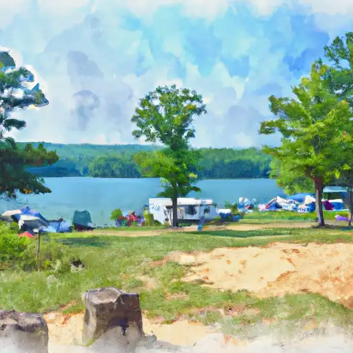
Robert W. Craig - Jennings Randolph Lake
Reservations are accepted at the Robert W. Craig - Jennings Randolph Lake camping area, allowing campers to secure their preferred spot in advance. It is advisable to make a reservation, especially during peak seasons, to guarantee availability.
The best time of year to visit this camping area is during the spring and fall seasons when the weather is pleasant, and the foliage showcases its vibrant colors. Campers can enjoy scenic hikes, fishing, boating, and wildlife observation during these times. However, it is important to note that the campground can become crowded during holiday weekends and summer months, so planning ahead is recommended.
While exploring the camping area, campers should be cautious of ticks and other insects, as well as poison ivy. It is advisable to bring bug repellent and wear appropriate clothing to protect against these potential hazards. Additionally, being mindful of personal belongings and keeping a clean campsite can help prevent encounters with wildlife. Overall, the Robert W. Craig - Jennings Randolph Lake camping area provides a serene and well-equipped environment for an enjoyable camping experience.
What's on-site at Robert W. Craig - Jennings Randolph Lake
Key facilities Snoflo tracks for this campground. Confirm with the operator before booking -- amenities can change seasonally.
Plan your trip down to the hour
Same weather feed Snoflo's iOS app uses -- updated continuously from NOAA / yr.no.
Next 5 days, hour by hour
Temperature line with weather symbols on top, snow + rain accumulation as columns, humidity as a dotted line.
5-day forecast table
Every 3 hours, broken out across temperature, snow, rain, humidity, and wind. Each cell is colour-coded relative to the column min/max so trends jump out at a glance.
| Time | Condition | Temp (°F) | Snow (in) | Rain (in) | Humidity (%) | Wind (mps) | Wind dir |
|---|---|---|---|---|---|---|---|
| Loading detailed forecast… | |||||||
15-day temperature & precipitation
Daily temperatures, snow, and rain projected over the next two weeks. Hover any point for the full breakdown.
Other campgrounds in the area
Snoflo-tracked campsites within driving distance of Robert W. Craig - Jennings Randolph Lake, with reservations status.
| Campground | Reservations | Toilets | View |
|---|---|---|---|
| Robert W. Craig Memorial Campground | ✗ | ✗ | → |
| Big Run State Park | ✓ | ✗ | → |
| Lost Land Run - Potomac State Forest | ✗ | ✗ | → |
| Abram’S Creek Retreat & Campground | ✗ | ✗ | → |
| Wallman/Laurel Run - Potomac State Forest | ✗ | ✗ | → |
Nearby streamflow
USGS streamgauges within reach of Robert W. Craig - Jennings Randolph Lake -- pulled live from the National Water Information System.
| Streamgauge | Discharge | View |
|---|---|---|
| North Branch Potomac River At Barnum | 305 cfs | → |
| Savage Riv Bl Savage Riv Dam Near Bloomington | 63 cfs | → |
| North Branch Potomac River At Luke | 372 cfs | → |
| Crabtree Creek Near Swanton | 154 cfs | → |
| North Branch Potomac River At Kitzmiller | 103 cfs | → |
| Georges Creek At Franklin | 19 cfs | → |
Nearby snow depths
NRCS SNOTEL stations within reach of Robert W. Craig - Jennings Randolph Lake -- relevant when planning a shoulder-season or alpine trip.
| SNOTEL station | Snowpack | 24h Snowfall | View |
|---|---|---|---|
| Savage Dam | 0.0 in | 0.0 in | → |
| Keyser 2 Ssw Coop | 0.0 in | 0.0 in | → |
| Mc Henry 4.8 Sse | 0.0 in | 0.0 in | → |
| Sines Deep Creek Lake | 0.0 in | 0.0 in | → |
| Grantsville 2.0 Ese | 0.0 in | 0.0 in | → |
| Bayard Coop | 0.0 in | 0.0 in | → |
Plan a longer trip
The closest parks, lakes, boat launches, and paddle runs so a camping night can grow into a full weekend.
Parks
- Savage River State Forest
- Big Run State Park
- Deep Creek Lake State Park
- Dans Mountain State Park
- New Germany State Park
- Potomac State Forest
Boat launches
- Mount Zion Road Garrett County
- Howell Run
- Deep Creek Lake State Park
- Blue Trail Garrett County
- Mount Storm Lake
- Stoney River (Mt. Storm Lake)
Fishing spots
- Savage River Reservoir
- Little Youghiogheny River Reservoir
- Georges Creek
- Dans Mountain Pond
- Broadford Lake
- Deep Creek Lake
Points of interest
- Bloomington Viaduct
- Eroded Outcropping
- Waverly Street Bridge
- Anderson Chapel
- Lonaconing Historic District
- Lonaconing Furnace
Paddle runs
- Begins As River Passes Under The Herrington Manor Road Bridge At Oakland, Maryland To The Corporate Boundary Of Friendsville, Maryland
- Begins Below The Youghiogheny River Lake Dam In Confluence, Pennsylvania To Ends In South Connellsville, Pennsylvania
- State Park Bridge To North Fork
- Perennial Stream At Forks To Dolly Sods Wilderness Boundary
- Jake Hill Road Bridge To Shreve Store
- High Ridge Run To Outskirts Of Hopeville
Camping essentials & Leave No Trace
- Pack it in, pack it out
- Take all trash, food scraps, and gear back with you to keep campsites clean and protect wildlife.
- Respect wildlife
- Observe animals from a distance, store food securely, and never feed wildlife to maintain natural behavior and safety.
- Know before you go
- Check weather, fire restrictions, trail conditions, and permit requirements to ensure a safe and well-planned trip.
- Minimize campfire impact
- Use established fire rings, keep fires small, fully extinguish them, or opt for a camp stove when fires are restricted.
- Leave what you find
- Preserve natural and cultural features by avoiding removal of plants, rocks, artifacts, or other elements of the environment.
Set push alerts in the Snoflo app
Save Robert W. Craig - Jennings Randolph Lake as a favorite, set a custom threshold (precipitation, snowpack, freezing temperatures), and the iOS app will push the moment conditions cross.
About Robert W. Craig - Jennings Randolph Lake
Can I make reservations at Robert W. Craig - Jennings Randolph Lake?
Yes -- this campground accepts reservations. Snoflo recommends booking early for peak season; check the operator (Recreation.gov / state park system / private operator) for the booking window and cancellation policy.
How fresh is the weather data on this page?
The hourly forecast updates throughout the day from the NOAA / yr.no public feeds. Streamflow data is pulled live from USGS streamgauges and snowpack from the NRCS SNOTEL network.
What's the best time of year to visit?
Use the 15-day temperature & precipitation outlook on this page to plan -- pick a window with comfortable temperatures and low precipitation. For longer trips, the 5-day hourly meteogram shows snow + rain accumulation hour-by-hour.
How do I get to Robert W. Craig - Jennings Randolph Lake?
Tap Directions in the hero above to open driving directions in Google Maps, or Open in map to center the Snoflo interactive map on the campground.
Can I get alerts when conditions change?
Yes -- alerts are managed through the Snoflo iOS app. Favorite this campground, set a threshold (temperature, snowpack, precipitation), and you'll get a push the moment it crosses.
Other campgrounds near here
Snoflo-tracked campgrounds within driving distance of Robert W. Craig - Jennings Randolph Lake.