Trail Point Campground
Community Reviews
Been here? Share the conditions.
Reviews, ratings & photos are added in the free Snoflo iOS app — rate a spot, tag the conditions, and your visit is verified by location. Add or manage your reviews from the app.
Trail Point
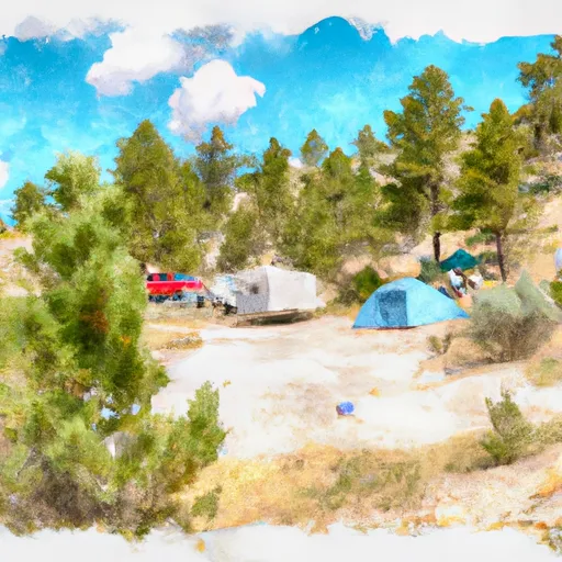
Trail Point Camping Area offers 21 campsites, each with a picnic table and fire ring. The campground also provides vault toilets and potable water. The sites are available on a first-come, first-served basis, so visitors should arrive early to secure a spot.
An interesting fact about the area is that it was once used as a ranger station and housed a horse corral. The corral has since been removed, but visitors can still see remnants of the old ranger station.
The best time to visit Trail Point Camping Area is during the summer months when the average temperature is around 70°F during the day, and cooler in the evenings. However, visitors should be prepared for sudden weather changes, as the altitude can cause quick temperature drops and thunderstorms. Overall, Trail Point Camping Area offers a serene and peaceful camping experience with stunning views and easy access to nearby attractions.
What's on-site at Trail Point
Key facilities Snoflo tracks for this campground. Confirm with the operator before booking -- amenities can change seasonally.
Plan your trip down to the hour
Same weather feed Snoflo's iOS app uses -- updated continuously from NOAA / yr.no.
Next 5 days, hour by hour
Temperature line with weather symbols on top, snow + rain accumulation as columns, humidity as a dotted line.
5-day forecast table
Every 3 hours, broken out across temperature, snow, rain, humidity, and wind. Each cell is colour-coded relative to the column min/max so trends jump out at a glance.
| Time | Condition | Temp (°F) | Snow (in) | Rain (in) | Humidity (%) | Wind (mps) | Wind dir |
|---|---|---|---|---|---|---|---|
| Loading detailed forecast… | |||||||
15-day temperature & precipitation
Daily temperatures, snow, and rain projected over the next two weeks. Hover any point for the full breakdown.
Other campgrounds in the area
Snoflo-tracked campsites within driving distance of Trail Point, with reservations status.
| Campground | Reservations | Toilets | View |
|---|---|---|---|
| 6a3 | ✗ | ✗ | → |
| Trail Bay | ✓ | ✗ | → |
| Se Arm Inlet | ✓ | ✗ | → |
| Terrace Point | ✓ | ✗ | → |
| 5e2 | ✗ | ✗ | → |
Nearby streamflow
USGS streamgauges within reach of Trail Point -- pulled live from the National Water Information System.
| Streamgauge | Discharge | View |
|---|---|---|
| Yellowstone River At Yellowstone Lk Outlet Ynp | 2,470 cfs | → |
| Snake River Ab Jackson Lake At Flagg Ranch Wy | 409 cfs | → |
| Buffalo Fork Ab Lava Creek Nr Moran Wy | 619 cfs | → |
| South Fork Shoshone River Near Valley | 187 cfs | → |
| Pacific Creek At Moran Wy | 81 cfs | → |
| Snake River Nr Moran Wy | 4,910 cfs | → |
Nearby snow depths
NRCS SNOTEL stations within reach of Trail Point -- relevant when planning a shoulder-season or alpine trip.
| SNOTEL station | Snowpack | 24h Snowfall | View |
|---|---|---|---|
| Two Ocean Plateau | 0.0 in | 0.0 in | → |
| Nohrsc Two Ocean Plateau Snotel | 0.0 in | 0.0 in | → |
| Sylvan Road | 0.0 in | 0.0 in | → |
| Nohrsc Sylvan Lake Snotel | 0.0 in | 0.0 in | → |
| Sylvan Lake | 0.0 in | 0.0 in | → |
| Nohrsc Sylvan Road Snotel | 0.0 in | 0.0 in | → |
Plan a longer trip
The closest parks, lakes, boat launches, and paddle runs so a camping night can grow into a full weekend.
Points of interest
- Eagle Pass
- Grant Village Visitor Center
- Parting Of The Waters National Natural Landmark
- Thumb Paintpots
- West Thumb Geyser Basin
- Natural Bridge
Paddle runs
- Southeastern Boundary Of The Park To Yellowstone Lake Inlet
- Confluence Of North/South Forks To Yellowstone Np Boundary
- Thorofare Creek Source To Yellowstone Np Boundary
- Open Creek Source To Confluence With Thorofare
- Outlet Of Yellowstone Lake At Fishing Bridge To Lower Falls
- The Headwaters To The Southern Yellowstone National Park Boundary
Camping essentials & Leave No Trace
- Pack it in, pack it out
- Take all trash, food scraps, and gear back with you to keep campsites clean and protect wildlife.
- Respect wildlife
- Observe animals from a distance, store food securely, and never feed wildlife to maintain natural behavior and safety.
- Know before you go
- Check weather, fire restrictions, trail conditions, and permit requirements to ensure a safe and well-planned trip.
- Minimize campfire impact
- Use established fire rings, keep fires small, fully extinguish them, or opt for a camp stove when fires are restricted.
- Leave what you find
- Preserve natural and cultural features by avoiding removal of plants, rocks, artifacts, or other elements of the environment.
Set push alerts in the Snoflo app
Save Trail Point as a favorite, set a custom threshold (precipitation, snowpack, freezing temperatures), and the iOS app will push the moment conditions cross.
About Trail Point
Can I make reservations at Trail Point?
Yes -- this campground accepts reservations. Snoflo recommends booking early for peak season; check the operator (Recreation.gov / state park system / private operator) for the booking window and cancellation policy.
How fresh is the weather data on this page?
The hourly forecast updates throughout the day from the NOAA / yr.no public feeds. Streamflow data is pulled live from USGS streamgauges and snowpack from the NRCS SNOTEL network.
What's the best time of year to visit?
Use the 15-day temperature & precipitation outlook on this page to plan -- pick a window with comfortable temperatures and low precipitation. For longer trips, the 5-day hourly meteogram shows snow + rain accumulation hour-by-hour.
How do I get to Trail Point?
Tap Directions in the hero above to open driving directions in Google Maps, or Open in map to center the Snoflo interactive map on the campground.
Can I get alerts when conditions change?
Yes -- alerts are managed through the Snoflo iOS app. Favorite this campground, set a threshold (temperature, snowpack, precipitation), and you'll get a push the moment it crosses.
Other campgrounds near here
Snoflo-tracked campgrounds within driving distance of Trail Point.