-
Snoflo Premium
Get unlimited access to all our content
With no Ad interruptions! - Start Your Free Trial Login with existing account
Irvington
Eden Index
Climate
9.6
•
Recreation
3.1
•
Community
0.9
•
Safeguard
5.2/10
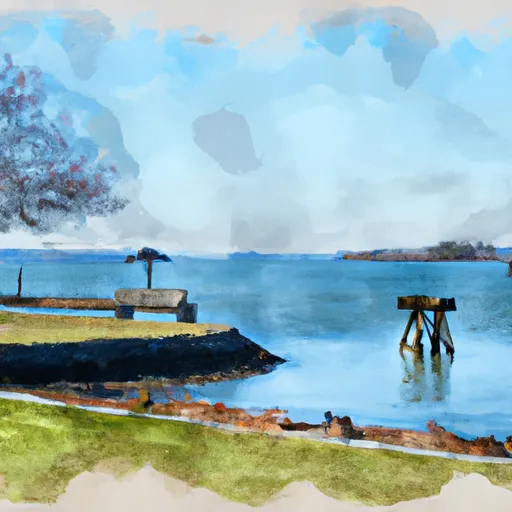
Irvington, Virginia is a charming town located on Virginia's Northern Neck peninsula, known for its picturesque landscapes and inviting atmosphere. The climate in Irvington is characterized by mild winters and warm summers, making it a pleasant destination all year round. The town enjoys a diverse hydrology environment, with the Rappahannock River to the north and the Chesapeake Bay to the east. These water bodies offer various outdoor recreational activities such as boating, fishing, kayaking, and paddleboarding.
Irvington's hydrology constituents also include numerous creeks and marshes, providing opportunities for wildlife observation and birdwatching. The region is rich in biodiversity, with an abundance of flora and fauna to explore. In addition to its hydrological features, Irvington boasts beautiful parks and nature trails that offer scenic views and a chance to connect with nature.
The town's outdoor recreation opportunities extend beyond water-based activities. Hiking and biking enthusiasts can explore the nearby trails, immersing themselves in the natural beauty of the area. The Irvington Commons and the Hughlett Point Natural Area Preserve are prime examples of the outdoor recreational spaces available for residents and visitors alike. In conclusion, with its favorable climate, diverse hydrology constituents, and ample outdoor recreation opportunities, Irvington, Virginia is a haven for nature lovers and outdoor enthusiasts.
What is the Eden Index?
The Snoflo Eden Index serves as a comprehensive rating system for regions, evaluating their desirability through a holistic assessment of climate health, outdoor recreation opportunities, and natural disaster risk, acknowledging the profound impact of these factors on livability and well-being.
Climate Health Indicator (CHI): 9.6
Irvington receives approximately
1208mm of rain per year,
with humidity levels near 76%
and air temperatures averaging around
15°C.
Irvington has a plant hardyness factor of
7, meaning
plants and agriculture in this region tend to thrive during the non-winter months.
By considering the ideal temperature range, reliable water supplies, clean air, and stable seasonal rain or snowpacks, the Climate Health Indicator (CHI) underscores the significance of a healthy climate as the foundation for quality living.
A healthy climate is paramount for ensuring a high quality of life and livability in a region, fostering both physical well-being and environmental harmony. This can be characterized by ideal temperatures, reliable access to water supplies, clean air, and consistent seasonal rain or snowpacks.
Weather Forecast
Streamflow Conditions
Lower Chesapeake
Area Rivers
Lower Chesapeake
Snowpack Depths
Lower Chesapeake
Reservoir Storage Capacity
Lower Chesapeake
Groundwater Levels
Recreational Opportunity Index (ROI): 3.1
The Recreational Opportunity Index (ROI) recognizes the value of outdoor recreational options, such as parks, hiking trails, camping sites, and fishing spots, while acknowledging that climate plays a pivotal role in ensuring the comfort and consistency of these experiences.
Access to outdoor recreational opportunities, encompassing activities such as parks, hiking, camping, and fishing, is crucial for overall well-being, and the climate plays a pivotal role in enabling and enhancing these experiences, ensuring that individuals can engage in nature-based activities comfortably and consistently.
Camping Areas
Campground | Campsites | Reservations | Toilets | Showers | Elevation |
---|---|---|---|---|---|
Belle Isle State Park | None | 12 ft | |||
Kings Creek - Cheatham Annex Military | None | 24 ft | |||
Newport News City Park | None | 96 ft | |||
Gosnolds Hope Park | None | 6 ft | |||
Fort Eustis Military | None | 30 ft | |||
Point Lookout State Park | 143 | 2 ft | |||
Bethel Military | None | 27 ft | |||
The Colonies Military | None | 5 ft |
Catastrophe Safeguard Index (CSI):
The Catastrophe Safeguard Index (CSI) recognizes that natural disaster risk, encompassing floods, fires, hurricanes, and tornadoes, can drastically affect safety and the overall appeal of an area.
The level of natural disaster risk in a region significantly affects safety and the overall livability, with climate change amplifying these risks by potentially increasing the frequency and intensity of events like floods, fires, hurricanes, and tornadoes, thereby posing substantial challenges to community resilience and well-being.
Community Resilience Indicator (CRI): 0.9
The Community Resilience Indicator (CRI) recognizes that education, healthcare, and socioeconomics are crucial to the well-being of a region. The CRI acknowledges the profound impact of these elements on residents' overall quality of life. By evaluating educational resources, healthcare accessibility, and economic inclusivity, the index captures the essential aspects that contribute to a thriving community, fostering resident satisfaction, equity, and social cohesion.