Keokee

Climate Recreation Community Catastrophe

Keokee
Eden Index

Climate 7.5 Recreation 4.5 Community Safeguard

4.6/10

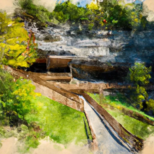
Keokee, Virginia is a small town located in the southwestern part of the state. The climate in Keokee is characterized by mild to cool winters and warm summers. The average annual precipitation is around 40 inches, with rainfall evenly distributed throughout the year. Snowfall is common during the winter months.

The town is nestled in the heart of the Appalachian Mountains, providing a picturesque landscape with abundant natural resources. The area is known for its diverse hydrology constituents, including numerous creeks, rivers, and springs. These water bodies offer excellent opportunities for fishing, canoeing, and kayaking. The region is also home to several hiking trails, allowing outdoor enthusiasts to explore the scenic beauty of the surrounding mountains.

Keokee is a perfect destination for nature lovers, offering outdoor recreation opportunities like camping, birdwatching, and wildlife observation. The nearby Jefferson National Forest provides ample opportunities for hunting and hiking. The town's proximity to natural attractions like Cumberland Gap National Historical Park and Breaks Interstate Park further enhances the outdoor experience. Keokee, Virginia is a hidden gem for those seeking a tranquil environment amidst nature's beauty.

What is the Eden Index?

The Snoflo Eden Index serves as a comprehensive rating system for regions, evaluating their desirability through a holistic assessment of climate health, outdoor recreation opportunities, and natural disaster risk, acknowledging the profound impact of these factors on livability and well-being.


Climate Health Indicator (CHI): 7.5


Keokee receives approximately 1469mm of rain per year, with humidity levels near 81% and air temperatures averaging around 12°C. Keokee has a plant hardyness factor of 6, meaning plants and agriculture in this region thrive during a short period during spring and early summer. Most plants will die off during the colder winter months. By considering the ideal temperature range, reliable water supplies, clean air, and stable seasonal rain or snowpacks, the Climate Health Indicator (CHI) underscores the significance of a healthy climate as the foundation for quality living.

A healthy climate is paramount for ensuring a high quality of life and livability in a region, fostering both physical well-being and environmental harmony. This can be characterized by ideal temperatures, reliable access to water supplies, clean air, and consistent seasonal rain or snowpacks.


Weather Forecast


Streamflow Conditions

Upper Tennessee

Area Rivers

Upper Tennessee


Snowpack Depths

Upper Tennessee


Reservoir Storage Capacity

Upper Tennessee


Groundwater Levels


Recreational Opportunity Index (ROI): 4.5


The Recreational Opportunity Index (ROI) recognizes the value of outdoor recreational options, such as parks, hiking trails, camping sites, and fishing spots, while acknowledging that climate plays a pivotal role in ensuring the comfort and consistency of these experiences. Access to outdoor recreational opportunities, encompassing activities such as parks, hiking, camping, and fishing, is crucial for overall well-being, and the climate plays a pivotal role in enabling and enhancing these experiences, ensuring that individuals can engage in nature-based activities comfortably and consistently.


Camping Areas

Campground Campsites Reservations Toilets Showers Elevation
Rocky Bluff 30 1,753 ft
Jenny Wiley State Park 115 857 ft
Natural Tunnel State Park None 1,703 ft
Paintsville Lake State Park 40 618 ft
Mount Pisgah - Blue Ridge Parkway None 4,859 ft
Cataloochee - Great Smoky Mountains 27 2,652 ft
Kinser Park None 1,314 ft
Sunburst 10 3,230 ft
Houston Valley None 1,843 ft
Paint Creek 21 1,750 ft
Carr Creek State Park 40 1,093 ft
Portal 31 RV Park 20 1,841 ft
Littcarr - Carr Creek Lake None 1,050 ft
Davidson River 160 2,166 ft
Big Creek - Great Smoky Mountains 12 1,701 ft

Catastrophe Safeguard Index (CSI):


The Catastrophe Safeguard Index (CSI) recognizes that natural disaster risk, encompassing floods, fires, hurricanes, and tornadoes, can drastically affect safety and the overall appeal of an area. The level of natural disaster risk in a region significantly affects safety and the overall livability, with climate change amplifying these risks by potentially increasing the frequency and intensity of events like floods, fires, hurricanes, and tornadoes, thereby posing substantial challenges to community resilience and well-being.


Community Resilience Indicator (CRI):


The Community Resilience Indicator (CRI) recognizes that education, healthcare, and socioeconomics are crucial to the well-being of a region. The CRI acknowledges the profound impact of these elements on residents' overall quality of life. By evaluating educational resources, healthcare accessibility, and economic inclusivity, the index captures the essential aspects that contribute to a thriving community, fostering resident satisfaction, equity, and social cohesion.


Log Your Visit

When was your last visit to ?

Add a Photo

How was it? How were conditions?

Rate the


Submit

Leave A Review


Submit

Upload an Image


Favorite Limit Reached