-
Snoflo Premium
Get unlimited access to all our content
With no Ad interruptions! - Start Your Free Trial Login with existing account
Shenandoah-Caver
Eden Index
Climate
9.7
•
Recreation
2.0
•
Community
2.7
•
Safeguard
5.3/10
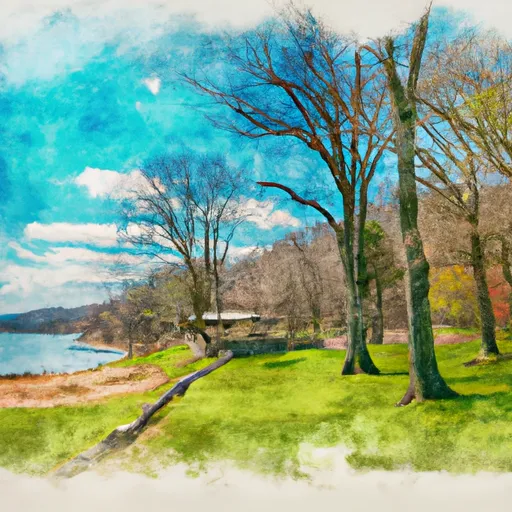
Shenandoah-Caver, Virginia is a picturesque region located in the Shenandoah Valley, known for its stunning natural beauty and abundant outdoor recreation opportunities. The climate in Shenandoah-Caver is generally mild, with warm summers and cool winters. Annual precipitation is evenly spread throughout the year, providing lush greenery and flourishing ecosystems.
The area is characterized by its unique hydrology constituents, which include numerous caves and underground water systems. Shenandoah-Caver is home to the famous Shenandoah Caverns, a natural wonder featuring stunning formations and crystal clear underground streams. The underground water systems play a vital role in maintaining the region's ecological balance.
Outdoor enthusiasts will find a plethora of recreational activities to enjoy in Shenandoah-Caver. Hiking and camping are popular pursuits, with numerous trails offering breathtaking views of the surrounding mountains and valleys. The Shenandoah River is a great spot for fishing, kayaking, and canoeing. The region also boasts excellent opportunities for birdwatching, wildlife observation, and photography.
Overall, Shenandoah-Caver, Virginia presents a perfect blend of natural beauty, diverse hydrology constituents, and exciting outdoor recreation opportunities for nature enthusiasts and adventure seekers alike.
What is the Eden Index?
The Snoflo Eden Index serves as a comprehensive rating system for regions, evaluating their desirability through a holistic assessment of climate health, outdoor recreation opportunities, and natural disaster risk, acknowledging the profound impact of these factors on livability and well-being.
Climate Health Indicator (CHI): 9.7
Shenandoah-Caver receives approximately
930mm of rain per year,
with humidity levels near 78%
and air temperatures averaging around
12°C.
Shenandoah-Caver has a plant hardyness factor of
6, meaning
plants and agriculture in this region thrive during a short period during spring and early summer. Most
plants will die off during the colder winter months.
By considering the ideal temperature range, reliable water supplies, clean air, and stable seasonal rain or snowpacks, the Climate Health Indicator (CHI) underscores the significance of a healthy climate as the foundation for quality living.
A healthy climate is paramount for ensuring a high quality of life and livability in a region, fostering both physical well-being and environmental harmony. This can be characterized by ideal temperatures, reliable access to water supplies, clean air, and consistent seasonal rain or snowpacks.
Weather Forecast
Streamflow Conditions
Potomac
Area Rivers
Potomac
Snowpack Depths
Potomac
Reservoir Storage Capacity
Potomac
Groundwater Levels
Recreational Opportunity Index (ROI): 2.0
The Recreational Opportunity Index (ROI) recognizes the value of outdoor recreational options, such as parks, hiking trails, camping sites, and fishing spots, while acknowledging that climate plays a pivotal role in ensuring the comfort and consistency of these experiences.
Access to outdoor recreational opportunities, encompassing activities such as parks, hiking, camping, and fishing, is crucial for overall well-being, and the climate plays a pivotal role in enabling and enhancing these experiences, ensuring that individuals can engage in nature-based activities comfortably and consistently.
Camping Areas
Campground | Campsites | Reservations | Toilets | Showers | Elevation |
---|---|---|---|---|---|
Rocky Gap State Park | 278 | 1,231 ft | |||
Loft Mountain - Shenandoah National Park | None | 3,369 ft | |||
Hawk | 15 | 1,381 ft | |||
Trout Pond | 70 | 1,995 ft | |||
Wolf Gap | 10 | 2,245 ft | |||
Short Mountain WMA | 74 | 2,136 ft | |||
Spring Gap - C and O Canal National Park | 19 | 563 ft | |||
Camp Roosevelt | 10 | 1,325 ft | |||
James River State Park | None | 592 ft |
Nearby Ski Areas
Catastrophe Safeguard Index (CSI):
The Catastrophe Safeguard Index (CSI) recognizes that natural disaster risk, encompassing floods, fires, hurricanes, and tornadoes, can drastically affect safety and the overall appeal of an area.
The level of natural disaster risk in a region significantly affects safety and the overall livability, with climate change amplifying these risks by potentially increasing the frequency and intensity of events like floods, fires, hurricanes, and tornadoes, thereby posing substantial challenges to community resilience and well-being.
Community Resilience Indicator (CRI): 2.7
The Community Resilience Indicator (CRI) recognizes that education, healthcare, and socioeconomics are crucial to the well-being of a region. The CRI acknowledges the profound impact of these elements on residents' overall quality of life. By evaluating educational resources, healthcare accessibility, and economic inclusivity, the index captures the essential aspects that contribute to a thriving community, fostering resident satisfaction, equity, and social cohesion.