West Clear Creek fishing
As of July 15, 2026, the nearest streamgauge to West Clear Creek — Verde River Near Camp Verde — reports 34 cfs. Source: USGS gauge data, refreshed throughout the day.
Community Reviews
Been here? Share the conditions.
Reviews, ratings & photos are added in the free Snoflo iOS app — rate a spot, tag the conditions, and your visit is verified by location. Add or manage your reviews from the app.
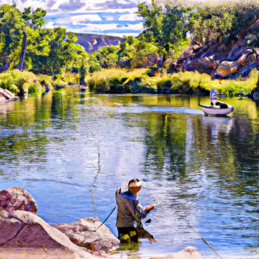
West Clear Creek
What's biting at West Clear Creek
Species commonly reported here -- tap any card for techniques, target seasons, and other waters where it's been caught.
Plan your trip down to the hour
Same weather feed Snoflo's iOS app uses -- updated continuously from NOAA / yr.no.
Next 5 days, hour by hour
Temperature line with weather symbols on top, snow + rain accumulation as columns, humidity as a dotted line.
5-day forecast table
Every 3 hours, broken out across temperature, snow, rain, humidity, and wind. Each cell is colour-coded relative to the column min/max so trends jump out at a glance.
| Time | Condition | Temp (°F) | Snow (in) | Rain (in) | Humidity (%) | Wind (mps) | Wind dir |
|---|---|---|---|---|---|---|---|
| Loading detailed forecast… | |||||||
15-day temperature & precipitation
Daily temperatures, snow, and rain projected over the next two weeks. Hover any point for the full breakdown.
Nearby streamflow
USGS streamgauges within reach of West Clear Creek -- updated continuously from the National Water Information System.
| Streamgauge | Discharge | View |
|---|---|---|
| Verde River Near Camp Verde | 34 cfs | → |
| West Clear Creek Near Camp Verde | 17 cfs | → |
| Wet Beaver Creek Near Rimrock | 8 cfs | → |
| Dry Beaver Creek Near Rimrock | · | → |
| Oak Creek Near Cornville | 22 cfs | → |
| Agua Fria River Near Mayer | 1 cfs | → |
Plan a longer trip
The closest campgrounds, parks, boat launches, and reservoirs so a fishing run can grow into a weekend.
Campgrounds
- Clear Creek Rv Park
- Clear Creek And Clear Creek Group Campgrounds
- Clear Creek National Forest Campground
- Distant Drums Rv Resort
- Bull Pen Dispersed Campground
- Lawrence Crossing Dispersed Camping Area
Parks
- Verde River Access Area
- Csm Martin R. Barreras Gunny Park
- Fort Verde State Historic Park
- Montezuma Castle National Monument
- Sycamore Community Park
- Montezuma Well
Reservoirs
- Camp Verde Wwtp Duck Ponds
- Sedona Effluent Reservoirs
- Phoenix Cement Dam #1
- Foxboro Lake Dam
- Mesa Reservoir
- Lynx Creek
Boat launches
- Clear Creek Fishing Site
- Beasley Flat Picnic Site
- White Bridge Picnic Site And Boat Launch
- East Lagoon Loop Trail Cottonwood
- Pheasant Road Cottonwood
- Stoneman Lake
Points of interest
- Bull Pen Day Use Area
- Life Line
- Trail To Montezuma Castle
- Layers Of Time
- The Neighborhood
- Windows In The Past
Paddle runs
- Prescott National Forest Boundary To North Edge Of Private Land In Sec 33, T17n, R3e, Near Clarkdale
- White Bridge To Beasley Flat
- Clear Creek Wilderness Boundary To Dispersed Camping Area At Clear Creek Campground
- Wet Beaver Creek Wilderness Boundary To Private Land In Sec 32, T15n, R6e
- Sycamore Creek
- Little Ash Creek
Angling safety & ethics
- Know the regulations
- Check local fishing rules, seasons, size limits, and license requirements to ensure legal and sustainable angling.
- Handle fish responsibly
- Use wet hands, minimize air exposure, and release fish gently to improve survival rates when practicing catch-and-release.
- Choose the right gear
- Match your rod, line, and tackle to the species and conditions to increase success and reduce unnecessary harm to fish.
- Respect the waterway
- Avoid disturbing habitat, prevent bank erosion, and keep a safe distance from spawning areas to protect ecosystems.
- Keep it clean
- Pack out all line, hooks, bait containers, and trash. Discarded gear can injure wildlife and degrade waterways.
Set push alerts in the Snoflo app
Save West Clear Creek as a favorite, set a custom threshold (water temperature, streamflow, snowpack), and the iOS app will push the moment conditions cross.
About West Clear Creek
What fish species are found at West Clear Creek?
Snoflo tracks the species commonly reported at West Clear Creek -- see the Fish Species panel above for the live list with images and links to per-species pages.
How fresh is the weather data on this page?
The hourly forecast updates throughout the day from the NOAA / yr.no public feeds. Streamflow data comes live from USGS streamgauges, also refreshed continuously.
Can I get alerts when conditions change?
Yes -- alerts are managed through the Snoflo iOS app. Favorite this area, set a threshold (water temperature, streamflow, snowpack), and you'll get a push the moment it crosses.
Do I need a fishing license?
Yes. Check your state agency's regulations for license requirements, seasons, size limits, and any waterbody-specific rules before fishing West Clear Creek.
How do I get to West Clear Creek?
Tap Open in map in the hero above to center the Snoflo interactive map on this area, or grab the coordinates from the location facts panel.
Other angling spots near here
Snoflo-tracked fishing areas within driving distance of West Clear Creek.