Green River River Run
Community Reviews
Been here? Share the conditions.
Reviews, ratings & photos are added in the free Snoflo iOS app — rate a spot, tag the conditions, and your visit is verified by location. Add or manage your reviews from the app.
Green River
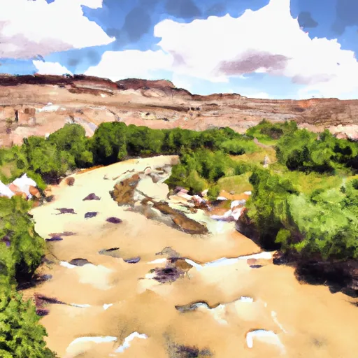
The Green River in Utah is a popular whitewater river run located in the western United States. The ideal streamflow range for the Green River is between 1,000 and 3,000 cubic feet per second (cfs). The class rating for this river ranges from Class II to Class V, depending on the segment of the river being run. The river has a total length of approximately 730 miles, but the most popular whitewater segment is the 44-mile stretch from Green River, Utah, to Mineral Bottom.
The specific rapids and obstacles on the Green River vary depending on the segment being run. Some notable rapids on the popular 44-mile stretch include Little Niagara, Hells Half Mile, and Sock-it-to-Me. The river also features stunning scenery, including towering red rock formations and winding canyons.
Regulations for the Green River vary depending on the specific segment being run. However, all river users are required to obtain a permit from the National Park Service. Additionally, all river users must follow Leave No Trace principles and pack out all trash and waste.
Overall, the Green River in Utah is a scenic and challenging whitewater river run that attracts adventurers from around the world. It is important to research and follow specific regulations for the area to ensure a safe and enjoyable experience.
Plan your run down to the hour
Same weather feed Snoflo's iOS app uses -- updated continuously from NOAA / yr.no. Watch the precipitation column on the meteogram; rain ahead of a run typically lifts flows 12-48 hours later depending on the basin.
Next 5 days, hour by hour
Temperature line with weather symbols on top, snow + rain accumulation as columns, humidity as a dotted line.
5-day forecast table
Every 3 hours, broken out across temperature, snow, rain, humidity, and wind. Each cell is colour-coded relative to the column min/max.
| Time | Condition | Temp (°F) | Snow (in) | Rain (in) | Humidity (%) | Wind (mps) | Wind dir |
|---|---|---|---|---|---|---|---|
| Loading detailed forecast… | |||||||
15-day temperature & precipitation
Daily temperatures, snow, and rain projected over the next two weeks -- the upstream story that drives next week's flows.
Regional streamflow levels
USGS streamgauges around Green River -- useful for spotting upstream pulses and gauging which tributary is contributing what.
| Streamgauge | Discharge | View |
|---|---|---|
| Green River At Green River | 1,880 cfs | → |
| San Rafael River Near Green River | 4 cfs | → |
| San Rafael River At Mouth Near Green River | 13 cfs | → |
| Price River At Woodside | 7 cfs | → |
| Green River At Mineral Bottom Nr Cynlnds Ntl Park | 1,740 cfs | → |
| Desert Seep Wash Near Wellington | 2 cfs | → |
Plan a longer trip
The closest boat launches, other paddle runs, and campgrounds so a day on the water can grow into a full weekend.
Boat launches
- South Green River Boulevard 450, Green River
- Crystal Geyser Road Grand County
- Swasey Rapid Boat Ramp Site
- Hastings Road Grand County
- Nefertiti Rapid Recreation Site
- Price River Put In
Campgrounds
- Green River State Park
- Love's
- Swasey's Beach Campground
- Swasey Rapid Recreation Site
- Overlook Campsite
- Stone Cabin Recreation Site
Points of interest
Whitewater safety
- Check the flow before you run
- Use the linked-gauge card and Regional Flow panel above. Class ratings change with flow -- a Class III at low water can become Class IV+ at high water.
- Know your skill ceiling
- Pick runs comfortably below your ceiling. Cold-water and big-water runs raise the consequences of any mistake.
- Wear the right gear
- Helmet, PFD, drysuit / wetsuit when water is below 60°F. Throw bag, knife, and whistle on your person, not in the boat.
- Scout, set safety, and run with a team
- Scout new rapids on foot, set safety with throw bags above the consequence pool, and run with at least one other competent paddler.
- Respect the river
- Strainers, undercuts, low-head dams, and wood can kill at any class rating. When in doubt, portage.
Set push alerts in the Snoflo app
Save Green River as a favorite, set a discharge threshold (e.g. "alert me when flow hits 600 cfs"), and the iOS app pushes the moment the linked gauge crosses.
About Green River
What's the optimal flow for Green River?
The optimal flow depends on the section and the craft. Check the Run Details panel for the linked gauge and current status.
How fresh is the cfs reading on this page?
The linked USGS streamgauge reports continuously (every 15 minutes); Snoflo refreshes throughout the day. Hover the streamflow sparkline to read individual datapoints.
What's the whitewater class?
See the Run Details panel for the class rating Snoflo tracks for this run. Class ratings change with flow -- a Class III at low water can become Class IV in high water.
Where do I put in / take out?
Tap Directions in the hero above to open driving directions to the put-in. For shuttle planning, check the Nearby Boat Launches panel and the river run operator's site.
Can I get alerts when flows hit the optimal range?
Yes -- alerts are managed in the Snoflo iOS app. Favorite this run, set a discharge threshold, and you'll get a push the moment the gauge crosses.
Other runs near here
Snoflo-tracked paddle runs within driving distance of Green River.