Arnett Creek - Forest Road #4 To Middle Of Sec 7,T2s, R12e River Run
Community Reviews
Been here? Share the conditions.
Reviews, ratings & photos are added in the free Snoflo iOS app — rate a spot, tag the conditions, and your visit is verified by location. Add or manage your reviews from the app.
Arnett Creek - Forest Road #4 To Middle Of Sec 7,T2s, R12e
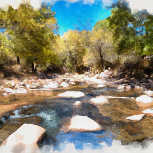
There are several notable river rapids and obstacles along the way. At the beginning of the run, there is a Class III rapid known as "The Ledges." Later on, there is a Class III+ rapid called "Vulture Eye." The run also has a few smaller rapids and wave trains, making it an enjoyable experience for intermediate paddlers.
It is important to note that the Arnett Creek run has specific regulations to protect the environment and wildlife. The area is designated as a Wilderness Area, so visitors must follow Leave No Trace principles. Additionally, motorized vehicles are not allowed within the area.
Overall, the Arnett Creek - Forest Road #4 to Middle of Sec 7, T2S, R12E run is a beautiful and exciting whitewater experience for intermediate paddlers. It is important to check the streamflow before heading out and to follow all regulations to protect the environment.
Plan your run down to the hour
Same weather feed Snoflo's iOS app uses -- updated continuously from NOAA / yr.no. Watch the precipitation column on the meteogram; rain ahead of a run typically lifts flows 12-48 hours later depending on the basin.
Next 5 days, hour by hour
Temperature line with weather symbols on top, snow + rain accumulation as columns, humidity as a dotted line.
5-day forecast table
Every 3 hours, broken out across temperature, snow, rain, humidity, and wind. Each cell is colour-coded relative to the column min/max.
| Time | Condition | Temp (°F) | Snow (in) | Rain (in) | Humidity (%) | Wind (mps) | Wind dir |
|---|---|---|---|---|---|---|---|
| Loading detailed forecast… | |||||||
15-day temperature & precipitation
Daily temperatures, snow, and rain projected over the next two weeks -- the upstream story that drives next week's flows.
Regional streamflow levels
USGS streamgauges around Arnett Creek - Forest Road #4 To Middle Of Sec 7,T2s, R12e -- useful for spotting upstream pulses and gauging which tributary is contributing what.
| Streamgauge | Discharge | View |
|---|---|---|
| Queen Creek Below Whitlow Dam Nr Superior | 1 cfs | → |
| Pinto Cr Blw Haunted Canyon Nr Miami | 98 cfs | → |
| Gila River At Kelvin | 33 cfs | → |
| Florence-Casa Grande Canal | · | → |
| Pinto Creek Near Miami | 149 cfs | → |
| Pinal Creek At Inspiration Dam | 2 cfs | → |
Plan a longer trip
The closest boat launches, other paddle runs, and campgrounds so a day on the water can grow into a full weekend.
Other river runs
- Telegraph Creek - Forest Road #4 To Confluence With Arnett Creek
- Kelvin Run
- Pinto Creek
- Gila River (Middle)
- Southwest Boundary Of Salt River Canyon Wilderness To State Highway 288 Bridge
Campgrounds
- Barnett Camp
- Oak Flat
- Gold Canyon Dispersed Camping
- Sulphide Del Rey Campground
- Sulphide Del Ray
- Sulphide Del Rey
Fishing spots
Whitewater safety
- Check the flow before you run
- Use the linked-gauge card and Regional Flow panel above. Class ratings change with flow -- a Class III at low water can become Class IV+ at high water.
- Know your skill ceiling
- Pick runs comfortably below your ceiling. Cold-water and big-water runs raise the consequences of any mistake.
- Wear the right gear
- Helmet, PFD, drysuit / wetsuit when water is below 60°F. Throw bag, knife, and whistle on your person, not in the boat.
- Scout, set safety, and run with a team
- Scout new rapids on foot, set safety with throw bags above the consequence pool, and run with at least one other competent paddler.
- Respect the river
- Strainers, undercuts, low-head dams, and wood can kill at any class rating. When in doubt, portage.
Set push alerts in the Snoflo app
Save Arnett Creek - Forest Road #4 To Middle Of Sec 7,T2s, R12e as a favorite, set a discharge threshold (e.g. "alert me when flow hits 600 cfs"), and the iOS app pushes the moment the linked gauge crosses.
About Arnett Creek - Forest Road #4 To Middle Of Sec 7,T2s, R12e
What's the optimal flow for Arnett Creek - Forest Road #4 To Middle Of Sec 7,T2s, R12e?
The optimal flow depends on the section and the craft. Check the Run Details panel for the linked gauge and current status.
How fresh is the cfs reading on this page?
The linked USGS streamgauge reports continuously (every 15 minutes); Snoflo refreshes throughout the day. Hover the streamflow sparkline to read individual datapoints.
What's the whitewater class?
See the Run Details panel for the class rating Snoflo tracks for this run. Class ratings change with flow -- a Class III at low water can become Class IV in high water.
Where do I put in / take out?
Tap Directions in the hero above to open driving directions to the put-in. For shuttle planning, check the Nearby Boat Launches panel and the river run operator's site.
Can I get alerts when flows hit the optimal range?
Yes -- alerts are managed in the Snoflo iOS app. Favorite this run, set a discharge threshold, and you'll get a push the moment the gauge crosses.
Other runs near here
Snoflo-tracked paddle runs within driving distance of Arnett Creek - Forest Road #4 To Middle Of Sec 7,T2s, R12e.