Red Creek To Southern Border Of Mazatzal Wilderness River Run
Community Reviews
Been here? Share the conditions.
Reviews, ratings & photos are added in the free Snoflo iOS app — rate a spot, tag the conditions, and your visit is verified by location. Add or manage your reviews from the app.
Red Creek To Southern Border Of Mazatzal Wilderness
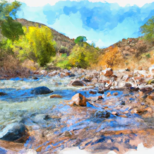
There are several notable rapids and obstacles on the river, including "The Notch," "Highway to Hell," and "Washout." These rapids provide an exciting challenge for experienced paddlers. However, caution should always be exercised as the river also contains several submerged rocks and other hazards.
Specific regulations apply to the area, and all paddlers must obtain a permit before embarking on the river trip. Additionally, all garbage and waste must be packed out, and campfires are prohibited within 1/4 mile of the river. Overall, the Red Creek to Southern Border of Mazatzal Wilderness is an exhilarating river run that promises adventure and breathtaking views of the Arizona wilderness.
Plan your run down to the hour
Same weather feed Snoflo's iOS app uses -- updated continuously from NOAA / yr.no. Watch the precipitation column on the meteogram; rain ahead of a run typically lifts flows 12-48 hours later depending on the basin.
Next 5 days, hour by hour
Temperature line with weather symbols on top, snow + rain accumulation as columns, humidity as a dotted line.
5-day forecast table
Every 3 hours, broken out across temperature, snow, rain, humidity, and wind. Each cell is colour-coded relative to the column min/max.
| Time | Condition | Temp (°F) | Snow (in) | Rain (in) | Humidity (%) | Wind (mps) | Wind dir |
|---|---|---|---|---|---|---|---|
| Loading detailed forecast… | |||||||
15-day temperature & precipitation
Daily temperatures, snow, and rain projected over the next two weeks -- the upstream story that drives next week's flows.
Regional streamflow levels
USGS streamgauges around Red Creek To Southern Border Of Mazatzal Wilderness -- useful for spotting upstream pulses and gauging which tributary is contributing what.
| Streamgauge | Discharge | View |
|---|---|---|
| Verde R Blw Tangle Creek | 373 cfs | → |
| Wet Bottom Creek Near Childs | 39 cfs | → |
| East Verde River Near Childs | 1 cfs | → |
| Verde River Blw Bartlett Dam | 161 cfs | → |
| Cave Creek Blw Cottonwood Cr Near Cave Creek | · | → |
| New River Near Rock Springs | 0 cfs | → |
Plan a longer trip
The closest boat launches, other paddle runs, and campgrounds so a day on the water can grow into a full weekend.
Boat launches
- Horseshoe Reservoir
- North Bartlett Dam Road Maricopa County
- Bartlett Reservoir
- Boat Launch Road [Fsr 185] Maricopa County
Other river runs
- Southern Border Of Mazatzal Wilderness To Sheep Creek Bridge
- West Boundary Of L.F. Ranch To Verde Wild And Scenic River
- Bishop Creek
- Larry Creek
- Silver Creek
Campgrounds
- Sheeps Bridge
- Sheep Bridge Dispersed Camping
- Ocotillo Rec And Boating Site Dispersed
- Catfish Point Dispersed Camping Area
- Horseshoe Dispersed Camping
Fishing spots
- Deadman Creek
- South Fork Deadman Creek
- Bartlett Reservoir
- North Canyon Creek
- West Clear Creek
- Horsethief Boating Site / Day Use Area
Whitewater safety
- Check the flow before you run
- Use the linked-gauge card and Regional Flow panel above. Class ratings change with flow -- a Class III at low water can become Class IV+ at high water.
- Know your skill ceiling
- Pick runs comfortably below your ceiling. Cold-water and big-water runs raise the consequences of any mistake.
- Wear the right gear
- Helmet, PFD, drysuit / wetsuit when water is below 60°F. Throw bag, knife, and whistle on your person, not in the boat.
- Scout, set safety, and run with a team
- Scout new rapids on foot, set safety with throw bags above the consequence pool, and run with at least one other competent paddler.
- Respect the river
- Strainers, undercuts, low-head dams, and wood can kill at any class rating. When in doubt, portage.
Set push alerts in the Snoflo app
Save Red Creek To Southern Border Of Mazatzal Wilderness as a favorite, set a discharge threshold (e.g. "alert me when flow hits 600 cfs"), and the iOS app pushes the moment the linked gauge crosses.
About Red Creek To Southern Border Of Mazatzal Wilderness
What's the optimal flow for Red Creek To Southern Border Of Mazatzal Wilderness?
The optimal flow depends on the section and the craft. Check the Run Details panel for the linked gauge and current status.
How fresh is the cfs reading on this page?
The linked USGS streamgauge reports continuously (every 15 minutes); Snoflo refreshes throughout the day. Hover the streamflow sparkline to read individual datapoints.
What's the whitewater class?
See the Run Details panel for the class rating Snoflo tracks for this run. Class ratings change with flow -- a Class III at low water can become Class IV in high water.
Where do I put in / take out?
Tap Directions in the hero above to open driving directions to the put-in. For shuttle planning, check the Nearby Boat Launches panel and the river run operator's site.
Can I get alerts when flows hit the optimal range?
Yes -- alerts are managed in the Snoflo iOS app. Favorite this run, set a discharge threshold, and you'll get a push the moment the gauge crosses.
Other runs near here
Snoflo-tracked paddle runs within driving distance of Red Creek To Southern Border Of Mazatzal Wilderness.