Begins 1 Mile Below The Redwall In Both Of The Main Arms To Confluence With The Colorado River river run
Begins 1 Mile Below The Redwall In Both Of The Main Arms To Confluence With The Colorado River
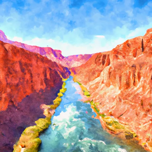
There are several specific river rapids and obstacles to navigate along the Whitewater River Run, including Grapevine, Tanner, Hance, and Crystal Rapids. Grapevine Rapid is a Class III rapid with waves that can reach up to 6 feet in height. Tanner Rapid is a Class IV rapid that contains a large hole that can be challenging to navigate. Hance Rapid is considered one of the most difficult rapids on the river, with a Class IV+ rating and a steep drop that requires precise navigation. Crystal Rapid is a Class III rapid that contains several large boulders that must be avoided.
To ensure the safety of all visitors, there are specific regulations in place for the Whitewater River Run. All visitors must have a permit to enter the area, and only motorized rafts or kayaks are allowed. Additionally, visitors must wear a personal flotation device (PFD) at all times while on the river. It is recommended that visitors have previous whitewater experience before attempting this run.
Overall, the Whitewater River Run in Arizona is an exciting adventure for experienced whitewater enthusiasts. With specific regulations in place and several challenging rapids to navigate, visitors must take appropriate safety precautions to ensure a safe and enjoyable experience.
Plan your run down to the hour
Same weather feed Snoflo's iOS app uses -- updated continuously from NOAA / yr.no. Watch the precipitation column on the meteogram; rain ahead of a run typically lifts flows 12-48 hours later depending on the basin.
Next 5 days, hour by hour
Temperature line with weather symbols on top, snow + rain accumulation as columns, humidity as a dotted line.
5-day forecast table
Every 3 hours, broken out across temperature, snow, rain, humidity, and wind. Each cell is colour-coded relative to the column min/max.
| Time | Condition | Temp (°F) | Snow (in) | Rain (in) | Humidity (%) | Wind (mps) | Wind dir |
|---|---|---|---|---|---|---|---|
| Loading detailed forecast… | |||||||
15-day temperature & precipitation
Daily temperatures, snow, and rain projected over the next two weeks -- the upstream story that drives next week's flows.
Regional streamflow levels
USGS streamgauges around Begins 1 Mile Below The Redwall In Both Of The Main Arms To Confluence With The Colorado River -- useful for spotting upstream pulses and gauging which tributary is contributing what.
| Streamgauge | Discharge | View |
|---|---|---|
| Colorado River Near Grand Canyon | 7,220 cfs | → |
| Little Colorado River Abv Mouth Nr Desert View | 206 cfs | → |
| Little Colorado River Near Cameron | · | → |
| Havasu Creek At Supai | 76 cfs | → |
| Kanab Creek Abv Mouth Nr Supai | 5 cfs | → |
| Moenkopi Wash At Moenkopi | 1 cfs | → |
Plan a longer trip
The closest boat launches, other paddle runs, and campgrounds so a day on the water can grow into a full weekend.
Other river runs
- Begins 2.3 Miles Upstream From Confluence With Colorado River To Confluence With The Colorado River
- The Redwall To Confluence With The Colorado River
- The Base Of The Redwall To Confluence With The Colorado River
Whitewater safety
- Check the flow before you run
- Use the linked-gauge card and Regional Flow panel above. Class ratings change with flow -- a Class III at low water can become Class IV+ at high water.
- Know your skill ceiling
- Pick runs comfortably below your ceiling. Cold-water and big-water runs raise the consequences of any mistake.
- Wear the right gear
- Helmet, PFD, drysuit / wetsuit when water is below 60°F. Throw bag, knife, and whistle on your person, not in the boat.
- Scout, set safety, and run with a team
- Scout new rapids on foot, set safety with throw bags above the consequence pool, and run with at least one other competent paddler.
- Respect the river
- Strainers, undercuts, low-head dams, and wood can kill at any class rating. When in doubt, portage.
Set push alerts in the Snoflo app
Save Begins 1 Mile Below The Redwall In Both Of The Main Arms To Confluence With The Colorado River as a favorite, set a discharge threshold (e.g. "alert me when flow hits 600 cfs"), and the iOS app pushes the moment the linked gauge crosses.
About Begins 1 Mile Below The Redwall In Both Of The Main Arms To Confluence With The Colorado River
What's the optimal flow for Begins 1 Mile Below The Redwall In Both Of The Main Arms To Confluence With The Colorado River?
The optimal flow depends on the section and the craft. Check the Run Details panel for the linked gauge and current status.
How fresh is the cfs reading on this page?
The linked USGS streamgauge reports continuously (every 15 minutes); Snoflo refreshes throughout the day. Hover the streamflow sparkline to read individual datapoints.
What's the whitewater class?
See the Run Details panel for the class rating Snoflo tracks for this run. Class ratings change with flow -- a Class III at low water can become Class IV in high water.
Where do I put in / take out?
Tap Directions in the hero above to open driving directions to the put-in. For shuttle planning, check the Nearby Boat Launches panel and the river run operator's site.
Can I get alerts when flows hit the optimal range?
Yes -- alerts are managed in the Snoflo iOS app. Favorite this run, set a discharge threshold, and you'll get a push the moment the gauge crosses.
Other runs near here
Snoflo-tracked paddle runs within driving distance of Begins 1 Mile Below The Redwall In Both Of The Main Arms To Confluence With The Colorado River.