North Fork Illinois Bayou To Headwaters Below Pedestal Rock River Run
Community Reviews
Been here? Share the conditions.
Reviews, ratings & photos are added in the free Snoflo iOS app — rate a spot, tag the conditions, and your visit is verified by location. Add or manage your reviews from the app.
North Fork Illinois Bayou To Headwaters Below Pedestal Rock
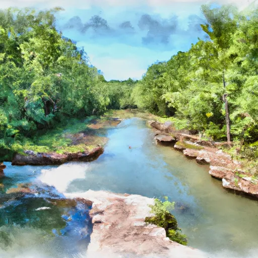
The segment mileage for this run is 10 miles, which takes approximately 5-6 hours to complete. The river rapids and obstacles to watch out for on this run include Big Shoals, Camel Rock, and Pedestal Rock. These rapids offer exciting challenges for experienced paddlers, but also have bypass routes for those who prefer a less challenging route.
There are specific regulations that must be followed when paddling on this river. All paddlers are required to wear a personal flotation device at all times while on the river. Additionally, all paddlers must adhere to Leave No Trace principles, meaning that they should pack out all trash and avoid damaging the surrounding environment.
Overall, the Whitewater River Run from North Fork Illinois Bayou to Headwaters Below Pedestal Rock offers a thrilling whitewater experience for intermediate to advanced paddlers. With its ideal streamflow range, challenging rapids, and beautiful scenery, it is no wonder why this run is a popular destination for whitewater enthusiasts.
Plan your run down to the hour
Same weather feed Snoflo's iOS app uses -- updated continuously from NOAA / yr.no. Watch the precipitation column on the meteogram; rain ahead of a run typically lifts flows 12-48 hours later depending on the basin.
Next 5 days, hour by hour
Temperature line with weather symbols on top, snow + rain accumulation as columns, humidity as a dotted line.
5-day forecast table
Every 3 hours, broken out across temperature, snow, rain, humidity, and wind. Each cell is colour-coded relative to the column min/max.
| Time | Condition | Temp (°F) | Snow (in) | Rain (in) | Humidity (%) | Wind (mps) | Wind dir |
|---|---|---|---|---|---|---|---|
| Loading detailed forecast… | |||||||
15-day temperature & precipitation
Daily temperatures, snow, and rain projected over the next two weeks -- the upstream story that drives next week's flows.
Regional streamflow levels
USGS streamgauges around North Fork Illinois Bayou To Headwaters Below Pedestal Rock -- useful for spotting upstream pulses and gauging which tributary is contributing what.
| Streamgauge | Discharge | View |
|---|---|---|
| Richland Creek Near Witts Spring | 18 cfs | → |
| Big Piney Creek At Highway 164 Near Dover | 6 cfs | → |
| Illinois Bayou Near Scottsville | 5 cfs | → |
| Bear Creek Near Silver Hill | 13 cfs | → |
| Buffalo River Near St. Joe | 107 cfs | → |
| Buffalo River Near Boxley | 7 cfs | → |
Plan a longer trip
The closest boat launches, other paddle runs, and campgrounds so a day on the water can grow into a full weekend.
Other river runs
- Headwaters Sec 2, T2n, R18w To Forest Road 132c
- Forest Road 132c To Forest Raod 179
- Forest Road 179 To East Line Of Nw 1/4 Sec 22, T2n, R17w
- East Line Of Nw 1/4, Sec 22, T2n, R17w To West Line Of Sec 26, T2n, R17w
- Lake Winona Dam To Southern Line Of Sec 16, T2n, R17w
Campgrounds
- Richland Creek Recreation Area
- Richland Creek
- Sam's Throne Campsite
- Haw Creek Falls
- Haw Creek Falls Point Of Interest
- Long Pool
Fishing spots
Whitewater safety
- Check the flow before you run
- Use the linked-gauge card and Regional Flow panel above. Class ratings change with flow -- a Class III at low water can become Class IV+ at high water.
- Know your skill ceiling
- Pick runs comfortably below your ceiling. Cold-water and big-water runs raise the consequences of any mistake.
- Wear the right gear
- Helmet, PFD, drysuit / wetsuit when water is below 60°F. Throw bag, knife, and whistle on your person, not in the boat.
- Scout, set safety, and run with a team
- Scout new rapids on foot, set safety with throw bags above the consequence pool, and run with at least one other competent paddler.
- Respect the river
- Strainers, undercuts, low-head dams, and wood can kill at any class rating. When in doubt, portage.
Set push alerts in the Snoflo app
Save North Fork Illinois Bayou To Headwaters Below Pedestal Rock as a favorite, set a discharge threshold (e.g. "alert me when flow hits 600 cfs"), and the iOS app pushes the moment the linked gauge crosses.
About North Fork Illinois Bayou To Headwaters Below Pedestal Rock
What's the optimal flow for North Fork Illinois Bayou To Headwaters Below Pedestal Rock?
The optimal flow depends on the section and the craft. Check the Run Details panel for the linked gauge and current status.
How fresh is the cfs reading on this page?
The linked USGS streamgauge reports continuously (every 15 minutes); Snoflo refreshes throughout the day. Hover the streamflow sparkline to read individual datapoints.
What's the whitewater class?
See the Run Details panel for the class rating Snoflo tracks for this run. Class ratings change with flow -- a Class III at low water can become Class IV in high water.
Where do I put in / take out?
Tap Directions in the hero above to open driving directions to the put-in. For shuttle planning, check the Nearby Boat Launches panel and the river run operator's site.
Can I get alerts when flows hit the optimal range?
Yes -- alerts are managed in the Snoflo iOS app. Favorite this run, set a discharge threshold, and you'll get a push the moment the gauge crosses.
Other runs near here
Snoflo-tracked paddle runs within driving distance of North Fork Illinois Bayou To Headwaters Below Pedestal Rock.