7 Miles From Isabella Dam To 20.2 Miles From Isabella Dam River Run
Community Reviews
Been here? Share the conditions.
Reviews, ratings & photos are added in the free Snoflo iOS app — rate a spot, tag the conditions, and your visit is verified by location. Add or manage your reviews from the app.
7 Miles From Isabella Dam To 20.2 Miles From Isabella Dam
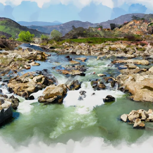
The segment mileage for this section is 13.2 miles, and there are various rapids and obstacles to watch out for, including Funnel Falls, Deadman's Drop, and Pinball. Funnel Falls is a Class III+ rapid that requires precise maneuvering through a narrow chute. Deadman's Drop is a steep, technical rapid that requires a strategic approach. Pinball is a boulder garden that challenges paddlers to navigate through a maze of rocks.
There are specific regulations in place for the Whitewater River Run. All boaters are required to wear a properly fitting personal flotation device (PFD) at all times while on the river. Additionally, it is prohibited to operate any vessel while under the influence of drugs or alcohol. Anyone under the age of 18 must have parental consent and wear a PFD at all times.
In summary, the Whitewater River Run is a thrilling rafting experience with an ideal streamflow range of 800-2,000 cfs. It is rated as Class III and spans 13.2 miles with challenging rapids such as Funnel Falls, Deadman's Drop, and Pinball. Specific regulations are in place, including wearing a proper PFD and not operating a vessel while under the influence.
Plan your run down to the hour
Same weather feed Snoflo's iOS app uses -- updated continuously from NOAA / yr.no. Watch the precipitation column on the meteogram; rain ahead of a run typically lifts flows 12-48 hours later depending on the basin.
Next 5 days, hour by hour
Temperature line with weather symbols on top, snow + rain accumulation as columns, humidity as a dotted line.
5-day forecast table
Every 3 hours, broken out across temperature, snow, rain, humidity, and wind. Each cell is colour-coded relative to the column min/max.
| Time | Condition | Temp (°F) | Snow (in) | Rain (in) | Humidity (%) | Wind (mps) | Wind dir |
|---|---|---|---|---|---|---|---|
| Loading detailed forecast… | |||||||
15-day temperature & precipitation
Daily temperatures, snow, and rain projected over the next two weeks -- the upstream story that drives next week's flows.
Regional streamflow levels
USGS streamgauges around 7 Miles From Isabella Dam To 20.2 Miles From Isabella Dam -- useful for spotting upstream pulses and gauging which tributary is contributing what.
| Streamgauge | Discharge | View |
|---|---|---|
| Deer C Nr Fountain Springs Ca | 5 cfs | → |
| Sf Kern R Nr Onyx Ca | 21 cfs | → |
| Sf Tule R Nr Reservation Bndry Nr Porterville Ca | 9 cfs | → |
| Sf Tule R Nr Cholollo Campground Nr Porterville Ca | 8 cfs | → |
| Piru C Ab Frenchmans Flat Ca | 16 cfs | → |
| Piru Creek Above Lake Piru Ca | 18 cfs | → |
Plan a longer trip
The closest boat launches, other paddle runs, and campgrounds so a day on the water can grow into a full weekend.
Boat launches
- Democrat Raft Take-Out Boating Site
- Delonegha River Access Boating Site
- Kern Canyon Road Bodfish
- Miracle Hot Springs Picnic Site
- Sandy Flat Put-In/Take-Out Boating Site
Other river runs
- 20.2 Miles Downstream Of Isabella Dam To Western Nf Boundary
- Sandy Flat Camp To Democrat Picnic Area
- Isabella Lake Dam To 7 Miles Downstream
- Southern Boundary Of Wsr To Nf Boundary
- Camp Wishon To Confluence With Middle Fork Tule River
Campgrounds
Fishing spots
Whitewater safety
- Check the flow before you run
- Use the linked-gauge card and Regional Flow panel above. Class ratings change with flow -- a Class III at low water can become Class IV+ at high water.
- Know your skill ceiling
- Pick runs comfortably below your ceiling. Cold-water and big-water runs raise the consequences of any mistake.
- Wear the right gear
- Helmet, PFD, drysuit / wetsuit when water is below 60°F. Throw bag, knife, and whistle on your person, not in the boat.
- Scout, set safety, and run with a team
- Scout new rapids on foot, set safety with throw bags above the consequence pool, and run with at least one other competent paddler.
- Respect the river
- Strainers, undercuts, low-head dams, and wood can kill at any class rating. When in doubt, portage.
Set push alerts in the Snoflo app
Save 7 Miles From Isabella Dam To 20.2 Miles From Isabella Dam as a favorite, set a discharge threshold (e.g. "alert me when flow hits 600 cfs"), and the iOS app pushes the moment the linked gauge crosses.
About 7 Miles From Isabella Dam To 20.2 Miles From Isabella Dam
What's the optimal flow for 7 Miles From Isabella Dam To 20.2 Miles From Isabella Dam?
The optimal flow depends on the section and the craft. Check the Run Details panel for the linked gauge and current status.
How fresh is the cfs reading on this page?
The linked USGS streamgauge reports continuously (every 15 minutes); Snoflo refreshes throughout the day. Hover the streamflow sparkline to read individual datapoints.
What's the whitewater class?
See the Run Details panel for the class rating Snoflo tracks for this run. Class ratings change with flow -- a Class III at low water can become Class IV in high water.
Where do I put in / take out?
Tap Directions in the hero above to open driving directions to the put-in. For shuttle planning, check the Nearby Boat Launches panel and the river run operator's site.
Can I get alerts when flows hit the optimal range?
Yes -- alerts are managed in the Snoflo iOS app. Favorite this run, set a discharge threshold, and you'll get a push the moment the gauge crosses.
Other runs near here
Snoflo-tracked paddle runs within driving distance of 7 Miles From Isabella Dam To 20.2 Miles From Isabella Dam.