Wilderness Boundary To Confluence With Gold Hill Creek River Run
Community Reviews
Been here? Share the conditions.
Reviews, ratings & photos are added in the free Snoflo iOS app — rate a spot, tag the conditions, and your visit is verified by location. Add or manage your reviews from the app.
Wilderness Boundary To Confluence With Gold Hill Creek
The class rating for this segment is Class III, with several technical rapids and obstacles. Some of the notable rapids include "Sundance," "The Squeeze," and "The Chute." It is recommended that only experienced boaters attempt this run, as the rapids can be challenging and require a high level of skill.
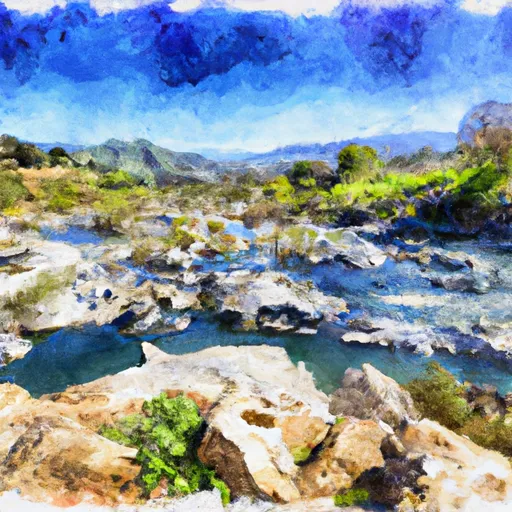
The total mileage of this segment is approximately 6.5 miles. The run begins at the Whitewater River Wilderness Boundary and ends at the confluence with Gold Hill Creek. The scenery along the way is stunning, with towering cliffs and lush vegetation lining the riverbanks.
There are specific regulations that must be followed when boating on this section of the Whitewater River. All boaters are required to wear personal floatation devices and adhere to safe boating practices. Additionally, permits are required for commercial boating operations.
In conclusion, the Whitewater River Run Wilderness Boundary to Confluence with Gold Hill Creek in California is an exciting and challenging stretch of river. Boaters should be experienced and prepared for technical rapids and obstacles. The ideal streamflow range is between 200 and 800 cfs, and specific regulations must be followed to ensure the safety of all boaters.
Plan your run down to the hour
Same weather feed Snoflo's iOS app uses -- updated continuously from NOAA / yr.no. Watch the precipitation column on the meteogram; rain ahead of a run typically lifts flows 12-48 hours later depending on the basin.
Next 5 days, hour by hour
Temperature line with weather symbols on top, snow + rain accumulation as columns, humidity as a dotted line.
5-day forecast table
Every 3 hours, broken out across temperature, snow, rain, humidity, and wind. Each cell is colour-coded relative to the column min/max.
| Time | Condition | Temp (°F) | Snow (in) | Rain (in) | Humidity (%) | Wind (mps) | Wind dir |
|---|---|---|---|---|---|---|---|
| Loading detailed forecast… | |||||||
15-day temperature & precipitation
Daily temperatures, snow, and rain projected over the next two weeks -- the upstream story that drives next week's flows.
Regional streamflow levels
USGS streamgauges around Wilderness Boundary To Confluence With Gold Hill Creek -- useful for spotting upstream pulses and gauging which tributary is contributing what.
| Streamgauge | Discharge | View |
|---|---|---|
| Piru C Ab Frenchmans Flat Ca | 16 cfs | → |
| Piru Creek Above Lake Piru Ca | 18 cfs | → |
| Sespe C Nr Fillmore | 11 cfs | → |
| Piru Creek Below Santa Felicia Dam Ca | 21 cfs | → |
| Sespe Creek Near Wheeler Springs Ca | 0 cfs | → |
| Santa Paula C Nr Santa Paula | 7 cfs | → |
Plan a longer trip
The closest boat launches, other paddle runs, and campgrounds so a day on the water can grow into a full weekend.
Boat launches
- Pyramid Lake Road, Lebec
- Vista Del Lago Road 21, Lebec
- Vacquero Boating And Picnic Site
- Interstate 5, Lebec
- Lake Piru Recreation Area
- Piru Canyon Road 4780, Castaic
Other river runs
- Confluence With Gold Hill Creek To Castaic
- Castaic To Pyramid Reservoir
- Headwaters, Upper Piru Creek To Wildernes Boundary
- Lower Piru Creek (Oulet At Pyramid Reservoir) To Piru Reservoir
- Section Line To Confluence With Rock Creek
Campgrounds
- Kings Campground
- Kings Camp
- Dutchman Campground
- Sunset Campground
- Hardluck
- Pyramid Lake--Los Alamos Group Campground
Fishing spots
Whitewater safety
- Check the flow before you run
- Use the linked-gauge card and Regional Flow panel above. Class ratings change with flow -- a Class III at low water can become Class IV+ at high water.
- Know your skill ceiling
- Pick runs comfortably below your ceiling. Cold-water and big-water runs raise the consequences of any mistake.
- Wear the right gear
- Helmet, PFD, drysuit / wetsuit when water is below 60°F. Throw bag, knife, and whistle on your person, not in the boat.
- Scout, set safety, and run with a team
- Scout new rapids on foot, set safety with throw bags above the consequence pool, and run with at least one other competent paddler.
- Respect the river
- Strainers, undercuts, low-head dams, and wood can kill at any class rating. When in doubt, portage.
Set push alerts in the Snoflo app
Save Wilderness Boundary To Confluence With Gold Hill Creek as a favorite, set a discharge threshold (e.g. "alert me when flow hits 600 cfs"), and the iOS app pushes the moment the linked gauge crosses.
About Wilderness Boundary To Confluence With Gold Hill Creek
What's the optimal flow for Wilderness Boundary To Confluence With Gold Hill Creek?
The optimal flow depends on the section and the craft. Check the Run Details panel for the linked gauge and current status.
How fresh is the cfs reading on this page?
The linked USGS streamgauge reports continuously (every 15 minutes); Snoflo refreshes throughout the day. Hover the streamflow sparkline to read individual datapoints.
What's the whitewater class?
See the Run Details panel for the class rating Snoflo tracks for this run. Class ratings change with flow -- a Class III at low water can become Class IV in high water.
Where do I put in / take out?
Tap Directions in the hero above to open driving directions to the put-in. For shuttle planning, check the Nearby Boat Launches panel and the river run operator's site.
Can I get alerts when flows hit the optimal range?
Yes -- alerts are managed in the Snoflo iOS app. Favorite this run, set a discharge threshold, and you'll get a push the moment the gauge crosses.
Other runs near here
Snoflo-tracked paddle runs within driving distance of Wilderness Boundary To Confluence With Gold Hill Creek.