Thornhill Broome - Point Mugu State Park Campground
Community Reviews
Been here? Share the conditions.
Reviews, ratings & photos are added in the free Snoflo iOS app — rate a spot, tag the conditions, and your visit is verified by location. Add or manage your reviews from the app.
Thornhill Broome - Point Mugu State Park
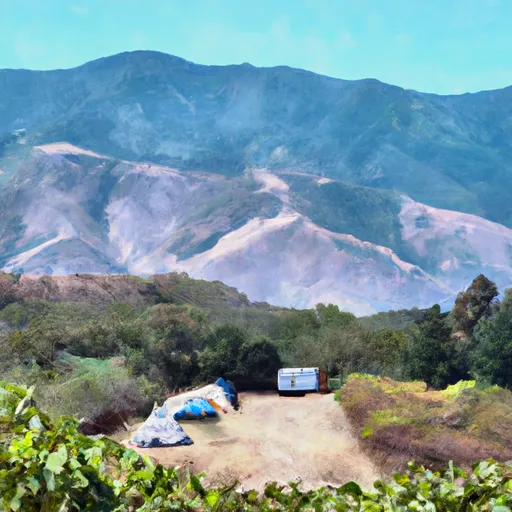
The campground at Thornhill Broome Point Mugu State Park offers amenities such as fire rings, picnic tables, and restrooms. The campground is first-come-first-serve, with 62 campsites available for guests. Additionally, the park offers outdoor activities such as swimming, surfing, and fishing.
An interesting fact about Thornhill Broome Point Mugu State Park is that it was once used as a film location for various movies and TV shows, including The A-Team and Star Trek: Voyager.
The best time to visit Thornhill Broome Point Mugu State Park is during the spring and fall months, where the average temperature ranges from 60-70 degrees Fahrenheit. Summer months can reach higher temperatures, but visitors can still enjoy the cool Pacific breeze from the beachfront location.
In summary, Thornhill Broome Point Mugu State Park camping area offers stunning ocean views, nearby points of interest, first-come-first-serve campsite reservations, 62 campsites, outdoor activities, and was once a popular film location. It is best to visit during spring and fall, with average temperatures ranging from 60-70 degrees Fahrenheit.
What's on-site at Thornhill Broome - Point Mugu State Park
Key facilities Snoflo tracks for this campground. Confirm with the operator before booking -- amenities can change seasonally.
Plan your trip down to the hour
Same weather feed Snoflo's iOS app uses -- updated continuously from NOAA / yr.no.
Next 5 days, hour by hour
Temperature line with weather symbols on top, snow + rain accumulation as columns, humidity as a dotted line.
5-day forecast table
Every 3 hours, broken out across temperature, snow, rain, humidity, and wind. Each cell is colour-coded relative to the column min/max so trends jump out at a glance.
| Time | Condition | Temp (°F) | Snow (in) | Rain (in) | Humidity (%) | Wind (mps) | Wind dir |
|---|---|---|---|---|---|---|---|
| Loading detailed forecast… | |||||||
15-day temperature & precipitation
Daily temperatures, snow, and rain projected over the next two weeks. Hover any point for the full breakdown.
Other campgrounds in the area
Snoflo-tracked campsites within driving distance of Thornhill Broome - Point Mugu State Park, with reservations status.
| Campground | Reservations | Toilets | View |
|---|---|---|---|
| Thornehill Broome Beach Campground | ✗ | ✗ | → |
| Thornhill Broome Beach | ✗ | ✗ | → |
| Thornhill Broome Family | ✗ | ✗ | → |
| La Jolla Canyon Group | ✗ | ✗ | → |
| Big Sycamore Canyon | ✗ | ✗ | → |
Nearby streamflow
USGS streamgauges within reach of Thornhill Broome - Point Mugu State Park -- pulled live from the National Water Information System.
| Streamgauge | Discharge | View |
|---|---|---|
| Calleguas C Nr Camarillo Ca | 6 cfs | → |
| Santa Paula C Nr Santa Paula | 6 cfs | → |
| Ventura R Nr Ventura | 14 cfs | → |
| Sespe C Nr Fillmore | 12 cfs | → |
| Santa Clara R Nr Piru Ca | 32 cfs | → |
| Piru Creek Below Santa Felicia Dam Ca | 21 cfs | → |
Plan a longer trip
The closest parks, lakes, boat launches, and paddle runs so a camping night can grow into a full weekend.
Parks
- Point Mugu State Park
- Santa Monica Mountains National Recreation Area
- Leo Carrillo State Park
- Point Mugu Game Reserve
- Dos Vientos Neighborhood Park
- Ventura County Game Reserve
Boat launches
Fishing spots
Points of interest
- Chumash Demonstration Village
- Sandstone Peak
- Santa Monica College Astronomical Observing Site
- Western Foundation Of Vertebrate Zoology Museum
- Caf Socal
- Camarillo House County Landmark
Paddle runs
- Headwaters In The Santa Monica Mountains To Mouth At Pacific Ocean
- Section Line To Confluence With Rock Creek
- Lower Piru Creek (Oulet At Pyramid Reservoir) To Piru Reservoir
- Chorro Grande Canyon To Section Line Dividing Sec 1, T5n, R23w And Sec 6, T5n, T22w
- Headwaters, Upper Piru Creek To Wildernes Boundary
- Castaic To Pyramid Reservoir
Camping essentials & Leave No Trace
- Pack it in, pack it out
- Take all trash, food scraps, and gear back with you to keep campsites clean and protect wildlife.
- Respect wildlife
- Observe animals from a distance, store food securely, and never feed wildlife to maintain natural behavior and safety.
- Know before you go
- Check weather, fire restrictions, trail conditions, and permit requirements to ensure a safe and well-planned trip.
- Minimize campfire impact
- Use established fire rings, keep fires small, fully extinguish them, or opt for a camp stove when fires are restricted.
- Leave what you find
- Preserve natural and cultural features by avoiding removal of plants, rocks, artifacts, or other elements of the environment.
Set push alerts in the Snoflo app
Save Thornhill Broome - Point Mugu State Park as a favorite, set a custom threshold (precipitation, snowpack, freezing temperatures), and the iOS app will push the moment conditions cross.
About Thornhill Broome - Point Mugu State Park
Can I make reservations at Thornhill Broome - Point Mugu State Park?
Yes -- this campground accepts reservations. Snoflo recommends booking early for peak season; check the operator (Recreation.gov / state park system / private operator) for the booking window and cancellation policy.
How fresh is the weather data on this page?
The hourly forecast updates throughout the day from the NOAA / yr.no public feeds. Streamflow data is pulled live from USGS streamgauges and snowpack from the NRCS SNOTEL network.
What's the best time of year to visit?
Use the 15-day temperature & precipitation outlook on this page to plan -- pick a window with comfortable temperatures and low precipitation. For longer trips, the 5-day hourly meteogram shows snow + rain accumulation hour-by-hour.
How do I get to Thornhill Broome - Point Mugu State Park?
Tap Directions in the hero above to open driving directions in Google Maps, or Open in map to center the Snoflo interactive map on the campground.
Can I get alerts when conditions change?
Yes -- alerts are managed through the Snoflo iOS app. Favorite this campground, set a threshold (temperature, snowpack, precipitation), and you'll get a push the moment it crosses.
Other campgrounds near here
Snoflo-tracked campgrounds within driving distance of Thornhill Broome - Point Mugu State Park.