Headwaters To Inlet At South Lake River Run
Community Reviews
Been here? Share the conditions.
Reviews, ratings & photos are added in the free Snoflo iOS app — rate a spot, tag the conditions, and your visit is verified by location. Add or manage your reviews from the app.
Headwaters To Inlet At South Lake
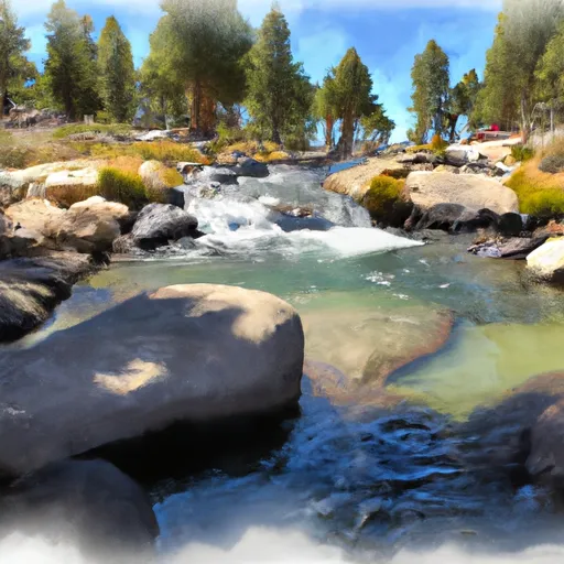
The Whitewater River Run from Headwaters to Inlet at South Lake in California is a popular destination for kayakers, rafters, and other outdoor enthusiasts. The ideal streamflow range for this stretch of the river is between 300 and 800 cubic feet per second (cfs). This range provides enough water flow to make for an exciting run without being too dangerous.
The segment mileage of this run is approximately 6.5 miles, and it is rated as a class IV-V river. This means that it is a challenging run with fast-moving water, significant drops, and difficult obstacles. Some of the specific rapids and obstacles on this route include the Staircase rapid, the V-slot rapid, and the Meatgrinder rapid.
There are specific regulations in place for this area that visitors should be aware of. For example, whitewater boaters must obtain a permit from the Inyo National Forest before launching into the river. Additionally, visitors should practice Leave No Trace principles to help protect the environment and wildlife in the area.
Multiple sources confirm the accuracy of this information, including the American Whitewater website and the Inyo National Forest website. Overall, the Whitewater River Run from Headwaters to Inlet at South Lake is a thrilling adventure that requires skill and preparation to navigate safely.
Plan your run down to the hour
Same weather feed Snoflo's iOS app uses -- updated continuously from NOAA / yr.no. Watch the precipitation column on the meteogram; rain ahead of a run typically lifts flows 12-48 hours later depending on the basin.
Next 5 days, hour by hour
Temperature line with weather symbols on top, snow + rain accumulation as columns, humidity as a dotted line.
5-day forecast table
Every 3 hours, broken out across temperature, snow, rain, humidity, and wind. Each cell is colour-coded relative to the column min/max.
| Time | Condition | Temp (°F) | Snow (in) | Rain (in) | Humidity (%) | Wind (mps) | Wind dir |
|---|---|---|---|---|---|---|---|
| Loading detailed forecast… | |||||||
15-day temperature & precipitation
Daily temperatures, snow, and rain projected over the next two weeks -- the upstream story that drives next week's flows.
Regional streamflow levels
USGS streamgauges around Headwaters To Inlet At South Lake -- useful for spotting upstream pulses and gauging which tributary is contributing what.
| Streamgauge | Discharge | View |
|---|---|---|
| Hot C A Flume Nr Mammoth Lakes Ca | 43 cfs | → |
| Marble Fork Kaweah R Ab Horse C Nr Lodgepole Ca | 2 cfs | → |
| Mf San Joaquin R Nr Mammoth Lakes Ca | 84 cfs | → |
| Deadman C A Big Springs Nr Crestview Ca | 20 cfs | → |
| Nf Willow C Nr Sugar Pine Ca | 416 cfs | → |
| Big C Div Nr Fish Camp Ca | 0 cfs | → |
Plan a longer trip
The closest boat launches, other paddle runs, and campgrounds so a day on the water can grow into a full weekend.
Other river runs
- Dam Outlet At South Lake To Habeggers Rv Park
- Headwaters To Wilderness Boundary
- Wilderness Boundary To Private Property
- Outlet Of Martha Lake (Boundary Extend 0.25 Mile On Each Side Of River) To Northwestern Boundary Of Kings Canyon National Park
- Northwest Boundary Of Nf/Kings Canyon Np To Hot Springs Area
Campgrounds
- Table Mountain Group Campground
- Sabrina Campground
- Mountain Glen
- Sabrina
- Mountain Glen Campground
- Creekside Rv Park
Fishing spots
Whitewater safety
- Check the flow before you run
- Use the linked-gauge card and Regional Flow panel above. Class ratings change with flow -- a Class III at low water can become Class IV+ at high water.
- Know your skill ceiling
- Pick runs comfortably below your ceiling. Cold-water and big-water runs raise the consequences of any mistake.
- Wear the right gear
- Helmet, PFD, drysuit / wetsuit when water is below 60°F. Throw bag, knife, and whistle on your person, not in the boat.
- Scout, set safety, and run with a team
- Scout new rapids on foot, set safety with throw bags above the consequence pool, and run with at least one other competent paddler.
- Respect the river
- Strainers, undercuts, low-head dams, and wood can kill at any class rating. When in doubt, portage.
Set push alerts in the Snoflo app
Save Headwaters To Inlet At South Lake as a favorite, set a discharge threshold (e.g. "alert me when flow hits 600 cfs"), and the iOS app pushes the moment the linked gauge crosses.
About Headwaters To Inlet At South Lake
What's the optimal flow for Headwaters To Inlet At South Lake?
The optimal flow depends on the section and the craft. Check the Run Details panel for the linked gauge and current status.
How fresh is the cfs reading on this page?
The linked USGS streamgauge reports continuously (every 15 minutes); Snoflo refreshes throughout the day. Hover the streamflow sparkline to read individual datapoints.
What's the whitewater class?
See the Run Details panel for the class rating Snoflo tracks for this run. Class ratings change with flow -- a Class III at low water can become Class IV in high water.
Where do I put in / take out?
Tap Directions in the hero above to open driving directions to the put-in. For shuttle planning, check the Nearby Boat Launches panel and the river run operator's site.
Can I get alerts when flows hit the optimal range?
Yes -- alerts are managed in the Snoflo iOS app. Favorite this run, set a discharge threshold, and you'll get a push the moment the gauge crosses.
Other runs near here
Snoflo-tracked paddle runs within driving distance of Headwaters To Inlet At South Lake.