Ladwp Property To Wilderness Boundary River Run
Community Reviews
Been here? Share the conditions.
Reviews, ratings & photos are added in the free Snoflo iOS app — rate a spot, tag the conditions, and your visit is verified by location. Add or manage your reviews from the app.
Ladwp Property To Wilderness Boundary
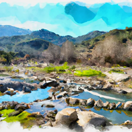
Some of the specific river rapids and obstacles on this run include "The Chute," "Rockpile," and "Three-Drop." These rapids require technical skill and are known for their intense waves and drops. However, there are also calm sections of the river that provide an opportunity to relax and take in the scenic surroundings.
It is important to note that there are specific regulations in place for this area. Boaters are required to obtain a permit from the Bureau of Land Management, and all boaters must wear a life jacket at all times while on the river. Additionally, the use of alcohol and drugs is strictly prohibited.
Overall, the Whitewater River Run offers a challenging yet scenic kayaking experience for intermediate-level paddlers. With its unique rapids, ideal streamflow range, and specific regulations, this run is a must-visit for any avid kayaker in the Palm Springs area.
Plan your run down to the hour
Same weather feed Snoflo's iOS app uses -- updated continuously from NOAA / yr.no. Watch the precipitation column on the meteogram; rain ahead of a run typically lifts flows 12-48 hours later depending on the basin.
Next 5 days, hour by hour
Temperature line with weather symbols on top, snow + rain accumulation as columns, humidity as a dotted line.
5-day forecast table
Every 3 hours, broken out across temperature, snow, rain, humidity, and wind. Each cell is colour-coded relative to the column min/max.
| Time | Condition | Temp (°F) | Snow (in) | Rain (in) | Humidity (%) | Wind (mps) | Wind dir |
|---|---|---|---|---|---|---|---|
| Loading detailed forecast… | |||||||
15-day temperature & precipitation
Daily temperatures, snow, and rain projected over the next two weeks -- the upstream story that drives next week's flows.
Regional streamflow levels
USGS streamgauges around Ladwp Property To Wilderness Boundary -- useful for spotting upstream pulses and gauging which tributary is contributing what.
| Streamgauge | Discharge | View |
|---|---|---|
| Marble Fork Kaweah R Ab Horse C Nr Lodgepole Ca | 1 cfs | → |
| Sf Tule R Nr Cholollo Campground Nr Porterville Ca | 8 cfs | → |
| Sf Kern R Nr Onyx Ca | 19 cfs | → |
| Sf Tule R Nr Reservation Bndry Nr Porterville Ca | 10 cfs | → |
| Deer C Nr Fountain Springs Ca | 6 cfs | → |
| Hot C A Flume Nr Mammoth Lakes Ca | 46 cfs | → |
Plan a longer trip
The closest boat launches, other paddle runs, and campgrounds so a day on the water can grow into a full weekend.
Other river runs
- Wilderness Boundary To Intake
- Forest Road 16so2 To La Dept. Of Water And Power Property
- Headwaters To Forest Road 16s02
- Wilderness Boundary To Nf Boundary
- Tributary Headwaters To Wilderness Boundary
Campgrounds
- Diaz Creek
- Cottonwood Lakes Walk In Campground
- Cottonwood Pass Walk In Campground
- Golden Trout Camp
- Chicken Spring Lake Camp Area 11,240ft.
- Diaz Lake
Fishing spots
- Cottonwood Creek Lower Lone Pine
- South Fork Cottonwood Creek
- Muir Lake
- Cottonwood Lakes
- High Lake
- Peanut Lake
Parks
Whitewater safety
- Check the flow before you run
- Use the linked-gauge card and Regional Flow panel above. Class ratings change with flow -- a Class III at low water can become Class IV+ at high water.
- Know your skill ceiling
- Pick runs comfortably below your ceiling. Cold-water and big-water runs raise the consequences of any mistake.
- Wear the right gear
- Helmet, PFD, drysuit / wetsuit when water is below 60°F. Throw bag, knife, and whistle on your person, not in the boat.
- Scout, set safety, and run with a team
- Scout new rapids on foot, set safety with throw bags above the consequence pool, and run with at least one other competent paddler.
- Respect the river
- Strainers, undercuts, low-head dams, and wood can kill at any class rating. When in doubt, portage.
Set push alerts in the Snoflo app
Save Ladwp Property To Wilderness Boundary as a favorite, set a discharge threshold (e.g. "alert me when flow hits 600 cfs"), and the iOS app pushes the moment the linked gauge crosses.
About Ladwp Property To Wilderness Boundary
What's the optimal flow for Ladwp Property To Wilderness Boundary?
The optimal flow depends on the section and the craft. Check the Run Details panel for the linked gauge and current status.
How fresh is the cfs reading on this page?
The linked USGS streamgauge reports continuously (every 15 minutes); Snoflo refreshes throughout the day. Hover the streamflow sparkline to read individual datapoints.
What's the whitewater class?
See the Run Details panel for the class rating Snoflo tracks for this run. Class ratings change with flow -- a Class III at low water can become Class IV in high water.
Where do I put in / take out?
Tap Directions in the hero above to open driving directions to the put-in. For shuttle planning, check the Nearby Boat Launches panel and the river run operator's site.
Can I get alerts when flows hit the optimal range?
Yes -- alerts are managed in the Snoflo iOS app. Favorite this run, set a discharge threshold, and you'll get a push the moment the gauge crosses.
Other runs near here
Snoflo-tracked paddle runs within driving distance of Ladwp Property To Wilderness Boundary.