Falls To Gold Lake Highway River Run
Community Reviews
Been here? Share the conditions.
Reviews, ratings & photos are added in the free Snoflo iOS app — rate a spot, tag the conditions, and your visit is verified by location. Add or manage your reviews from the app.
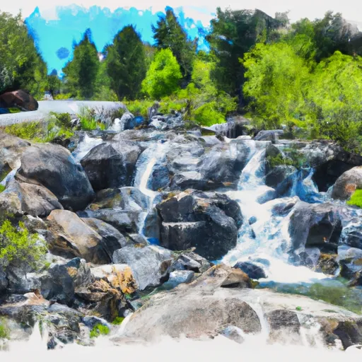
Falls To Gold Lake Highway
Some of the notable river rapids and obstacles in this section include the Toilet Bowl, which is a swirling rapid that can be challenging to navigate, and the S-Turns, which consist of a series of tight turns that require precise maneuvering. Other obstacles include boulders, drops, and waves, which can provide a thrilling and exhilarating experience for rafters.
There are specific regulations that apply to the Whitewater River Run, including restrictions on the use of alcohol and drugs, as well as the requirement that all participants wear appropriate safety gear, including helmets and life jackets. Additionally, there may be restrictions on the number of participants allowed on the river at any given time, so it is important to check with the local authorities before planning a rafting trip. Overall, the Whitewater River Run is an exciting and challenging destination for experienced whitewater rafters, and it is important to take all necessary safety precautions to ensure a safe and enjoyable trip.
Plan your run down to the hour
Same weather feed Snoflo's iOS app uses -- updated continuously from NOAA / yr.no. Watch the precipitation column on the meteogram; rain ahead of a run typically lifts flows 12-48 hours later depending on the basin.
Next 5 days, hour by hour
Temperature line with weather symbols on top, snow + rain accumulation as columns, humidity as a dotted line.
5-day forecast table
Every 3 hours, broken out across temperature, snow, rain, humidity, and wind. Each cell is colour-coded relative to the column min/max.
| Time | Condition | Temp (°F) | Snow (in) | Rain (in) | Humidity (%) | Wind (mps) | Wind dir |
|---|---|---|---|---|---|---|---|
| Loading detailed forecast… | |||||||
15-day temperature & precipitation
Daily temperatures, snow, and rain projected over the next two weeks -- the upstream story that drives next week's flows.
Regional streamflow levels
USGS streamgauges around Falls To Gold Lake Highway -- useful for spotting upstream pulses and gauging which tributary is contributing what.
| Streamgauge | Discharge | View |
|---|---|---|
| Spanish C A Quincy Ca | 16 cfs | → |
| N Yuba R Bl Goodyears Bar Ca | 165 cfs | → |
| Little Truckee R Bl Div Dam Nr Sierraville Ca | 3 cfs | → |
| Spanish C Ab Blackhawk C At Keddie Ca | 34 cfs | → |
| Independence C Nr Truckee Ca | 6 cfs | → |
| Sagehen C Nr Truckee Ca | 2 cfs | → |
Plan a longer trip
The closest boat launches, other paddle runs, and campgrounds so a day on the water can grow into a full weekend.
Boat launches
- Gold Lake
- Salmon Lake -Boat Ramp Boating Site
- Salmon Lake Road 1500, Sierra City
- Packer Lake Lodge
- Sardine Lake Road 990, Sierra City
- Lake Davis Recreation Area (Old Camp Five)
Other river runs
- Gold Lake Highway To Nf Boundary
- Gold Lake Dam To Falls
- Little Jamison Creek Headwaters To State Park
- Headwaters To State Park
- State Park To Confluence With Middle Fork Feather Wsr
Campgrounds
- Rivers Rv Park
- Lakes Basin Group Campground
- Lakes Basin Campground
- Lakes Basin .
- Gold Lake 4x4
- Plumas - Eureka State Park
Fishing spots
Whitewater safety
- Check the flow before you run
- Use the linked-gauge card and Regional Flow panel above. Class ratings change with flow -- a Class III at low water can become Class IV+ at high water.
- Know your skill ceiling
- Pick runs comfortably below your ceiling. Cold-water and big-water runs raise the consequences of any mistake.
- Wear the right gear
- Helmet, PFD, drysuit / wetsuit when water is below 60°F. Throw bag, knife, and whistle on your person, not in the boat.
- Scout, set safety, and run with a team
- Scout new rapids on foot, set safety with throw bags above the consequence pool, and run with at least one other competent paddler.
- Respect the river
- Strainers, undercuts, low-head dams, and wood can kill at any class rating. When in doubt, portage.
Set push alerts in the Snoflo app
Save Falls To Gold Lake Highway as a favorite, set a discharge threshold (e.g. "alert me when flow hits 600 cfs"), and the iOS app pushes the moment the linked gauge crosses.
About Falls To Gold Lake Highway
What's the optimal flow for Falls To Gold Lake Highway?
The optimal flow depends on the section and the craft. Check the Run Details panel for the linked gauge and current status.
How fresh is the cfs reading on this page?
The linked USGS streamgauge reports continuously (every 15 minutes); Snoflo refreshes throughout the day. Hover the streamflow sparkline to read individual datapoints.
What's the whitewater class?
See the Run Details panel for the class rating Snoflo tracks for this run. Class ratings change with flow -- a Class III at low water can become Class IV in high water.
Where do I put in / take out?
Tap Directions in the hero above to open driving directions to the put-in. For shuttle planning, check the Nearby Boat Launches panel and the river run operator's site.
Can I get alerts when flows hit the optimal range?
Yes -- alerts are managed in the Snoflo iOS app. Favorite this run, set a discharge threshold, and you'll get a push the moment the gauge crosses.
Other runs near here
Snoflo-tracked paddle runs within driving distance of Falls To Gold Lake Highway.