Plumas County Boat Launch
Community Reviews
Been here? Share the conditions.
Reviews, ratings & photos are added in the free Snoflo iOS app — rate a spot, tag the conditions, and your visit is verified by location. Add or manage your reviews from the app.
Plumas County
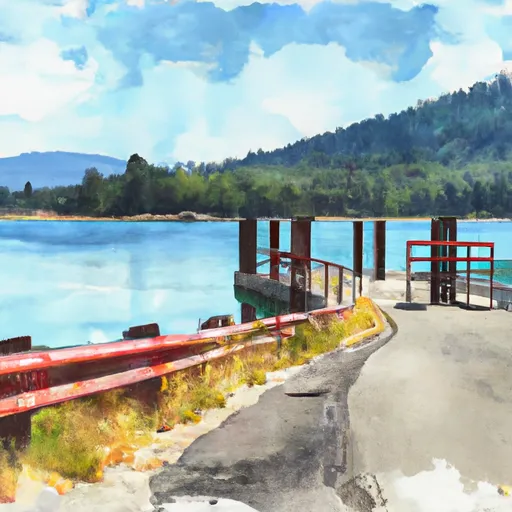
According to the latest information available, the Plumas County boat ramp is a concrete ramp that is suitable for launching both motorized and non-motorized boats. The ramp is approximately 15 feet wide and has a gentle slope, making it easy for boaters to launch and retrieve their vessels.
Lake Davis, which the boat ramp services, is a 4,000-acre reservoir located in Plumas National Forest. The lake is known for its excellent trout fishing and is a popular destination for boating, kayaking, and other water sports. However, it is important to note that Lake Davis has specific regulations regarding the types of watercraft that are permitted on the lake. Only vessels that are 16 feet or longer and have an enclosed engine compartment are allowed on the lake. Additionally, all boats must be inspected for invasive species before being launched.
In summary, the Plumas County boat ramp in California is a concrete ramp that is suitable for launching both motorized and non-motorized boats. It is approximately 15 feet wide and provides access to Lake Davis, a 4,000-acre reservoir in Plumas National Forest. However, boaters should note that only certain types of watercraft are permitted on the lake and all boats must be inspected for invasive species before being launched.
Plan your launch down to the hour
Same weather feed Snoflo's iOS app uses -- updated continuously from NOAA / yr.no.
Next 5 days, hour by hour
Temperature line with weather symbols on top, snow + rain accumulation as columns, humidity as a dotted line.
5-day forecast table
Every 3 hours, broken out across temperature, snow, rain, humidity, and wind.
| Time | Condition | Temp (°F) | Snow (in) | Rain (in) | Humidity (%) | Wind (mps) | Wind dir |
|---|---|---|---|---|---|---|---|
| Loading detailed forecast… | |||||||
15-day temperature & precipitation
Daily temperatures, snow, and rain projected over the next two weeks.
Area streamflow levels
USGS streamgauges around Plumas County -- the same readings that determine whether your launch is safe and your boat is the right craft.
| Streamgauge | Discharge | View |
|---|---|---|
| N Yuba R Bl Goodyears Bar Ca | 137 cfs | → |
| Spanish C A Quincy Ca | 13 cfs | → |
| Spanish C Ab Blackhawk C At Keddie Ca | 21 cfs | → |
Plan a longer trip
The closest paddle runs, fishing spots, and other boat launches so you can extend a day on the water.
River runs
- Chicago Ravine To Confluence With Middle Fork Feather Wsr
- Headwaters To Chicago Ravine
- Headwaters To Middle Fork Feather Wsr
- Confluence Of Morrow Creek And Third Water Creek To Confluence With Middle Fork Feather River
- Headwaters At West Branch Canyon Creek (Sec 26, T22n, R10e) To Confluence With Canyon Creek
- Headwaters To Slate Reservoir
Nearby fishing
Boating safety & etiquette
- Check the conditions before you launch
- Use the streamflow numbers, weather, and wind forecast on this page. High-cfs whitewater requires whitewater-specific craft and skill.
- Wear your life jacket
- Statistically the single biggest survival factor in a boating incident. State law often requires one per passenger.
- File a float plan
- Tell someone on shore your put-in, take-out, and expected return time. Especially for multi-day or remote trips.
- Yield at the ramp
- Prep gear in the parking lot, not on the ramp. Launch and clear quickly so others can use the lane.
- Clean, drain, dry
- Inspect, clean, drain and dry your boat between waters to prevent the spread of aquatic invasive species.
Set push alerts in the Snoflo app
Save Plumas County as a favorite, set a discharge threshold or a wind/precipitation alert, and the iOS app will push the moment conditions cross.
About Plumas County
Can I launch a motorboat here?
Most Snoflo-tracked launches support motorboats; check the operator for any horsepower restrictions, paddle-only zones, or seasonal closures.
How fresh is the streamflow data?
USGS streamgauges report continuously (every 15 minutes); the table on this page pulls the latest reading at page load.
Is there a fee?
Many federal and state boat launches charge a day-use fee. Check the operator's site before driving out.
What boat is right for these conditions?
Use the nearby streamflow numbers and river-run panel on this page to gauge current conditions. Wider, slower water is friendly for casual paddling and powerboats; high-cfs whitewater requires whitewater-specific craft and skill.
Can I get alerts when conditions change?
Yes -- alerts are managed in the Snoflo iOS app. Favorite this launch, set a threshold (discharge, wind), and you'll get a push the moment it crosses.
Other launches near here
Snoflo-tracked boat launches within driving distance of Plumas County.