Section Line To Confluence With Rock Creek river run
Community Reviews
Been here? Share the conditions.
Reviews, ratings & photos are added in the free Snoflo iOS app — rate a spot, tag the conditions, and your visit is verified by location. Add or manage your reviews from the app.
Section Line To Confluence With Rock Creek
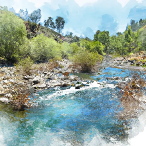
The segment mileage of the Whitewater River Run Section Line to Confluence with Rock Creek is approximately 7 miles. The run features several rapids, including the "Deadman's Drop," "Pinball," and "Shark's Tooth," which offer challenging obstacles for experienced paddlers. The river also features technical sections that require skilled maneuvering, making it a popular destination for kayakers and rafters.
Specific regulations to the area include a permit requirement for all commercial and private groups, and a mandatory safety briefing for all participants. The river is also closed during the winter months due to hazardous conditions caused by snowmelt.
Plan your run down to the hour
Same weather feed Snoflo's iOS app uses -- updated continuously from NOAA / yr.no. Watch the precipitation column on the meteogram; rain ahead of a run typically lifts flows 12-48 hours later depending on the basin.
Next 5 days, hour by hour
Temperature line with weather symbols on top, snow + rain accumulation as columns, humidity as a dotted line.
5-day forecast table
Every 3 hours, broken out across temperature, snow, rain, humidity, and wind. Each cell is colour-coded relative to the column min/max.
| Time | Condition | Temp (°F) | Snow (in) | Rain (in) | Humidity (%) | Wind (mps) | Wind dir |
|---|---|---|---|---|---|---|---|
| Loading detailed forecast… | |||||||
15-day temperature & precipitation
Daily temperatures, snow, and rain projected over the next two weeks -- the upstream story that drives next week's flows.
Regional streamflow levels
USGS streamgauges around Section Line To Confluence With Rock Creek -- useful for spotting upstream pulses and gauging which tributary is contributing what.
| Streamgauge | Discharge | View |
|---|---|---|
| Sespe Creek Near Wheeler Springs Ca | 1 cfs | → |
| Matilija C Nr Res Nr Matilija Hot Springs Ca | 2 cfs | → |
| Santa Paula C Nr Santa Paula | 7 cfs | → |
| Ventura R Nr Ventura | 15 cfs | → |
| Sespe C Nr Fillmore | 13 cfs | → |
| Carpinteria C Nr Carpinteria Ca | · | → |
Plan a longer trip
The closest boat launches, other paddle runs, and campgrounds so a day on the water can grow into a full weekend.
Boat launches
- Lake Casitas Recreation Area (Santa Ana)
- Santa Ana Road Ventura County
- Lake Casitas Recreation Area (West) (Coyote Boat)
Other river runs
- Chorro Grande Canyon To Section Line Dividing Sec 1, T5n, R23w And Sec 6, T5n, T22w
- Headwaters, Upper Piru Creek To Wildernes Boundary
- Wilderness Boundary To Confluence With Gold Hill Creek
- Confluence With Gold Hill Creek To Castaic
- Castaic To Pyramid Reservoir
Campgrounds
- Rose Valley
- Rose Valley Campground
- Middle Lion Campground
- Middle Lion
- Piedra Blanca Camp
- West Fork Lion Camp
Fishing spots
Parks
Whitewater safety
- Check the flow before you run
- Use the linked-gauge card and Regional Flow panel above. Class ratings change with flow -- a Class III at low water can become Class IV+ at high water.
- Know your skill ceiling
- Pick runs comfortably below your ceiling. Cold-water and big-water runs raise the consequences of any mistake.
- Wear the right gear
- Helmet, PFD, drysuit / wetsuit when water is below 60°F. Throw bag, knife, and whistle on your person, not in the boat.
- Scout, set safety, and run with a team
- Scout new rapids on foot, set safety with throw bags above the consequence pool, and run with at least one other competent paddler.
- Respect the river
- Strainers, undercuts, low-head dams, and wood can kill at any class rating. When in doubt, portage.
Set push alerts in the Snoflo app
Save Section Line To Confluence With Rock Creek as a favorite, set a discharge threshold (e.g. "alert me when flow hits 600 cfs"), and the iOS app pushes the moment the linked gauge crosses.
About Section Line To Confluence With Rock Creek
What's the optimal flow for Section Line To Confluence With Rock Creek?
The optimal flow depends on the section and the craft. Check the Run Details panel for the linked gauge and current status.
How fresh is the cfs reading on this page?
The linked USGS streamgauge reports continuously (every 15 minutes); Snoflo refreshes throughout the day. Hover the streamflow sparkline to read individual datapoints.
What's the whitewater class?
See the Run Details panel for the class rating Snoflo tracks for this run. Class ratings change with flow -- a Class III at low water can become Class IV in high water.
Where do I put in / take out?
Tap Directions in the hero above to open driving directions to the put-in. For shuttle planning, check the Nearby Boat Launches panel and the river run operator's site.
Can I get alerts when flows hit the optimal range?
Yes -- alerts are managed in the Snoflo iOS app. Favorite this run, set a discharge threshold, and you'll get a push the moment the gauge crosses.
Other runs near here
Snoflo-tracked paddle runs within driving distance of Section Line To Confluence With Rock Creek.