North Fork Mokelumne River river run
Community Reviews
Been here? Share the conditions.
Reviews, ratings & photos are added in the free Snoflo iOS app — rate a spot, tag the conditions, and your visit is verified by location. Add or manage your reviews from the app.
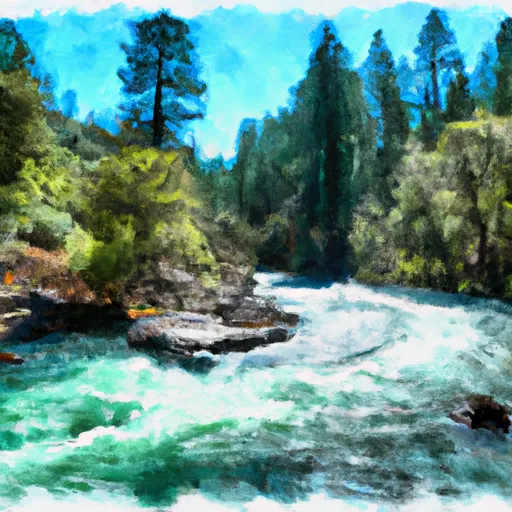
North Fork Mokelumne River
This river is rated as a Class IV-V run, which means it is a challenging and technical run with significant rapids and obstacles. The segment mileage for this river is approximately 9 miles, starting at the powerhouse and ending at the Salt Springs Reservoir.
There are several notable rapids and obstacles on the North Fork Mokelumne River, including Devil's Teeth, which is a Class V rapid with steep drops and tight turns. There is also a portage around a dangerous hydraulic feature known as "The Sieve."
There are specific regulations to the area, including a permit requirement for all boaters and a limit on the number of permits issued per day. Additionally, boaters must follow strict guidelines for camping and waste disposal in order to protect the ecosystem of the river.
Overall, the North Fork Mokelumne River is a challenging and rewarding whitewater run that requires skill and experience to navigate safely. Boaters must be prepared for the technical rapids and obstacles, as well as the specific regulations and permit requirements of the area.
Plan your run down to the hour
Same weather feed Snoflo's iOS app uses -- updated continuously from NOAA / yr.no. Watch the precipitation column on the meteogram; rain ahead of a run typically lifts flows 12-48 hours later depending on the basin.
Next 5 days, hour by hour
Temperature line with weather symbols on top, snow + rain accumulation as columns, humidity as a dotted line.
5-day forecast table
Every 3 hours, broken out across temperature, snow, rain, humidity, and wind. Each cell is colour-coded relative to the column min/max.
| Time | Condition | Temp (°F) | Snow (in) | Rain (in) | Humidity (%) | Wind (mps) | Wind dir |
|---|---|---|---|---|---|---|---|
| Loading detailed forecast… | |||||||
15-day temperature & precipitation
Daily temperatures, snow, and rain projected over the next two weeks -- the upstream story that drives next week's flows.
Regional streamflow levels
USGS streamgauges around North Fork Mokelumne River -- useful for spotting upstream pulses and gauging which tributary is contributing what.
| Streamgauge | Discharge | View |
|---|---|---|
| Cosumnes R A Michigan Bar Ca | 46 cfs | → |
| Deer C Nr Cameron Park Ca | 8 cfs | → |
| Black C Nr Copperopolis Ca | · | → |
| Pilot C Ab Stumpy Meadows Res Ca | 3 cfs | → |
| Pilot C Bl Mutton Canyon Nr Georgetown Ca | 2 cfs | → |
| Upper Truckee R At S Upper Truckee Rd Nr Meyers Ca | 4 cfs | → |
Plan a longer trip
The closest boat launches, other paddle runs, and campgrounds so a day on the water can grow into a full weekend.
Other river runs
Campgrounds
- Indian Grinding Rock State Park
- Indian Grinding Rock Campground
- Jackson Rancheria Rv Park
- Sly Guard Cabin
- Pipi Campground
- Pipi
Fishing spots
Parks
Whitewater safety
- Check the flow before you run
- Use the linked-gauge card and Regional Flow panel above. Class ratings change with flow -- a Class III at low water can become Class IV+ at high water.
- Know your skill ceiling
- Pick runs comfortably below your ceiling. Cold-water and big-water runs raise the consequences of any mistake.
- Wear the right gear
- Helmet, PFD, drysuit / wetsuit when water is below 60°F. Throw bag, knife, and whistle on your person, not in the boat.
- Scout, set safety, and run with a team
- Scout new rapids on foot, set safety with throw bags above the consequence pool, and run with at least one other competent paddler.
- Respect the river
- Strainers, undercuts, low-head dams, and wood can kill at any class rating. When in doubt, portage.
Set push alerts in the Snoflo app
Save North Fork Mokelumne River as a favorite, set a discharge threshold (e.g. "alert me when flow hits 600 cfs"), and the iOS app pushes the moment the linked gauge crosses.
About North Fork Mokelumne River
What's the optimal flow for North Fork Mokelumne River?
The optimal flow depends on the section and the craft. Check the Run Details panel for the linked gauge and current status.
How fresh is the cfs reading on this page?
The linked USGS streamgauge reports continuously (every 15 minutes); Snoflo refreshes throughout the day. Hover the streamflow sparkline to read individual datapoints.
What's the whitewater class?
See the Run Details panel for the class rating Snoflo tracks for this run. Class ratings change with flow -- a Class III at low water can become Class IV in high water.
Where do I put in / take out?
Tap Directions in the hero above to open driving directions to the put-in. For shuttle planning, check the Nearby Boat Launches panel and the river run operator's site.
Can I get alerts when flows hit the optimal range?
Yes -- alerts are managed in the Snoflo iOS app. Favorite this run, set a discharge threshold, and you'll get a push the moment the gauge crosses.
Other runs near here
Snoflo-tracked paddle runs within driving distance of North Fork Mokelumne River.