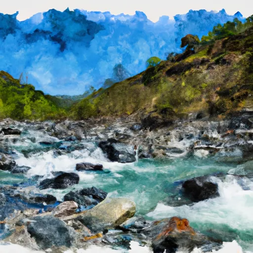
North Fork Cache Creek river run
Community Reviews
Been here? Share the conditions.
Reviews, ratings & photos are added in the free Snoflo iOS app — rate a spot, tag the conditions, and your visit is verified by location. Add or manage your reviews from the app.
North Fork Cache Creek
The segment mileage for the North Fork Cache Creek is approximately 12 miles, starting at the North Fork Campground and ending at the confluence with the Middle Fork Cache Creek. The river is known for its challenging rapids, including the infamous "Mother" and "Son of Mother" rapids. Other notable rapids include Carnivore, Pearly Gates, and Hell's Half Acre.
There are specific regulations that apply to the North Fork Cache Creek area. All boaters must obtain a permit from the Bureau of Land Management before launching on the river. Additionally, the use of alcohol and drugs is prohibited on the river. It is also important to note that the river flows through private land, so boaters must stay within the river channel and avoid trespassing.
Overall, the North Fork Cache Creek is a thrilling and challenging whitewater river run that requires skill and experience to navigate safely. Boaters must be aware of the ideal streamflow range, class rating, and specific regulations to ensure a successful and enjoyable trip.
Plan your run down to the hour
Same weather feed Snoflo's iOS app uses -- updated continuously from NOAA / yr.no. Watch the precipitation column on the meteogram; rain ahead of a run typically lifts flows 12-48 hours later depending on the basin.
Next 5 days, hour by hour
Temperature line with weather symbols on top, snow + rain accumulation as columns, humidity as a dotted line.
5-day forecast table
Every 3 hours, broken out across temperature, snow, rain, humidity, and wind. Each cell is colour-coded relative to the column min/max.
| Time | Condition | Temp (°F) | Snow (in) | Rain (in) | Humidity (%) | Wind (mps) | Wind dir |
|---|---|---|---|---|---|---|---|
| Loading detailed forecast… | |||||||
15-day temperature & precipitation
Daily temperatures, snow, and rain projected over the next two weeks -- the upstream story that drives next week's flows.
Regional streamflow levels
USGS streamgauges around North Fork Cache Creek -- useful for spotting upstream pulses and gauging which tributary is contributing what.
| Streamgauge | Discharge | View |
|---|---|---|
| Nf Cache C A Hough Spring Nr Clearlake Oaks Ca | 31 cfs | → |
| Nf Cache C Nr Clearlake Oaks Ca | 263 cfs | → |
| Cache C Nr Lower Lake Ca | 505 cfs | → |
| Kelsey C Nr Kelseyville Ca | 4 cfs | → |
| Bear C Ab Holsten Chimney Cyn Nr Rumsey Ca | 20 cfs | → |
| Ef Russian R Nr Calpella Ca | 29 cfs | → |
Plan a longer trip
The closest boat launches, other paddle runs, and campgrounds so a day on the water can grow into a full weekend.
Boat launches
- Lucerne Harbor County Park
- Lucerne Harbor Park
- Tally's Family Resort
- H.V. Keeling County Park
- Walker Ridge Road Lake County
- Blue Fish Cove Resort
Other river runs
- Headwaters In Sec 28, T18n, R8w To One-Third Mile Beyond Snow Mt. Wilderness Boundary At Private Property Boundary Near Paradise Creek
- Cache Creek
Campgrounds
Fishing spots
Parks
- Mendocino National Forest
- Lucerne Alpine Park
- Nice Keeling Park
- Lakeside Park
- Clear Lake State Park
- Austin Park
Points of interest
Whitewater safety
- Check the flow before you run
- Use the linked-gauge card and Regional Flow panel above. Class ratings change with flow -- a Class III at low water can become Class IV+ at high water.
- Know your skill ceiling
- Pick runs comfortably below your ceiling. Cold-water and big-water runs raise the consequences of any mistake.
- Wear the right gear
- Helmet, PFD, drysuit / wetsuit when water is below 60°F. Throw bag, knife, and whistle on your person, not in the boat.
- Scout, set safety, and run with a team
- Scout new rapids on foot, set safety with throw bags above the consequence pool, and run with at least one other competent paddler.
- Respect the river
- Strainers, undercuts, low-head dams, and wood can kill at any class rating. When in doubt, portage.
Set push alerts in the Snoflo app
Save North Fork Cache Creek as a favorite, set a discharge threshold (e.g. "alert me when flow hits 600 cfs"), and the iOS app pushes the moment the linked gauge crosses.
About North Fork Cache Creek
What's the optimal flow for North Fork Cache Creek?
The optimal flow depends on the section and the craft. Check the Run Details panel for the linked gauge and current status.
How fresh is the cfs reading on this page?
The linked USGS streamgauge reports continuously (every 15 minutes); Snoflo refreshes throughout the day. Hover the streamflow sparkline to read individual datapoints.
What's the whitewater class?
See the Run Details panel for the class rating Snoflo tracks for this run. Class ratings change with flow -- a Class III at low water can become Class IV in high water.
Where do I put in / take out?
Tap Directions in the hero above to open driving directions to the put-in. For shuttle planning, check the Nearby Boat Launches panel and the river run operator's site.
Can I get alerts when flows hit the optimal range?
Yes -- alerts are managed in the Snoflo iOS app. Favorite this run, set a discharge threshold, and you'll get a push the moment the gauge crosses.
Other runs near here
Snoflo-tracked paddle runs within driving distance of North Fork Cache Creek.