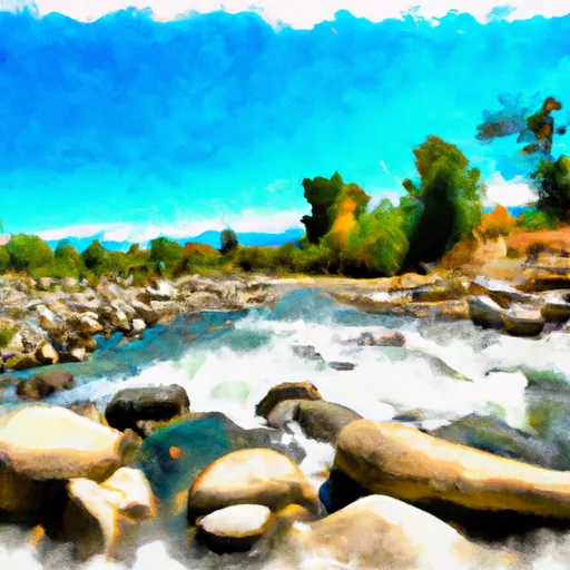
Fish Creek river run
Fish Creek
The segment mileage of Fish Creek is approximately 6 miles, and includes a series of challenging rapids and obstacles, including Class V drops, narrow chutes, and tight turns. Some of the most notable rapids on this run include the Chamberlain Falls, the Toilet Bowl, and the Leap of Faith.
In addition to its challenging rapids, Fish Creek is also known for its stunning scenery and natural beauty. Paddlers can enjoy breathtaking views of the surrounding mountains and forests as they navigate the river.
There are specific regulations in place for this area, including a requirement for helmets and personal flotation devices for all paddlers, as well as restrictions on camping and fires in certain areas. It is important for paddlers to familiarize themselves with these regulations before embarking on their river run.
Overall, Fish Creek is a thrilling and challenging whitewater river run that is popular among experienced paddlers in California. Its high-intensity rapids and stunning scenery make it a must-see destination for anyone looking for an exciting outdoor adventure.
Plan your run down to the hour
Same weather feed Snoflo's iOS app uses -- updated continuously from NOAA / yr.no. Watch the precipitation column on the meteogram; rain ahead of a run typically lifts flows 12-48 hours later depending on the basin.
Next 5 days, hour by hour
Temperature line with weather symbols on top, snow + rain accumulation as columns, humidity as a dotted line.
5-day forecast table
Every 3 hours, broken out across temperature, snow, rain, humidity, and wind. Each cell is colour-coded relative to the column min/max.
| Time | Condition | Temp (°F) | Snow (in) | Rain (in) | Humidity (%) | Wind (mps) | Wind dir |
|---|---|---|---|---|---|---|---|
| Loading detailed forecast… | |||||||
15-day temperature & precipitation
Daily temperatures, snow, and rain projected over the next two weeks -- the upstream story that drives next week's flows.
Regional streamflow levels
USGS streamgauges around Fish Creek -- useful for spotting upstream pulses and gauging which tributary is contributing what.
| Streamgauge | Discharge | View |
|---|---|---|
| Mf Eel R Nr Dos Rios Ca | 310 cfs | → |
| Outlet C Nr Willits Ca | 4 cfs | → |
| Willits C Ab Lk Emily Nr Willits Ca | 0 cfs | → |
| Ef Russian R Nr Calpella Ca | 42 cfs | → |
| Elder C Nr Branscomb Ca | 5 cfs | → |
| Ef Russian R Nr Ukiah Ca | 156 cfs | → |
Plan a longer trip
The closest boat launches, other paddle runs, and campgrounds so a day on the water can grow into a full weekend.
Other river runs
Campgrounds
- Creekside Cabins
- Sleepy Hollow Rv Park
- Bear Flats
- Grizzly Flat Dispersed Camping
- Trout Creek Campgounds
- Pogie Point Campground
Fishing spots
Whitewater safety
- Check the flow before you run
- Use the linked-gauge card and Regional Flow panel above. Class ratings change with flow -- a Class III at low water can become Class IV+ at high water.
- Know your skill ceiling
- Pick runs comfortably below your ceiling. Cold-water and big-water runs raise the consequences of any mistake.
- Wear the right gear
- Helmet, PFD, drysuit / wetsuit when water is below 60°F. Throw bag, knife, and whistle on your person, not in the boat.
- Scout, set safety, and run with a team
- Scout new rapids on foot, set safety with throw bags above the consequence pool, and run with at least one other competent paddler.
- Respect the river
- Strainers, undercuts, low-head dams, and wood can kill at any class rating. When in doubt, portage.
Set push alerts in the Snoflo app
Save Fish Creek as a favorite, set a discharge threshold (e.g. "alert me when flow hits 600 cfs"), and the iOS app pushes the moment the linked gauge crosses.
About Fish Creek
What's the optimal flow for Fish Creek?
The optimal flow depends on the section and the craft. Check the Run Details panel for the linked gauge and current status.
How fresh is the cfs reading on this page?
The linked USGS streamgauge reports continuously (every 15 minutes); Snoflo refreshes throughout the day. Hover the streamflow sparkline to read individual datapoints.
What's the whitewater class?
See the Run Details panel for the class rating Snoflo tracks for this run. Class ratings change with flow -- a Class III at low water can become Class IV in high water.
Where do I put in / take out?
Tap Directions in the hero above to open driving directions to the put-in. For shuttle planning, check the Nearby Boat Launches panel and the river run operator's site.
Can I get alerts when flows hit the optimal range?
Yes -- alerts are managed in the Snoflo iOS app. Favorite this run, set a discharge threshold, and you'll get a push the moment the gauge crosses.
Other runs near here
Snoflo-tracked paddle runs within driving distance of Fish Creek.