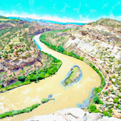
Eastern Boundary Of Dinosaur National Monument To Confluence With Green River River Run
Community Reviews
Been here? Share the conditions.
Reviews, ratings & photos are added in the free Snoflo iOS app — rate a spot, tag the conditions, and your visit is verified by location. Add or manage your reviews from the app.
Eastern Boundary Of Dinosaur National Monument To Confluence With Green River
This section of the river is known for its challenging rapids, including Warm Springs Rapid, Skull Rapid, and Teepee Rapid. These rapids have steep drops, sharp turns, and large waves, which require precise navigation. Additionally, there are several obstacles along the river, including rocks, boulders, and strainers, which require constant attention.
Due to the rugged terrain and remote location, there are specific regulations for paddling on this section of the river. A permit is required to access the river, and all visitors must adhere to the Leave No Trace principles. Additionally, all boaters must be equipped with proper safety equipment, including a personal flotation device, helmet, and whistle.
In conclusion, the whitewater river run from the Eastern Boundary of Dinosaur National Monument to the confluence with Green River in Colorado is a challenging and rewarding experience for experienced paddlers. The ideal streamflow range is between 1,000 and 15,000 cfs, with a class III-IV+ rating. Visitors must adhere to specific regulations and safety measures to ensure a safe and enjoyable trip.
Plan your run down to the hour
Same weather feed Snoflo's iOS app uses -- updated continuously from NOAA / yr.no. Watch the precipitation column on the meteogram; rain ahead of a run typically lifts flows 12-48 hours later depending on the basin.
Next 5 days, hour by hour
Temperature line with weather symbols on top, snow + rain accumulation as columns, humidity as a dotted line.
5-day forecast table
Every 3 hours, broken out across temperature, snow, rain, humidity, and wind. Each cell is colour-coded relative to the column min/max.
| Time | Condition | Temp (°F) | Snow (in) | Rain (in) | Humidity (%) | Wind (mps) | Wind dir |
|---|---|---|---|---|---|---|---|
| Loading detailed forecast… | |||||||
15-day temperature & precipitation
Daily temperatures, snow, and rain projected over the next two weeks -- the upstream story that drives next week's flows.
Regional streamflow levels
USGS streamgauges around Eastern Boundary Of Dinosaur National Monument To Confluence With Green River -- useful for spotting upstream pulses and gauging which tributary is contributing what.
| Streamgauge | Discharge | View |
|---|---|---|
| Yampa River At Deerlodge Park | 48 cfs | → |
| Little Snake River Near Lily | 0 cfs | → |
| White River Below Boise Creek | 88 cfs | → |
| Yellow Creek Near White River | 0 cfs | → |
| White R Ab Crooked Wash Nr White River City | 1,510 cfs | → |
| Yampa River Near Maybell | 65 cfs | → |
Plan a longer trip
The closest boat launches, other paddle runs, and campgrounds so a day on the water can grow into a full weekend.
Other river runs
- Yampa Canyon
- Yampa River Segment 3
- Cross Mountain Gorge
- Whirlpool Canyon - Echo Park To Rainbow Park
- Gates Of Lodore To The Southern Boundary Of Dinosaur National Monument, South Of The Split Mountain Boat Landing
Whitewater safety
- Check the flow before you run
- Use the linked-gauge card and Regional Flow panel above. Class ratings change with flow -- a Class III at low water can become Class IV+ at high water.
- Know your skill ceiling
- Pick runs comfortably below your ceiling. Cold-water and big-water runs raise the consequences of any mistake.
- Wear the right gear
- Helmet, PFD, drysuit / wetsuit when water is below 60°F. Throw bag, knife, and whistle on your person, not in the boat.
- Scout, set safety, and run with a team
- Scout new rapids on foot, set safety with throw bags above the consequence pool, and run with at least one other competent paddler.
- Respect the river
- Strainers, undercuts, low-head dams, and wood can kill at any class rating. When in doubt, portage.
Set push alerts in the Snoflo app
Save Eastern Boundary Of Dinosaur National Monument To Confluence With Green River as a favorite, set a discharge threshold (e.g. "alert me when flow hits 600 cfs"), and the iOS app pushes the moment the linked gauge crosses.
About Eastern Boundary Of Dinosaur National Monument To Confluence With Green River
What's the optimal flow for Eastern Boundary Of Dinosaur National Monument To Confluence With Green River?
The optimal flow depends on the section and the craft. Check the Run Details panel for the linked gauge and current status.
How fresh is the cfs reading on this page?
The linked USGS streamgauge reports continuously (every 15 minutes); Snoflo refreshes throughout the day. Hover the streamflow sparkline to read individual datapoints.
What's the whitewater class?
See the Run Details panel for the class rating Snoflo tracks for this run. Class ratings change with flow -- a Class III at low water can become Class IV in high water.
Where do I put in / take out?
Tap Directions in the hero above to open driving directions to the put-in. For shuttle planning, check the Nearby Boat Launches panel and the river run operator's site.
Can I get alerts when flows hit the optimal range?
Yes -- alerts are managed in the Snoflo iOS app. Favorite this run, set a discharge threshold, and you'll get a push the moment the gauge crosses.
Other runs near here
Snoflo-tracked paddle runs within driving distance of Eastern Boundary Of Dinosaur National Monument To Confluence With Green River.