Yampa River Segment 3 River Run
Community Reviews
Been here? Share the conditions.
Reviews, ratings & photos are added in the free Snoflo iOS app — rate a spot, tag the conditions, and your visit is verified by location. Add or manage your reviews from the app.
Yampa River Segment 3
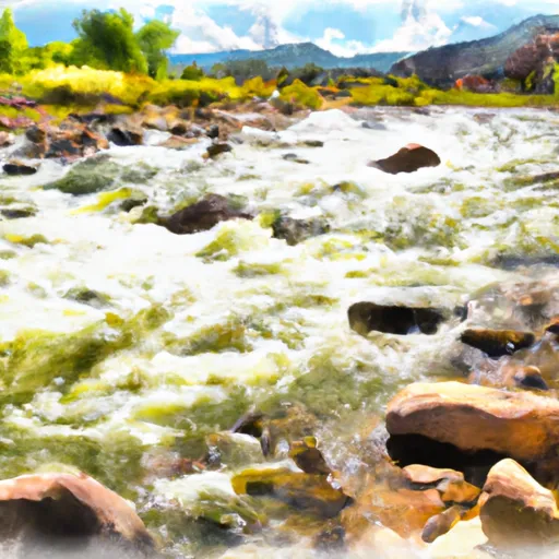
There are several notable rapids and obstacles on this section, including Warm Springs Rapid, Teepee Rapid, and Big Joe Rapid. Warm Springs Rapid is a class IV rapid that requires technical maneuvering around large rocks and a sharp right-hand turn. Teepee Rapid is another class IV rapid with a steep drop and large waves. Big Joe Rapid is a class III rapid with large waves and a narrow channel.
In terms of regulations, this section of the Yampa River is managed by the Bureau of Land Management and has specific guidelines for camping and fire use. Campsites must be established in designated areas only, and campfires are only permitted in established fire rings. Additionally, all visitors are required to have a valid river permit and to follow minimum impact practices to protect the natural resources of the area.
Overall, Yampa River Segment 3 offers a thrilling whitewater experience for intermediate to advanced paddlers with its technical rapids and beautiful scenery. It is important for visitors to follow the regulations and guidelines set in place to preserve the natural resources of the area.
Plan your run down to the hour
Same weather feed Snoflo's iOS app uses -- updated continuously from NOAA / yr.no. Watch the precipitation column on the meteogram; rain ahead of a run typically lifts flows 12-48 hours later depending on the basin.
Next 5 days, hour by hour
Temperature line with weather symbols on top, snow + rain accumulation as columns, humidity as a dotted line.
5-day forecast table
Every 3 hours, broken out across temperature, snow, rain, humidity, and wind. Each cell is colour-coded relative to the column min/max.
| Time | Condition | Temp (°F) | Snow (in) | Rain (in) | Humidity (%) | Wind (mps) | Wind dir |
|---|---|---|---|---|---|---|---|
| Loading detailed forecast… | |||||||
15-day temperature & precipitation
Daily temperatures, snow, and rain projected over the next two weeks -- the upstream story that drives next week's flows.
Regional streamflow levels
USGS streamgauges around Yampa River Segment 3 -- useful for spotting upstream pulses and gauging which tributary is contributing what.
| Streamgauge | Discharge | View |
|---|---|---|
| Little Snake River Near Lily | 0 cfs | → |
| Yampa River At Deerlodge Park | 48 cfs | → |
| Yampa River Near Maybell | 65 cfs | → |
| Yellow Creek Near White River | 0 cfs | → |
| White R Ab Crooked Wash Nr White River City | 1,510 cfs | → |
| White River Below Boise Creek | 88 cfs | → |
Plan a longer trip
The closest boat launches, other paddle runs, and campgrounds so a day on the water can grow into a full weekend.
Other river runs
- Cross Mountain Gorge
- Eastern Boundary Of Dinosaur National Monument To Confluence With Green River
- Yampa Canyon
- Yampa River Segment 2
- Gates Of Lodore To The Southern Boundary Of Dinosaur National Monument, South Of The Split Mountain Boat Landing
Whitewater safety
- Check the flow before you run
- Use the linked-gauge card and Regional Flow panel above. Class ratings change with flow -- a Class III at low water can become Class IV+ at high water.
- Know your skill ceiling
- Pick runs comfortably below your ceiling. Cold-water and big-water runs raise the consequences of any mistake.
- Wear the right gear
- Helmet, PFD, drysuit / wetsuit when water is below 60°F. Throw bag, knife, and whistle on your person, not in the boat.
- Scout, set safety, and run with a team
- Scout new rapids on foot, set safety with throw bags above the consequence pool, and run with at least one other competent paddler.
- Respect the river
- Strainers, undercuts, low-head dams, and wood can kill at any class rating. When in doubt, portage.
Set push alerts in the Snoflo app
Save Yampa River Segment 3 as a favorite, set a discharge threshold (e.g. "alert me when flow hits 600 cfs"), and the iOS app pushes the moment the linked gauge crosses.
About Yampa River Segment 3
What's the optimal flow for Yampa River Segment 3?
The optimal flow depends on the section and the craft. Check the Run Details panel for the linked gauge and current status.
How fresh is the cfs reading on this page?
The linked USGS streamgauge reports continuously (every 15 minutes); Snoflo refreshes throughout the day. Hover the streamflow sparkline to read individual datapoints.
What's the whitewater class?
See the Run Details panel for the class rating Snoflo tracks for this run. Class ratings change with flow -- a Class III at low water can become Class IV in high water.
Where do I put in / take out?
Tap Directions in the hero above to open driving directions to the put-in. For shuttle planning, check the Nearby Boat Launches panel and the river run operator's site.
Can I get alerts when flows hit the optimal range?
Yes -- alerts are managed in the Snoflo iOS app. Favorite this run, set a discharge threshold, and you'll get a push the moment the gauge crosses.
Other runs near here
Snoflo-tracked paddle runs within driving distance of Yampa River Segment 3.