Sec 10, T42n, R1e To Sec 13, T41n, R1e River Run
Community Reviews
Been here? Share the conditions.
Reviews, ratings & photos are added in the free Snoflo iOS app — rate a spot, tag the conditions, and your visit is verified by location. Add or manage your reviews from the app.
Sec 10, T42n, R1e To Sec 13, T41n, R1e
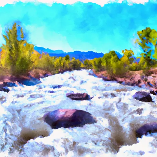
This section of the river is rated as Class III-IV, making it suitable for intermediate to advanced paddlers. The segment mileage for this run is approximately 6.5 miles, with several notable rapids including Zoom Flume, Plunge, and Pinball.
As with any whitewater run, it is important to be aware of any obstacles or hazards. In addition to the rapids, this section of the river has several large boulders and tight turns that require careful navigation.
There are also specific regulations to the area that paddlers should be aware of. Permits are required for commercial outfitters, and all paddlers are required to wear personal flotation devices and helmets. Camping is only allowed in designated areas, and fires are prohibited.
Plan your run down to the hour
Same weather feed Snoflo's iOS app uses -- updated continuously from NOAA / yr.no. Watch the precipitation column on the meteogram; rain ahead of a run typically lifts flows 12-48 hours later depending on the basin.
Next 5 days, hour by hour
Temperature line with weather symbols on top, snow + rain accumulation as columns, humidity as a dotted line.
5-day forecast table
Every 3 hours, broken out across temperature, snow, rain, humidity, and wind. Each cell is colour-coded relative to the column min/max.
| Time | Condition | Temp (°F) | Snow (in) | Rain (in) | Humidity (%) | Wind (mps) | Wind dir |
|---|---|---|---|---|---|---|---|
| Loading detailed forecast… | |||||||
15-day temperature & precipitation
Daily temperatures, snow, and rain projected over the next two weeks -- the upstream story that drives next week's flows.
Regional streamflow levels
USGS streamgauges around Sec 10, T42n, R1e To Sec 13, T41n, R1e -- useful for spotting upstream pulses and gauging which tributary is contributing what.
| Streamgauge | Discharge | View |
|---|---|---|
| Rio Grande At Wagon Wheel Gap | 167 cfs | → |
| Goose Creek At Wagonwheel Gap | 13 cfs | → |
| South Fork Rio Grande At South Fork | 45 cfs | → |
| North Clear Creek Bl Continental Reservoir | 6 cfs | → |
| Rio Grande Near Del Norte | 215 cfs | → |
| Rio Grande At Thirtymile Bridge | 81 cfs | → |
Plan a longer trip
The closest boat launches, other paddle runs, and campgrounds so a day on the water can grow into a full weekend.
Boat launches
- Creede State Wildlife Area
- Coller State Wildlife Area
- Deer Park Fishing Access
- Beaver Creek Reservoir State Wildlife Area
Other river runs
- Sec 30, T41n, R2e To Sec 11, T40n, R2e
- Below Big Meadows Reservoir Dam To Sec 9 And 10, T39n, R3e
- Below Rio Grande Reservoir (Sec 13, T40n, R4w) To Spring Creek (Sec 31, T41n, R2w)
- Headwaters (Sec 21, T38n, R1e) To 1/4 Mile Above Big Meadows Reservoir
- Confluence Of North, Middle And South Forks (Sec 4, T43n, R3e) To Nf Boundary (Sec 17, T44n, R4e)
Campgrounds
- Wheeler Basin Site 2
- Wheeler Baisin Site 3
- Blue Creek Lodge & Rv Park
- Hansons Mill Dispersed Camping
- Hansons Mill
- Palisade - South Fork
Whitewater safety
- Check the flow before you run
- Use the linked-gauge card and Regional Flow panel above. Class ratings change with flow -- a Class III at low water can become Class IV+ at high water.
- Know your skill ceiling
- Pick runs comfortably below your ceiling. Cold-water and big-water runs raise the consequences of any mistake.
- Wear the right gear
- Helmet, PFD, drysuit / wetsuit when water is below 60°F. Throw bag, knife, and whistle on your person, not in the boat.
- Scout, set safety, and run with a team
- Scout new rapids on foot, set safety with throw bags above the consequence pool, and run with at least one other competent paddler.
- Respect the river
- Strainers, undercuts, low-head dams, and wood can kill at any class rating. When in doubt, portage.
Set push alerts in the Snoflo app
Save Sec 10, T42n, R1e To Sec 13, T41n, R1e as a favorite, set a discharge threshold (e.g. "alert me when flow hits 600 cfs"), and the iOS app pushes the moment the linked gauge crosses.
About Sec 10, T42n, R1e To Sec 13, T41n, R1e
What's the optimal flow for Sec 10, T42n, R1e To Sec 13, T41n, R1e?
The optimal flow depends on the section and the craft. Check the Run Details panel for the linked gauge and current status.
How fresh is the cfs reading on this page?
The linked USGS streamgauge reports continuously (every 15 minutes); Snoflo refreshes throughout the day. Hover the streamflow sparkline to read individual datapoints.
What's the whitewater class?
See the Run Details panel for the class rating Snoflo tracks for this run. Class ratings change with flow -- a Class III at low water can become Class IV in high water.
Where do I put in / take out?
Tap Directions in the hero above to open driving directions to the put-in. For shuttle planning, check the Nearby Boat Launches panel and the river run operator's site.
Can I get alerts when flows hit the optimal range?
Yes -- alerts are managed in the Snoflo iOS app. Favorite this run, set a discharge threshold, and you'll get a push the moment the gauge crosses.
Other runs near here
Snoflo-tracked paddle runs within driving distance of Sec 10, T42n, R1e To Sec 13, T41n, R1e.