Sec 30, T41n, R2e To Sec 11, T40n, R2e River Run
Community Reviews
Been here? Share the conditions.
Reviews, ratings & photos are added in the free Snoflo iOS app — rate a spot, tag the conditions, and your visit is verified by location. Add or manage your reviews from the app.
Sec 30, T41n, R2e To Sec 11, T40n, R2e
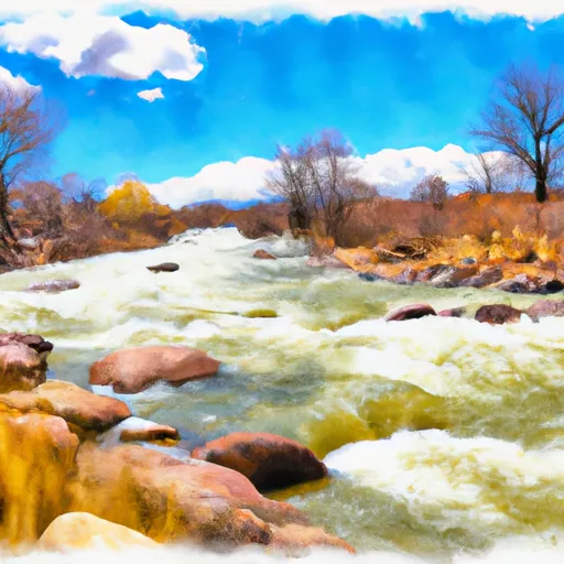
The segment is rated as Class III-IV and features several challenging rapids and obstacles, including Dead Deer, Pinball, and Toilet Bowl. Dead Deer is a rapid that requires precise maneuvering to navigate through the narrow chutes. Pinball features a series of boulders and drops that require quick reflexes and sharp turns. Toilet Bowl is a large whirlpool that can be difficult to navigate.
There are specific regulations to be followed in this area, including the use of personal flotation devices (PFDs) and helmets while on the river. The use of alcohol and drugs is prohibited, and visitors are advised to follow leave no trace principles to minimize their impact on the environment.
In conclusion, the Whitewater River Run in Colorado offers an exciting and challenging experience to whitewater enthusiasts. The ideal streamflow range is between 800 and 2,000 cfs, and the segment covers a distance of approximately 15 miles. The river is rated as Class III-IV and features several challenging rapids and obstacles. Visitors are advised to follow specific regulations, including the use of PFDs and helmets, prohibition of alcohol and drugs, and leave no trace principles.
Plan your run down to the hour
Same weather feed Snoflo's iOS app uses -- updated continuously from NOAA / yr.no. Watch the precipitation column on the meteogram; rain ahead of a run typically lifts flows 12-48 hours later depending on the basin.
Next 5 days, hour by hour
Temperature line with weather symbols on top, snow + rain accumulation as columns, humidity as a dotted line.
5-day forecast table
Every 3 hours, broken out across temperature, snow, rain, humidity, and wind. Each cell is colour-coded relative to the column min/max.
| Time | Condition | Temp (°F) | Snow (in) | Rain (in) | Humidity (%) | Wind (mps) | Wind dir |
|---|---|---|---|---|---|---|---|
| Loading detailed forecast… | |||||||
15-day temperature & precipitation
Daily temperatures, snow, and rain projected over the next two weeks -- the upstream story that drives next week's flows.
Regional streamflow levels
USGS streamgauges around Sec 30, T41n, R2e To Sec 11, T40n, R2e -- useful for spotting upstream pulses and gauging which tributary is contributing what.
| Streamgauge | Discharge | View |
|---|---|---|
| South Fork Rio Grande At South Fork | 59 cfs | → |
| Goose Creek At Wagonwheel Gap | 10 cfs | → |
| Rio Grande At Wagon Wheel Gap | 182 cfs | → |
| Rio Grande Near Del Norte | 243 cfs | → |
| Pinos Creek Near Del Norte | 5 cfs | → |
| San Francisco C At Upper Sta | 1 cfs | → |
Plan a longer trip
The closest boat launches, other paddle runs, and campgrounds so a day on the water can grow into a full weekend.
Boat launches
- Coller State Wildlife Area
- Deer Park Fishing Access
- Beaver Creek Reservoir State Wildlife Area
- Rio Grande River State Wildlife Area (Del Norte Fishing Easements)
Other river runs
- Below Big Meadows Reservoir Dam To Sec 9 And 10, T39n, R3e
- Sec 10, T42n, R1e To Sec 13, T41n, R1e
- Headwaters (Sec 21, T38n, R1e) To 1/4 Mile Above Big Meadows Reservoir
- Below Rio Grande Reservoir (Sec 13, T40n, R4w) To Spring Creek (Sec 31, T41n, R2w)
- East Fork--Unnamed Ponds Approx 1/4 Mile Below Continental Divide To Weminuche Wilderness Boundary
Campgrounds
- Alder Guard Station
- Palisade Campground
- Palisade - South Fork
- Highway Springs Campground
- Highway Springs
- Blue Creek Lodge & Rv Park
Whitewater safety
- Check the flow before you run
- Use the linked-gauge card and Regional Flow panel above. Class ratings change with flow -- a Class III at low water can become Class IV+ at high water.
- Know your skill ceiling
- Pick runs comfortably below your ceiling. Cold-water and big-water runs raise the consequences of any mistake.
- Wear the right gear
- Helmet, PFD, drysuit / wetsuit when water is below 60°F. Throw bag, knife, and whistle on your person, not in the boat.
- Scout, set safety, and run with a team
- Scout new rapids on foot, set safety with throw bags above the consequence pool, and run with at least one other competent paddler.
- Respect the river
- Strainers, undercuts, low-head dams, and wood can kill at any class rating. When in doubt, portage.
Set push alerts in the Snoflo app
Save Sec 30, T41n, R2e To Sec 11, T40n, R2e as a favorite, set a discharge threshold (e.g. "alert me when flow hits 600 cfs"), and the iOS app pushes the moment the linked gauge crosses.
About Sec 30, T41n, R2e To Sec 11, T40n, R2e
What's the optimal flow for Sec 30, T41n, R2e To Sec 11, T40n, R2e?
The optimal flow depends on the section and the craft. Check the Run Details panel for the linked gauge and current status.
How fresh is the cfs reading on this page?
The linked USGS streamgauge reports continuously (every 15 minutes); Snoflo refreshes throughout the day. Hover the streamflow sparkline to read individual datapoints.
What's the whitewater class?
See the Run Details panel for the class rating Snoflo tracks for this run. Class ratings change with flow -- a Class III at low water can become Class IV in high water.
Where do I put in / take out?
Tap Directions in the hero above to open driving directions to the put-in. For shuttle planning, check the Nearby Boat Launches panel and the river run operator's site.
Can I get alerts when flows hit the optimal range?
Yes -- alerts are managed in the Snoflo iOS app. Favorite this run, set a discharge threshold, and you'll get a push the moment the gauge crosses.
Other runs near here
Snoflo-tracked paddle runs within driving distance of Sec 30, T41n, R2e To Sec 11, T40n, R2e.