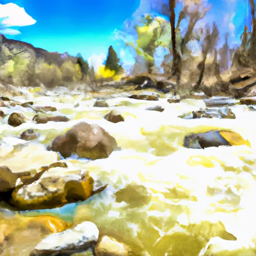
Pass Creek river run
Community Reviews
Been here? Share the conditions.
Reviews, ratings & photos are added in the free Snoflo iOS app — rate a spot, tag the conditions, and your visit is verified by location. Add or manage your reviews from the app.
Pass Creek
Pass Creek has a class III-IV rating, which means that it is suitable for experienced paddlers who have good technical skills and can handle difficult rapids. The segment mileage for Pass Creek is 5.3 miles, providing paddlers with a thrilling and challenging ride.
There are several specific river rapids and obstacles that paddlers should be aware of when navigating Pass Creek. These include the Big Drop, The Maze, and The Squeeze. The Big Drop is a challenging rapid that requires paddlers to navigate a steep drop and avoid rocks and boulders. The Maze is a series of tight turns and drops that require good technical skills and quick reflexes. The Squeeze is a narrow passage that can be challenging to navigate.
To ensure the safety of paddlers and protect the environment, there are several regulations in place for Pass Creek. Paddlers are required to wear a personal flotation device and a helmet at all times while on the river. They are also prohibited from littering and must follow Leave No Trace principles. Additionally, there are restrictions on the use of motorized boats on Pass Creek.
Overall, Pass Creek is a challenging and exciting whitewater river run that requires skill and experience to navigate safely. Paddlers should be aware of the specific rapids and obstacles on the river and follow all regulations to ensure a safe and enjoyable experience.
Plan your run down to the hour
Same weather feed Snoflo's iOS app uses -- updated continuously from NOAA / yr.no. Watch the precipitation column on the meteogram; rain ahead of a run typically lifts flows 12-48 hours later depending on the basin.
Next 5 days, hour by hour
Temperature line with weather symbols on top, snow + rain accumulation as columns, humidity as a dotted line.
5-day forecast table
Every 3 hours, broken out across temperature, snow, rain, humidity, and wind. Each cell is colour-coded relative to the column min/max.
| Time | Condition | Temp (°F) | Snow (in) | Rain (in) | Humidity (%) | Wind (mps) | Wind dir |
|---|---|---|---|---|---|---|---|
| Loading detailed forecast… | |||||||
15-day temperature & precipitation
Daily temperatures, snow, and rain projected over the next two weeks -- the upstream story that drives next week's flows.
Regional streamflow levels
USGS streamgauges around Pass Creek -- useful for spotting upstream pulses and gauging which tributary is contributing what.
| Streamgauge | Discharge | View |
|---|---|---|
| Arkansas River At Salida | 196 cfs | → |
| Arkansas River Near Wellsville | 215 cfs | → |
| Arkansas River Near Nathrop | 191 cfs | → |
| Tomichi Creek At Sargents | 13 cfs | → |
| Kerber Cr Abv Little Kerber Cr Nr Villa Grove | 1 cfs | → |
| Saguache Creek Near Saguache | 12 cfs | → |
Plan a longer trip
The closest boat launches, other paddle runs, and campgrounds so a day on the water can grow into a full weekend.
Boat launches
- Ahra - Big Bend Rec Site
- Road 191 Chaffee County
- Ahra - Stone Bridge Rec Site
- Arkansas Headwaters Recreation Area
- Ahra - Salida East Rec Site
- Ahra - Hecla Junction Rec Site
Other river runs
- Salida Town Run (Stone Bridge To Salida Ww Park)
- Salida Whitewater Park
- Salida To Rincon
- Arkansas River Segment 3
- Browns Canyon (Fisherman's Bridge To Stone Bridge)
Campgrounds
- Koa Camping Salida
- Ohaver Lake
- O'Haver Lake Campground
- Angel Of Shavano
- Angel Of Shavano Campground
- Garfield
Whitewater safety
- Check the flow before you run
- Use the linked-gauge card and Regional Flow panel above. Class ratings change with flow -- a Class III at low water can become Class IV+ at high water.
- Know your skill ceiling
- Pick runs comfortably below your ceiling. Cold-water and big-water runs raise the consequences of any mistake.
- Wear the right gear
- Helmet, PFD, drysuit / wetsuit when water is below 60°F. Throw bag, knife, and whistle on your person, not in the boat.
- Scout, set safety, and run with a team
- Scout new rapids on foot, set safety with throw bags above the consequence pool, and run with at least one other competent paddler.
- Respect the river
- Strainers, undercuts, low-head dams, and wood can kill at any class rating. When in doubt, portage.
Set push alerts in the Snoflo app
Save Pass Creek as a favorite, set a discharge threshold (e.g. "alert me when flow hits 600 cfs"), and the iOS app pushes the moment the linked gauge crosses.
About Pass Creek
What's the optimal flow for Pass Creek?
The optimal flow depends on the section and the craft. Check the Run Details panel for the linked gauge and current status.
How fresh is the cfs reading on this page?
The linked USGS streamgauge reports continuously (every 15 minutes); Snoflo refreshes throughout the day. Hover the streamflow sparkline to read individual datapoints.
What's the whitewater class?
See the Run Details panel for the class rating Snoflo tracks for this run. Class ratings change with flow -- a Class III at low water can become Class IV in high water.
Where do I put in / take out?
Tap Directions in the hero above to open driving directions to the put-in. For shuttle planning, check the Nearby Boat Launches panel and the river run operator's site.
Can I get alerts when flows hit the optimal range?
Yes -- alerts are managed in the Snoflo iOS app. Favorite this run, set a discharge threshold, and you'll get a push the moment the gauge crosses.
Other runs near here
Snoflo-tracked paddle runs within driving distance of Pass Creek.