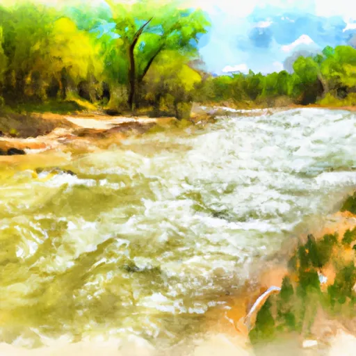
Grape Creek Segment 2 river run
Grape Creek Segment 2
The Grape Creek Segment 2 is a popular whitewater river run located in the state of Colorado. The ideal streamflow range for this segment is between 150-500 cfs. This portion of the river is rated as a class III-IV, which means it is suitable for intermediate to advanced paddlers. The segment is approximately 4.5 miles long and consists of several challenging rapids and obstacles, including Pinball, Corkscrew, and Eye of the Needle.
Specific regulations to the area include that all boaters must wear a personal flotation device while on the river. Additionally, camping along the river is only allowed in designated areas and fires are only permitted in established fire rings. It is also important to note that there are private property boundaries along the river, so paddlers should be aware of their location and respect these boundaries.
Plan your run down to the hour
Same weather feed Snoflo's iOS app uses -- updated continuously from NOAA / yr.no. Watch the precipitation column on the meteogram; rain ahead of a run typically lifts flows 12-48 hours later depending on the basin.
Next 5 days, hour by hour
Temperature line with weather symbols on top, snow + rain accumulation as columns, humidity as a dotted line.
5-day forecast table
Every 3 hours, broken out across temperature, snow, rain, humidity, and wind. Each cell is colour-coded relative to the column min/max.
| Time | Condition | Temp (°F) | Snow (in) | Rain (in) | Humidity (%) | Wind (mps) | Wind dir |
|---|---|---|---|---|---|---|---|
| Loading detailed forecast… | |||||||
15-day temperature & precipitation
Daily temperatures, snow, and rain projected over the next two weeks -- the upstream story that drives next week's flows.
Regional streamflow levels
USGS streamgauges around Grape Creek Segment 2 -- useful for spotting upstream pulses and gauging which tributary is contributing what.
| Streamgauge | Discharge | View |
|---|---|---|
| Grape Creek Near Westcliffe | 7 cfs | → |
| Arkansas River At Canon City | 352 cfs | → |
| Arkansas River At Parkdale | 472 cfs | → |
| Arkansas River At Portland | 269 cfs | → |
| North Crestone Creek Near Crestone | 18 cfs | → |
| Cotton Creek Near Mineral Hot Springs | 12 cfs | → |
Plan a longer trip
The closest boat launches, other paddle runs, and campgrounds so a day on the water can grow into a full weekend.
Boat launches
- Ahra - Spikebuck Rec Site
- Ahra - Pinnacle Rock Rec Site
- Ahra - Parkdale Rec Site
- Ahra - Lone Pine Rec Site
Other river runs
Campgrounds
- Oak Creek
- Grape Creek - Temple Canyon Park
- Alvarado Campground
- Alvarado
- Lake Creek
- Five Points - Arkansas Headwaters State Rec Area
Fishing spots
Whitewater safety
- Check the flow before you run
- Use the linked-gauge card and Regional Flow panel above. Class ratings change with flow -- a Class III at low water can become Class IV+ at high water.
- Know your skill ceiling
- Pick runs comfortably below your ceiling. Cold-water and big-water runs raise the consequences of any mistake.
- Wear the right gear
- Helmet, PFD, drysuit / wetsuit when water is below 60°F. Throw bag, knife, and whistle on your person, not in the boat.
- Scout, set safety, and run with a team
- Scout new rapids on foot, set safety with throw bags above the consequence pool, and run with at least one other competent paddler.
- Respect the river
- Strainers, undercuts, low-head dams, and wood can kill at any class rating. When in doubt, portage.
Set push alerts in the Snoflo app
Save Grape Creek Segment 2 as a favorite, set a discharge threshold (e.g. "alert me when flow hits 600 cfs"), and the iOS app pushes the moment the linked gauge crosses.
About Grape Creek Segment 2
What's the optimal flow for Grape Creek Segment 2?
The optimal flow depends on the section and the craft. Check the Run Details panel for the linked gauge and current status.
How fresh is the cfs reading on this page?
The linked USGS streamgauge reports continuously (every 15 minutes); Snoflo refreshes throughout the day. Hover the streamflow sparkline to read individual datapoints.
What's the whitewater class?
See the Run Details panel for the class rating Snoflo tracks for this run. Class ratings change with flow -- a Class III at low water can become Class IV in high water.
Where do I put in / take out?
Tap Directions in the hero above to open driving directions to the put-in. For shuttle planning, check the Nearby Boat Launches panel and the river run operator's site.
Can I get alerts when flows hit the optimal range?
Yes -- alerts are managed in the Snoflo iOS app. Favorite this run, set a discharge threshold, and you'll get a push the moment the gauge crosses.
Other runs near here
Snoflo-tracked paddle runs within driving distance of Grape Creek Segment 2.