Headwaters And Includes All Tributaries To Confluence With Pelekunu Stream river run
Headwaters And Includes All Tributaries To Confluence With Pelekunu Stream
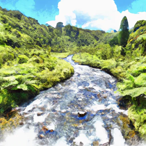
The segment from the headwaters to the confluence with Pelekunu Stream is approximately 5.5 miles long and offers challenging rapids and obstacles such as the "S-turn," "Pinball," and "Jaws." While the rapids can be thrilling, they require technical skills and experience to navigate safely.
As for regulations, there are specific guidelines for the use of the river. The use of life jackets and helmets are mandatory for all participants, and permits are required for commercial operations. Additionally, the area is subject to occasional closures due to dangerous water conditions, so it is important to check for updates before planning a trip.
Overall, the Whitewater River Run offers a thrilling adventure for experienced kayakers and rafters. However, it is important to use caution and follow regulations to ensure a safe and enjoyable experience.
Plan your run down to the hour
Same weather feed Snoflo's iOS app uses -- updated continuously from NOAA / yr.no. Watch the precipitation column on the meteogram; rain ahead of a run typically lifts flows 12-48 hours later depending on the basin.
Next 5 days, hour by hour
Temperature line with weather symbols on top, snow + rain accumulation as columns, humidity as a dotted line.
5-day forecast table
Every 3 hours, broken out across temperature, snow, rain, humidity, and wind. Each cell is colour-coded relative to the column min/max.
| Time | Condition | Temp (°F) | Snow (in) | Rain (in) | Humidity (%) | Wind (mps) | Wind dir |
|---|---|---|---|---|---|---|---|
| Loading detailed forecast… | |||||||
15-day temperature & precipitation
Daily temperatures, snow, and rain projected over the next two weeks -- the upstream story that drives next week's flows.
Regional streamflow levels
USGS streamgauges around Headwaters And Includes All Tributaries To Confluence With Pelekunu Stream -- useful for spotting upstream pulses and gauging which tributary is contributing what.
| Streamgauge | Discharge | View |
|---|---|---|
| Halawa Stream Near Halawa | 6 cfs | → |
| Kaunakakai Gulch At Altitude 75 Feet | · | → |
| Honokohau Stream Near Honokohau | 19 cfs | → |
| Kahakuloa Stream Near Honokohau | 6 cfs | → |
| Waihee River At Dam Near Waihee | 48 cfs | → |
| Iao Stream At Kepaniwai Park Nr Wailuku | 53 cfs | → |
Plan a longer trip
The closest boat launches, other paddle runs, and campgrounds so a day on the water can grow into a full weekend.
Other river runs
- Headwaters To Mouth At Pelekunu Bay
- Headwaters In The Mountain Bogs Between Pepeopae And Pu’U Ali’I Just Above An Elevation Of 4,000 Feet On The Interfluve That Separates Waikolu And Pelekunu Valleys To Ends Where Pipes First Meet The River And Main Diversion Begins
Whitewater safety
- Check the flow before you run
- Use the linked-gauge card and Regional Flow panel above. Class ratings change with flow -- a Class III at low water can become Class IV+ at high water.
- Know your skill ceiling
- Pick runs comfortably below your ceiling. Cold-water and big-water runs raise the consequences of any mistake.
- Wear the right gear
- Helmet, PFD, drysuit / wetsuit when water is below 60°F. Throw bag, knife, and whistle on your person, not in the boat.
- Scout, set safety, and run with a team
- Scout new rapids on foot, set safety with throw bags above the consequence pool, and run with at least one other competent paddler.
- Respect the river
- Strainers, undercuts, low-head dams, and wood can kill at any class rating. When in doubt, portage.
Set push alerts in the Snoflo app
Save Headwaters And Includes All Tributaries To Confluence With Pelekunu Stream as a favorite, set a discharge threshold (e.g. "alert me when flow hits 600 cfs"), and the iOS app pushes the moment the linked gauge crosses.
About Headwaters And Includes All Tributaries To Confluence With Pelekunu Stream
What's the optimal flow for Headwaters And Includes All Tributaries To Confluence With Pelekunu Stream?
The optimal flow depends on the section and the craft. Check the Run Details panel for the linked gauge and current status.
How fresh is the cfs reading on this page?
The linked USGS streamgauge reports continuously (every 15 minutes); Snoflo refreshes throughout the day. Hover the streamflow sparkline to read individual datapoints.
What's the whitewater class?
See the Run Details panel for the class rating Snoflo tracks for this run. Class ratings change with flow -- a Class III at low water can become Class IV in high water.
Where do I put in / take out?
Tap Directions in the hero above to open driving directions to the put-in. For shuttle planning, check the Nearby Boat Launches panel and the river run operator's site.
Can I get alerts when flows hit the optimal range?
Yes -- alerts are managed in the Snoflo iOS app. Favorite this run, set a discharge threshold, and you'll get a push the moment the gauge crosses.
Other runs near here
Snoflo-tracked paddle runs within driving distance of Headwaters And Includes All Tributaries To Confluence With Pelekunu Stream.