Yellowstone Np To Targhee Nf Boundary River Run
Community Reviews
Been here? Share the conditions.
Reviews, ratings & photos are added in the free Snoflo iOS app — rate a spot, tag the conditions, and your visit is verified by location. Add or manage your reviews from the app.
Yellowstone Np To Targhee Nf Boundary
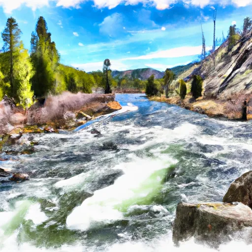
This run is classified as Class III-IV rapids, meaning intermediate to advanced paddling skills are required. The segment mileage is approximately 18 miles, with a total run time of 4-6 hours.
Some of the specific river rapids and obstacles to watch out for include the Colter Falls, which is a Class IV rapid with a large boulder in the center of the channel. The Tumbleweed Rapid, a Class III rapid with a narrow channel and large rocks, is also a challenge.
There are specific regulations for this area, including a permit requirement for commercial outfitters and a strict "pack it in, pack it out" policy for all visitors. Additionally, there are restrictions on camping and campfires in certain areas.
Overall, the Whitewater River Run is an exhilarating experience that requires proper planning, equipment, and safety precautions.
Plan your run down to the hour
Same weather feed Snoflo's iOS app uses -- updated continuously from NOAA / yr.no. Watch the precipitation column on the meteogram; rain ahead of a run typically lifts flows 12-48 hours later depending on the basin.
Next 5 days, hour by hour
Temperature line with weather symbols on top, snow + rain accumulation as columns, humidity as a dotted line.
5-day forecast table
Every 3 hours, broken out across temperature, snow, rain, humidity, and wind. Each cell is colour-coded relative to the column min/max.
| Time | Condition | Temp (°F) | Snow (in) | Rain (in) | Humidity (%) | Wind (mps) | Wind dir |
|---|---|---|---|---|---|---|---|
| Loading detailed forecast… | |||||||
15-day temperature & precipitation
Daily temperatures, snow, and rain projected over the next two weeks -- the upstream story that drives next week's flows.
Regional streamflow levels
USGS streamgauges around Yellowstone Np To Targhee Nf Boundary -- useful for spotting upstream pulses and gauging which tributary is contributing what.
| Streamgauge | Discharge | View |
|---|---|---|
| Falls River Ab Yellowstone Canal Nr Squirrel Id | 506 cfs | → |
| Falls River Nr Squirrel Id | 226 cfs | → |
| Falls River Nr Ashton Id | 466 cfs | → |
| Henrys Fork Nr Ashton Id | 1,580 cfs | → |
| Teton River Ab South Leigh Creek Nr Driggs Id | 310 cfs | → |
| Falls River Nr Chester Id | 304 cfs | → |
Plan a longer trip
The closest boat launches, other paddle runs, and campgrounds so a day on the water can grow into a full weekend.
Boat launches
Other river runs
- Headwaters Of North And South Fork And Mainstem To Targhee Nf Boundary
- Cave Falls Run
- Bitch Creek
- Yellowstone Np Boundary To Confluence With Warm River
- Warm River Springs To Confluence With Henrys Fork
Campgrounds
- Squirrel Meadows Guard Station
- Cave Falls
- Cave Falls Campground
- Little Robinson Creek
- Aspen Acres Rv Park And Golf Course
- Rocky Ford
Points of interest
Whitewater safety
- Check the flow before you run
- Use the linked-gauge card and Regional Flow panel above. Class ratings change with flow -- a Class III at low water can become Class IV+ at high water.
- Know your skill ceiling
- Pick runs comfortably below your ceiling. Cold-water and big-water runs raise the consequences of any mistake.
- Wear the right gear
- Helmet, PFD, drysuit / wetsuit when water is below 60°F. Throw bag, knife, and whistle on your person, not in the boat.
- Scout, set safety, and run with a team
- Scout new rapids on foot, set safety with throw bags above the consequence pool, and run with at least one other competent paddler.
- Respect the river
- Strainers, undercuts, low-head dams, and wood can kill at any class rating. When in doubt, portage.
Set push alerts in the Snoflo app
Save Yellowstone Np To Targhee Nf Boundary as a favorite, set a discharge threshold (e.g. "alert me when flow hits 600 cfs"), and the iOS app pushes the moment the linked gauge crosses.
About Yellowstone Np To Targhee Nf Boundary
What's the optimal flow for Yellowstone Np To Targhee Nf Boundary?
The optimal flow depends on the section and the craft. Check the Run Details panel for the linked gauge and current status.
How fresh is the cfs reading on this page?
The linked USGS streamgauge reports continuously (every 15 minutes); Snoflo refreshes throughout the day. Hover the streamflow sparkline to read individual datapoints.
What's the whitewater class?
See the Run Details panel for the class rating Snoflo tracks for this run. Class ratings change with flow -- a Class III at low water can become Class IV in high water.
Where do I put in / take out?
Tap Directions in the hero above to open driving directions to the put-in. For shuttle planning, check the Nearby Boat Launches panel and the river run operator's site.
Can I get alerts when flows hit the optimal range?
Yes -- alerts are managed in the Snoflo iOS app. Favorite this run, set a discharge threshold, and you'll get a push the moment the gauge crosses.
Other runs near here
Snoflo-tracked paddle runs within driving distance of Yellowstone Np To Targhee Nf Boundary.