Source To Mouth River Run
Community Reviews
Been here? Share the conditions.
Reviews, ratings & photos are added in the free Snoflo iOS app — rate a spot, tag the conditions, and your visit is verified by location. Add or manage your reviews from the app.
Source To Mouth
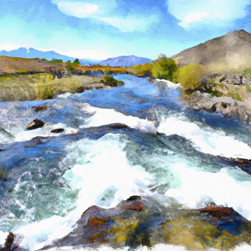
The Whitewater River is divided into four segments, each with unique rapids and obstacles. The Upper section starts at the source and spans 15 miles, featuring exciting rapids such as "Eagle Nest" and "Sheep Dip." The Middle section covers 17 miles and includes challenging rapids like "Hillary's Hole" and "Son of Hillary's." The Lower section stretches for 23 miles and has some of the river's most impressive rapids, including "The Maze" and "Box Canyon."
To ensure safety, specific regulations must be followed on the Whitewater River Run. All paddlers must wear personal flotation devices and helmets, and river guides must be certified to guide trips on the river. Additionally, permits are required for commercial trips, and a Leave No Trace policy is enforced to protect the river's natural beauty.
Overall, the Whitewater River Run in Idaho offers a thrilling and unforgettable experience for experienced paddlers seeking a challenge. With its ideal streamflow range, class rating, unique rapids, and specific regulations, it is a must-visit destination for any adventure seeker.
Plan your run down to the hour
Same weather feed Snoflo's iOS app uses -- updated continuously from NOAA / yr.no. Watch the precipitation column on the meteogram; rain ahead of a run typically lifts flows 12-48 hours later depending on the basin.
Next 5 days, hour by hour
Temperature line with weather symbols on top, snow + rain accumulation as columns, humidity as a dotted line.
5-day forecast table
Every 3 hours, broken out across temperature, snow, rain, humidity, and wind. Each cell is colour-coded relative to the column min/max.
| Time | Condition | Temp (°F) | Snow (in) | Rain (in) | Humidity (%) | Wind (mps) | Wind dir |
|---|---|---|---|---|---|---|---|
| Loading detailed forecast… | |||||||
15-day temperature & precipitation
Daily temperatures, snow, and rain projected over the next two weeks -- the upstream story that drives next week's flows.
Regional streamflow levels
USGS streamgauges around Source To Mouth -- useful for spotting upstream pulses and gauging which tributary is contributing what.
| Streamgauge | Discharge | View |
|---|---|---|
| Logan | 64 cfs | → |
| Logan River Above State Dam | 79 cfs | → |
| Bear River At Idaho-Utah State Line | 931 cfs | → |
| Blacksmith Fork Ab U.P.&L. Co | 52 cfs | → |
| Little Bear River At Paradise | 14 cfs | → |
| Big Creek Near Randolph | 3 cfs | → |
Plan a longer trip
The closest boat launches, other paddle runs, and campgrounds so a day on the water can grow into a full weekend.
Boat launches
- Bear Lake State Park
- Rendezvous Beach State Park
- Lamont Reservoir
- Glendale Reservoir
- North 3000 West Cache County
- Foster Reservoir
Other river runs
- Idaho State Line To Confluence With Beaver Creek
- Southern Boundary Of State Land To Mouth
- Hgh Creek Lake To Nf Boundary
Campgrounds
- Tony Grove Lake Campground
- Tony Grove Lake
- Red Banks Campground
- Lewis M. Turner Campground
- High Creek
- High Creek Campground
Whitewater safety
- Check the flow before you run
- Use the linked-gauge card and Regional Flow panel above. Class ratings change with flow -- a Class III at low water can become Class IV+ at high water.
- Know your skill ceiling
- Pick runs comfortably below your ceiling. Cold-water and big-water runs raise the consequences of any mistake.
- Wear the right gear
- Helmet, PFD, drysuit / wetsuit when water is below 60°F. Throw bag, knife, and whistle on your person, not in the boat.
- Scout, set safety, and run with a team
- Scout new rapids on foot, set safety with throw bags above the consequence pool, and run with at least one other competent paddler.
- Respect the river
- Strainers, undercuts, low-head dams, and wood can kill at any class rating. When in doubt, portage.
Set push alerts in the Snoflo app
Save Source To Mouth as a favorite, set a discharge threshold (e.g. "alert me when flow hits 600 cfs"), and the iOS app pushes the moment the linked gauge crosses.
About Source To Mouth
What's the optimal flow for Source To Mouth?
The optimal flow depends on the section and the craft. Check the Run Details panel for the linked gauge and current status.
How fresh is the cfs reading on this page?
The linked USGS streamgauge reports continuously (every 15 minutes); Snoflo refreshes throughout the day. Hover the streamflow sparkline to read individual datapoints.
What's the whitewater class?
See the Run Details panel for the class rating Snoflo tracks for this run. Class ratings change with flow -- a Class III at low water can become Class IV in high water.
Where do I put in / take out?
Tap Directions in the hero above to open driving directions to the put-in. For shuttle planning, check the Nearby Boat Launches panel and the river run operator's site.
Can I get alerts when flows hit the optimal range?
Yes -- alerts are managed in the Snoflo iOS app. Favorite this run, set a discharge threshold, and you'll get a push the moment the gauge crosses.
Other runs near here
Snoflo-tracked paddle runs within driving distance of Source To Mouth.